Achar, Uruguay
Village in Tacuarembó Department, Uruguay
32°24′0″S 56°11′0″W / 32.40000°S 56.18333°W / -32.40000; -56.18333 Uruguay
 (2011)
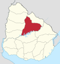
Achar is a village in the Tacuarembó Department of northern-central Uruguay.
Geography
The village is located on Route 43, 10 kilometres (6.2 mi) east of Route 5, on the intersection with the railroad track.
History
On 21 August 1936, the status of the populated centre here was elevated to "Pueblo" (village) by the Act of Ley Nº 9.587.[1]
Population
In 2011 Achar had a population of 687.[2]
| Year | Population |
|---|---|
| 1908 | 2,708 |
| 1963 | 770 |
| 1975 | 608 |
| 1985 | 561 |
| 1996 | 637 |
| 2004 | 780 |
| 2011 | 687 |
Source: Instituto Nacional de Estadística de Uruguay[3]
Places of worship
- St. Joseph Parish Church (Roman Catholic)
Mars
The name Achar has been used for a crater on the planet Mars by the International Astronomical Union, although not specifically commemorating the village.[4]
References
- ^ "Ley Nº 9.587". República Oriental del Uruguay, Poder Legislativo. 1936. Archived from the original on 4 March 2016. Retrieved 6 September 2012.
- ^ "Censos 2011 Tacuarembó (needs flash plugin)". INE. 2012. Archived from the original on 7 January 2013. Retrieved 25 August 2012.
- ^ "Statistics of urban localities (1963–2004)". INE. 2012. Archived from the original (PDF) on 23 March 2015. Retrieved 6 September 2012.
- ^ Categories for Naming Features on Planets and Satellites, Gazetteer of Planetary Nomenclature, USGS Astrogeology Science Center, NASA
External links
- INE map of Achar
- v
- t
- e
 Tacuarembó Department of Uruguay
Capital: Tacuarembó
- Ansina
- Paso de los Toros
- San Gregorio de Polanco
villages
- Achar
- Ansina
- Curtina
- Las Toscas
- Paso Bonilla
- Paso de los Toros
- Paso del Cerro
- San Gregorio de Polanco
- Tacuarembó
- Tambores
 | This article about a place in Tacuarembó Department is a stub. You can help Wikipedia by expanding it. |
- v
- t
- e


