Ahuachapán Department
Department of El Salvador
Department in El Salvador

Flag

Coat of arms
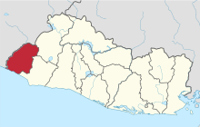
Location within El Salvador
 El Salvador
Ahuachapán (Spanish pronunciation: [awatʃaˈpan]) is a department of El Salvador in the west of the country.[1] The capital is Ahuachapán.[2] In the South it has the Apaneca-Ilamatepec Range and the Cerro Grande de Apaneca (Apaneca Grand Hill).[1] Its has a population of over 360,000 people.[1] The Ahuachapán Department was created by the Legislative Decree of February 9, 1869 under the administration of Francisco Dueñas.
Municipalities
- Ahuachapán Centro
- Ahuachapán Norte
- Ahuachapán Sur
Districts
- Ahuachapán
- Apaneca
- Atiquizaya
- Concepción de Ataco
- El Refugio
- Guaymango
- Jujutla
- San Francisco Menéndez
- San Lorenzo
- San Pedro Puxtla
- Tacuba
- Turín
References
- ^ a b c Perez, Orlando J. (2016-07-26). Historical Dictionary of El Salvador. Rowman & Littlefield. p. 22. ISBN 978-0-8108-8020-7.
- ^ Cohen, Saul Bernard (2008). The Columbia Gazetteer of the World: A to G. Columbia University Press. p. 39. ISBN 978-0-231-14554-1.

| ||
|---|---|---|
|
| |

Authority control databases | |
|---|---|
| International |
|
| National |
|
 | This El Salvador location article is a stub. You can help Wikipedia by expanding it. |
- v
- t
- e


