Ault, Somme
Commune in Hauts-de-France, France

Coat of arms
Location of Ault

(2020–2026) Marcel Le Moigne[1]
1
(2021)[2]
80039 /80460
(avg. 86 m or 282 ft)
Ault (French pronunciation: [olt]; Picard: Eut) is a commune in the Somme department in Hauts-de-France in northern France.
Geography
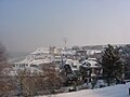
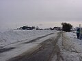
Situated on the English Channel, on the D19 road, 20 miles (32 km) west of Abbeville, in the southwest of the department, Ault possesses chalk cliffs overlooking a beach of pebbles (and sand at low tide). To the south of the town is a large wooded area, the ‘Bois de Cise’, in a valley that leads on to the coast. To the north, the cliffs descend to the level of the beach at Onival. The area around the town, the 'hâble d’Ault' was mostly tidal marshland that has been reclaimed from the sea. Cattle, sheep and game are raised here.
Railways
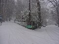
Ault had a station on the standard gauge Woincourt to Onival line, which closed to passengers in May 1939, but saw much use during World War II to move materials for the Atlantic Wall. During the war, a metre gauge line was laid alongside the road from Lanchères, on the CFBS, to Ault. This line was dismantled after the war.[3]
Population
| Year | Pop. | ±% p.a. |
|---|---|---|
| 1968 | 2,014 | — |
| 1975 | 2,192 | +1.22% |
| 1982 | 2,058 | −0.90% |
| 1990 | 2,054 | −0.02% |
| 1999 | 2,070 | +0.09% |
| 2007 | 1,846 | −1.42% |
| 2012 | 1,629 | −2.47% |
| 2017 | 1,464 | −2.11% |
| Source: INSEE[4] | ||
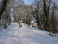
Places of interest
- The 15th / sixteenth century church of Saint-Pierre,
- The war memorial, designed by Paul Landowski.
- Two chapels, at Onival and Bois de Cise dating from the nineteenth century.
- Several ancient village houses.
- The lighthouse, with its lantern over 106 metres above sea-level.
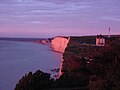
- The cliffs
- The beaches of Ault and Bois de Cise..
- The ‘hâble d'Ault', with signed pathways.
Sea defences
The town has paid a heavy price defending itself against the sea, which is constantly washing away the beach, cliffs and public spaces, such as the car parks and gardens. The problem is ongoing. A "balcony on the sea", a huge concrete construction has been built but the risks remain. Signs of wear of the dyke under the casino have been noted.
-
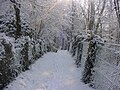
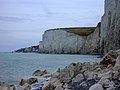 The cliffs
 -
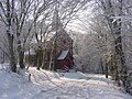
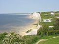 Bois de Cise and cliffs
 -

-

-
-

-
-
-
-
-
-
-

-

-
-


See also
Communes of the Somme department
References
- ^ "Répertoire national des élus: les maires" (in French). data.gouv.fr, Plateforme ouverte des données publiques françaises. 13 September 2022.
- ^ "Populations légales 2021". The National Institute of Statistics and Economic Studies. 28 December 2023.
- ^ Pacey, Philip (2000). Railways of the Baie de Somme. The Oakwood Press (Usk). p. 87. ISBN 0-85361-554-3.
- ^ Population en historique depuis 1968, INSEE
External links
Wikimedia Commons has media related to Ault.
- Official website (in French)
- v
- t
- e
Communes of the Somme department
- Abbevillesubpr
- Ablaincourt-Pressoir
- Acheux-en-Amiénois
- Acheux-en-Vimeu
- Agenville
- Agenvillers
- Aigneville
- Ailly-le-Haut-Clocher
- Ailly-sur-Noye
- Ailly-sur-Somme
- Airaines
- Aizecourt-le-Bas
- Aizecourt-le-Haut
- Albert
- Allaines
- Allenay
- Allery
- Allonville
- Amienspref
- Andainville
- Andechy
- Argœuves
- Argoules
- Arguel
- Armancourt
- Arquèves
- Arrest
- Arry
- Arvillers
- Assainvillers
- Assevillers
- Athies
- Aubercourt
- Aubigny
- Aubvillers
- Auchonvillers
- Ault
- Aumâtre
- Aumont
- Autheux
- Authie
- Authieule
- Authuille
- Avelesges
- Aveluy
- Avesnes-Chaussoy
- Ayencourt
- Bacouel-sur-Selle
- Bailleul
- Baizieux
- Balâtre
- Barleux
- Barly
- Bavelincourt
- Bayencourt
- Bayonvillers
- Bazentin
- Béalcourt
- Beaucamps-le-Jeune
- Beaucamps-le-Vieux
- Beauchamps
- Beaucourt-en-Santerre
- Beaucourt-sur-l'Ancre
- Beaucourt-sur-l'Hallue
- Beaufort-en-Santerre
- Beaumetz
- Beaumont-Hamel
- Beauquesne
- Beauval
- Bécordel-Bécourt
- Becquigny
- Béhen
- Béhencourt
- Bellancourt
- Belleuse
- Belloy-en-Santerre
- Belloy-Saint-Léonard
- Belloy-sur-Somme
- Bergicourt
- Bermesnil
- Bernâtre
- Bernaville
- Bernay-en-Ponthieu
- Bernes
- Berneuil
- Berny-en-Santerre
- Bertangles
- Berteaucourt-les-Dames
- Berteaucourt-lès-Thennes
- Bertrancourt
- Béthencourt-sur-Mer
- Béthencourt-sur-Somme
- Bettembos
- Bettencourt-Rivière
- Bettencourt-Saint-Ouen
- Beuvraignes
- Biaches
- Biarre
- Biencourt
- Billancourt
- Blangy-sous-Poix
- Blangy-Tronville
- Boisbergues
- Le Boisle
- Boismont
- Bonnay
- Bonneville
- Bosquel
- Bouchavesnes-Bergen
- Bouchoir
- Bouchon
- Boufflers
- Bougainville
- Bouillancourt-en-Séry
- Bouillancourt-la-Bataille
- Bouquemaison
- Bourdon
- Bourseville
- Boussicourt
- Bouttencourt
- Bouvaincourt-sur-Bresle
- Bouvincourt-en-Vermandois
- Bouzincourt
- Bovelles
- Boves
- Braches
- Brailly-Cornehotte
- Brassy
- Bray-lès-Mareuil
- Bray-sur-Somme
- Breilly
- Bresle
- Breuil
- Brévillers
- Brie
- Briquemesnil-Floxicourt
- Brocourt
- Brouchy
- Brucamps
- Brutelles
- Buigny-l'Abbé
- Buigny-lès-Gamaches
- Buigny-Saint-Maclou
- Buire-Courcelles
- Buire-sur-l'Ancre
- Bus-la-Mésière
- Bus-lès-Artois
- Bussu
- Bussus-Bussuel
- Bussy-lès-Daours
- Bussy-lès-Poix
- Buverchy
- Cachy
- Cagny
- Cahon
- Caix
- Cambron
- Camon
- Camps-en-Amiénois
- Canaples
- Canchy
- Candas
- Cannessières
- Cantigny
- Caours
- Cappy
- Cardonnette
- Le Cardonnois
- Carnoy-Mametz
- Carrépuis
- Cartigny
- Caulières
- Cavillon
- Cayeux-en-Santerre
- Cayeux-sur-Mer
- Cerisy
- Cerisy-Buleux
- Champien
- Chaulnes
- La Chaussée-Tirancourt
- Chaussoy-Epagny
- La Chavatte
- Chépy
- Chilly
- Chipilly
- Chirmont
- Chuignes
- Chuignolles
- Citerne
- Cizancourt
- Clairy-Saulchoix
- Cléry-sur-Somme
- Cocquerel
- Coigneux
- Coisy
- Colincamps
- Combles
- Condé-Folie
- Contalmaison
- Contay
- Conteville
- Contre
- Conty
- Corbie
- Cottenchy
- Coullemelle
- Coulonvillers
- Courcelette
- Courcelles-au-Bois
- Courcelles-sous-Moyencourt
- Courcelles-sous-Thoix
- Courtemanche
- Cramont
- Crécy-en-Ponthieu
- Crémery
- Cressy-Omencourt
- Creuse
- Croix-Moligneaux
- Croixrault
- Le Crotoy
- Crouy-Saint-Pierre
- Curchy
- Curlu
- Damery
- Dancourt-Popincourt
- Daours
- Dargnies
- Davenescourt
- Démuin
- Dernancourt
- Devise
- Doingt
- Domart-en-Ponthieu
- Domart-sur-la-Luce
- Domesmont
- Dominois
- Domléger-Longvillers
- Dommartin
- Dompierre-Becquincourt
- Dompierre-sur-Authie
- Domqueur
- Domvast
- Doudelainville
- Douilly
- Doullens
- Dreuil-lès-Amiens
- Driencourt
- Dromesnil
- Drucat
- Dury
- Eaucourt-sur-Somme
- L'Échelle-Saint-Aurin
- Éclusier-Vaux
- Embreville
- Englebelmer
- Ennemain
- Épagne-Épagnette
- Épaumesnil
- Épécamps
- Épehy
- Épénancourt
- Éplessier
- Eppeville
- Équancourt
- Équennes-Éramecourt
- Erches
- Ercheu
- Ercourt
- Ergnies
- Érondelle
- Esclainvillers
- Esmery-Hallon
- Essertaux
- Estrébœuf
- Estrées-Deniécourt
- Estrées-lès-Crécy
- Estrées-Mons
- Estrées-sur-Noye
- Étalon
- Ételfay
- Éterpigny
- Étinehem-Méricourt
- L'Étoile
- Étréjust
- Étricourt-Manancourt
- La Faloise
- Falvy
- Famechon
- Faverolles
- Favières
- Fay
- Ferrières
- Fescamps
- Feuillères
- Feuquières-en-Vimeu
- Fieffes-Montrelet
- Fienvillers
- Fignières
- Fins
- Flaucourt
- Flers
- Flers-sur-Noye
- Flesselles
- Fleury
- Flixecourt
- Fluy
- Folies
- Folleville
- Fonches-Fonchette
- Fontaine-le-Sec
- Fontaine-lès-Cappy
- Fontaine-sous-Montdidier
- Fontaine-sur-Maye
- Fontaine-sur-Somme
- Forceville
- Forceville-en-Vimeu
- Forest-l'Abbaye
- Forest-Montiers
- Fort-Mahon-Plage
- Fossemanant
- Foucaucourt-en-Santerre
- Foucaucourt-Hors-Nesle
- Fouencamps
- Fouilloy
- Fouquescourt
- Fourcigny
- Fourdrinoy
- Framerville-Rainecourt
- Framicourt
- Francières
- Franleu
- Franqueville
- Fransart
- Fransu
- Fransures
- Franvillers
- Fréchencourt
- Frémontiers
- Fresnes-Mazancourt
- Fresnes-Tilloloy
- Fresneville
- Fresnoy-Andainville
- Fresnoy-au-Val
- Fresnoy-en-Chaussée
- Fresnoy-lès-Roye
- Fressenneville
- Frettecuisse
- Frettemeule
- Friaucourt
- Fricamps
- Fricourt
- Frise
- Friville-Escarbotin
- Frohen-sur-Authie
- Froyelles
- Frucourt
- Gamaches
- Gapennes
- Gauville
- Gentelles
- Gézaincourt
- Ginchy
- Glisy
- Gorenflos
- Gorges
- Goyencourt
- Grandcourt
- Grand-Laviers
- Gratibus
- Grattepanche
- Grébault-Mesnil
- Grivesnes
- Grivillers
- Grouches-Luchuel
- Gruny
- Guerbigny
- Gueschart
- Gueudecourt
- Guignemicourt
- Guillaucourt
- Guillemont
- Guizancourt
- Guyencourt-Saulcourt
- Guyencourt-sur-Noye
- Hailles
- Hallencourt
- Hallivillers
- Halloy-lès-Pernois
- Hallu
- Ham
- Le Hamel
- Hamelet
- Hancourt
- Hangard
- Hangest-en-Santerre
- Hangest-sur-Somme
- Harbonnières
- Hardecourt-aux-Bois
- Harponville
- Hattencourt
- Hautvillers-Ouville
- Havernas
- Hébécourt
- Hédauville
- Heilly
- Hem-Hardinval
- Hem-Monacu
- Hénencourt
- Herbécourt
- Hérissart
- Herleville
- Herly
- Hervilly
- Hesbécourt
- Hescamps
- Heucourt-Croquoison
- Heudicourt
- Heuzecourt
- Hiermont
- Hombleux
- Hornoy-le-Bourg
- Huchenneville
- Humbercourt
- Huppy
- Hypercourt
- Ignaucourt
- Inval-Boiron
- Irles
- Jumel
- Laboissière-en-Santerre
- Lachapelle
- Lafresguimont-Saint-Martin
- Lahoussoye
- Laleu
- Lamaronde
- Lamotte-Brebière
- Lamotte-Buleux
- Lamotte-Warfusée
- Lanchères
- Lanches-Saint-Hilaire
- Languevoisin-Quiquery
- Laucourt
- Laviéville
- Lawarde-Mauger-l'Hortoy
- Léalvillers
- Lesbœufs
- Liancourt-Fosse
- Licourt
- Liéramont
- Liercourt
- Ligescourt
- Lignières
- Lignières-Châtelain
- Lignières-en-Vimeu
- Lihons
- Limeux
- Liomer
- Long
- Longavesnes
- Longpré-les-Corps-Saints
- Longueau
- Longueval
- Longuevillette
- Louvencourt
- Louvrechy
- Lucheux
- Machiel
- Machy
- Mailly-Maillet
- Mailly-Raineval
- Maisnières
- Maison-Ponthieu
- Maison-Roland
- Maizicourt
- Malpart
- Marcelcave
- Marché-Allouarde
- Marchélepot-Misery
- Marestmontiers
- Mareuil-Caubert
- Maricourt
- Marieux
- Marlers
- Marquaix
- Marquivillers
- Martainneville
- Matigny
- Maucourt
- Maurepas
- Le Mazis
- Méaulte
- Méharicourt
- Meigneux
- Le Meillard
- Méneslies
- Méréaucourt
- Mérélessart
- Méricourt-en-Vimeu
- Méricourt-l'Abbé
- Mers-les-Bains
- Le Mesge
- Mesnil-Bruntel
- Mesnil-Domqueur
- Mesnil-en-Arrouaise
- Mesnil-Martinsart
- Mesnil-Saint-Georges
- Mesnil-Saint-Nicaise
- Métigny
- Mézerolles
- Mézières-en-Santerre
- Miannay
- Millencourt
- Millencourt-en-Ponthieu
- Miraumont
- Mirvaux
- Moislains
- Molliens-au-Bois
- Molliens-Dreuil
- Monchy-Lagache
- Mons-Boubert
- Monsures
- Montagne-Fayel
- Montauban-de-Picardie
- Montdidiersubpr
- Montigny-les-Jongleurs
- Montigny-sur-l'Hallue
- Montonvillers
- Morchain
- Morcourt
- Moreuil
- Morisel
- Morlancourt
- Morvillers-Saint-Saturnin
- Mouflers
- Mouflières
- Moyencourt
- Moyencourt-lès-Poix
- Moyenneville
- Muille-Villette
- Nampont
- Namps-Maisnil
- Nampty
- Naours
- Nesle
- Nesle-l'Hôpital
- Neslette
- Neufmoulin
- Neuilly-le-Dien
- Neuilly-l'Hôpital
- Neuville-au-Bois
- Neuville-Coppegueule
- La Neuville-lès-Bray
- La Neuville-Sire-Bernard
- Neuvillette
- Nibas
- Nouvion
- Noyelles-en-Chaussée
- Noyelles-sur-Mer
- Nurlu
- Occoches
- Ochancourt
- Ô-de-Selle
- Offignies
- Offoy
- Oisemont
- Oissy
- Oneux
- Oresmaux
- Oust-Marest
- Outrebois
- Ovillers-la-Boisselle
- Pargny
- Parvillers-le-Quesnoy
- Pendé
- Pernois
- Péronnesubpr
- Picquigny
- Piennes-Onvillers
- Pierregot
- Pissy
- Plachy-Buyon
- Le Plessier-Rozainvillers
- Pœuilly
- Poix-de-Picardie
- Ponches-Estruval
- Pont-de-Metz
- Ponthoile
- Pont-Noyelles
- Pont-Remy
- Port-le-Grand
- Potte
- Poulainville
- Pozières
- Prouville
- Prouzel
- Proyart
- Puchevillers
- Punchy
- Puzeaux
- Pys
- Quend
- Querrieu
- Le Quesne
- Le Quesnel
- Quesnoy-le-Montant
- Quesnoy-sur-Airaines
- Quevauvillers
- Quiry-le-Sec
- Quivières
- Raincheval
- Rainneville
- Ramburelles
- Rambures
- Rancourt
- Regnière-Écluse
- Remaisnil
- Remaugies
- Remiencourt
- Rethonvillers
- Revelles
- Ribeaucourt
- Ribemont-sur-Ancre
- Riencourt
- Rivery
- Rogy
- Roiglise
- Roisel
- Rollot
- Ronssoy
- Rosières-en-Santerre
- Rouvrel
- Rouvroy-en-Santerre
- Rouy-le-Grand
- Rouy-le-Petit
- Roye
- Rubempré
- Rubescourt
- Rue
- Rumigny
- Saigneville
- Sailly-Flibeaucourt
- Sailly-Laurette
- Sailly-le-Sec
- Sailly-Saillisel
- Sains-en-Amiénois
- Saint-Acheul
- Saint-Aubin-Montenoy
- Saint-Aubin-Rivière
- Saint-Blimont
- Saint-Christ-Briost
- Sainte-Segrée
- Saint-Fuscien
- Saint-Germain-sur-Bresle
- Saint-Gratien
- Saint-Léger-lès-Authie
- Saint-Léger-lès-Domart
- Saint-Léger-sur-Bresle
- Saint-Mard
- Saint-Maulvis
- Saint-Maxent
- Saint-Ouen
- Saint-Quentin-en-Tourmont
- Saint-Quentin-la-Motte-Croix-au-Bailly
- Saint-Riquier
- Saint-Sauflieu
- Saint-Sauveur
- Saint-Vaast-en-Chaussée
- Saint-Valery-sur-Somme
- Saisseval
- Saleux
- Salouël
- Sancourt
- Saulchoy-sous-Poix
- Sauvillers-Mongival
- Saveuse
- Senarpont
- Senlis-le-Sec
- Sentelie
- Seux
- Sorel
- Sorel-en-Vimeu
- Soues
- Sourdon
- Soyécourt
- Surcamps
- Suzanne
- Tailly
- Talmas
- Templeux-la-Fosse
- Templeux-le-Guérard
- Terramesnil
- Tertry
- Thennes
- Thézy-Glimont
- Thiepval
- Thieulloy-l'Abbaye
- Thieulloy-la-Ville
- Thièvres
- Thoix
- Thory
- Tilloloy
- Tilloy-Floriville
- Tincourt-Boucly
- Le Titre
- Tœufles
- Tours-en-Vimeu
- Toutencourt
- Le Translay
- Treux
- Trois-Rivières
- Tully
- Ugny-l'Équipée
- Vadencourt
- Vaire-sous-Corbie
- Valines
- Varennes
- Vauchelles-lès-Authie
- Vauchelles-lès-Domart
- Vauchelles-les-Quesnoy
- Vaudricourt
- Vauvillers
- Vaux-en-Amiénois
- Vaux-Marquenneville
- Vaux-sur-Somme
- Vecquemont
- Velennes
- Vercourt
- Vergies
- Vermandovillers
- Verpillières
- Vers-sur-Selle
- La Vicogne
- Vignacourt
- Villecourt
- Ville-le-Marclet
- Villeroy
- Villers-aux-Érables
- Villers-Bocage
- Villers-Bretonneux
- Villers-Campsart
- Villers-Carbonnel
- Villers-Faucon
- Villers-lès-Roye
- Villers-sous-Ailly
- Villers-sur-Authie
- Villers-Tournelle
- Ville-sur-Ancre
- Vironchaux
- Vismes
- Vitz-sur-Authie
- Voyennes
- Vraignes-en-Vermandois
- Vraignes-lès-Hornoy
- Vrély
- Vron
- Wargnies
- Warloy-Baillon
- Warlus
- Warsy
- Warvillers
- Wiencourt-l'Équipée
- Wiry-au-Mont
- Woignarue
- Woincourt
- Woirel
- Y
- Yaucourt-Bussus
- Yonval
- Yvrench
- Yvrencheux
- Yzengremer
- Yzeux
- pref: prefecture
- subpr: subprefecture
Authority control databases | |
|---|---|
| International |
|
| National |
|
| Geographic |
|
This Arrondissement of Abbeville geographical article is a stub. You can help Wikipedia by expanding it. |
- v
- t
- e


