Camp Byers
Antarctic camp
62°39′49″S 61°05′58″W / 62.663652°S 61.099339°W / -62.663652; -61.099339 Spain
SpainSouth Shetland Islands
Antarctica
(2017)[1]
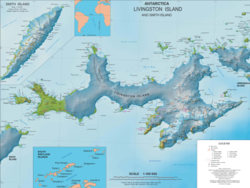
Camp Byers (Spanish: Campamento Byers) is a Spanish seasonal base camp on Byers Peninsula, Livingston Island in the South Shetland Islands, Antarctica. The locality is also designated for use as an International Field Camp. When necessary for scientific research purposes, temporary camping is allowed elsewhere on the protected peninsula under certain conditions.[2]
The area was visited by early 19th century sealers.
Location
The encampment is 1.2 km north-northwest of Nikopol Point, 1.04 km northeast of Sealer Hill, 3.13 km south by west of Chester Cone and 4.38 km west of Dometa Point (detailed Spanish mapping of the area in 1992, Bulgarian mapping in 2005 and 2009).
See also
- Byers Peninsula
- Livingston Island
- Juan Carlos I Base
- List of Antarctic research stations
- List of Antarctic field camps
Maps
- Península Byers, Isla Livingston. Mapa topográfico a escala 1:25000. Madrid: Servicio Geográfico del Ejército, 1992. (Map image on p. 55 of the linked study)
- L.L. Ivanov et al. Antarctica: Livingston Island and Greenwich Island, South Shetland Islands. Scale 1:100000 topographic map. Sofia: Antarctic Place-names Commission of Bulgaria, 2005.
- L.L. Ivanov. Antarctica: Livingston Island and Greenwich, Robert, Snow and Smith Islands. Scale 1:120000 topographic map. Troyan: Manfred Wörner Foundation, 2009. ISBN 978-954-92032-6-4
- Antarctic Digital Database (ADD). Scale 1:250000 topographic map of Antarctica. Scientific Committee on Antarctic Research (SCAR). Since 1993, regularly upgraded and updated.
- L.L. Ivanov. Antarctica: Livingston Island and Smith Island. Scale 1:100000 topographic map. Manfred Wörner Foundation, 2017. ISBN 978-619-90008-3-0
Notes
- ^ a b Antarctic Station Catalogue (PDF) (catalogue). Council of Managers of National Antarctic Programs. August 2017. p. 131. ISBN 978-0-473-40409-3. Archived (PDF) from the original on 22 October 2022. Retrieved 16 January 2023.
- ^ Management Plan for Antarctic Specially Protected Area No. 126 Byers Peninsula. Measure 4 (2016), ATCM XXXIX Final Report. Santiago, 2016
References
- Juan José Durán, Ana Justel Eusebio. La Península Byers: La vida en el Campamento Byers (III). Terralia, Nº 48, 2005, pags. 80–91. ISSN 1138-6223 (in Spanish)
- Ivanov, L. General Geography and History of Livingston Island. In: Bulgarian Antarctic Research: A Synthesis. Eds. C. Pimpirev and N. Chipev. Sofia: St. Kliment Ohridski University Press, 2015. pp. 17–28. ISBN 978-954-07-3939-7
Portals:
 Earth sciences
 Geography
 Spain
Spain

- v
- t
- e
- 17 de Agosto
- Abrazo de Maipú
- Antonio Moro
- Ballvé
- Cabral
- Caleta Péndulo
- Capitán Caillet-Bois
- Capitán Cobbett
- Capitán Estivariz
- Capitán Fliess
- Chacabuco
- Corrientes
- Cristo Redentor
- Dorian Bay
- El Plumerillo
- Florentino Ameghino
- Francisco de Gurruchaga
- General San Martín
- Granaderos
- Groussac
- Livingston
- Martín Güemes I
- Martín Güemes II
- Nogal de Saldán
- Ona
- Ortiz
- San Nicolás
- San Roque
- Virgen de las Nieves
- Yapeyú
- Browning Pass
- Cap Prud'homme
- Cape Roberts
- Icaro
- Byers
| ||||||||
|---|---|---|---|---|---|---|---|---|
| Geography |
|  | ||||||
| History | ||||||||
| Politics | ||||||||
| Society | ||||||||
| Famous explorers | ||||||||
| ||||||||

 | This Livingston Island location article is a stub. You can help Wikipedia by expanding it. |
- v
- t
- e


