Egan Chutes Provincial Park
Provincial park in Ontario, Canada
45°04′49″N 77°44′24″W / 45.08028°N 77.74000°W / 45.08028; -77.74000[1]IUCN category II (national park)
Egan Chutes Provincial Park is located 15 km (9.3 mi) east of Bancroft, Ontario, Canada. It was established as a provincial park in 1989 but is a non-operating park. Egan chutes is classified as a nature reserve, protecting a section of the York River.[5]
History
Egan Chutes Provincial Park was founded in 1989.[5] The park is named after John Egan, a lumber baron.[6]
In 2005, the park was extended with an additional 778 hectares (1,920 acres) that protects noncontiguous sections of the York River over a distance of 30 kilometres (19 mi) downstream. This addition has separate classification (Waterway) from the original park (Nature Reserve).[4][7]
Geology
Egan Chutes Provincial Park is located in the mineral capital of Canada. Nepheline, Biotite, Zircon, Blue Corundum and Sodalite[5] - which is local to the area.[8] Rock and mineral collecting is prohibited in the park.[5]
Recreational activities
Canoeing, sport hunting, camping, hiking, and picnicking are among the activities available at Egan Chutes Provincial Park. There are two main hiking trails, one on each side of the river. The western side is accessed from a larger parking area and is the shorter trail; consequently it is the more frequently visited trail. It visits the namesake Egan Chute and the historical Goulding-Keene Quarry. The other trail across the river is significantly longer and visits the lower two chutes in the park, Goosetail Chute and Farm Chute, as well as some geologically significant sites such as the York River Tactite Zone and Mammoth Rock.[9]
York River is used for canoeing. Within the nature reserve, there are white water extensions associated with the three slideways. Each chute has a fixed conveyor; due to the very steep terrain, transportation is short but difficult. Downstream of the three chutes, the river winds its way, wide and slow. A 31.5 km (19.6 mi) canoe-free trip from the lower part of the Farm Chute to the northernmost boundary of the waterway is possible, with two launching sites along the way.
Winter leisure activities include snowshoeing, cross-country skiing and snowmobiling. There are no licensed snowmobile trails in the park, and snowmobile use is largely restricted to the east side of the river.[7]
Gallery

-
 The York River Tactite Zone, a geologically significant feature of the park.
 -
 Egan Chute, the highest waterfall in the park.
 -
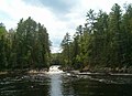 Goosetail Chute, the park's middle waterfall.
 -
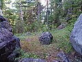
 A view looking down from the top of Mammoth Rock, a geological feature in the park which is said to be the remnant of a prehistoric waterfall.
 -
 A Red Pine growing near the top of Mammoth Rock.
 -
 Farm Chute, the lowest waterfall in the park.
 -
 Ramshorn Rock, located at Farm Chute, is popular for its recognizable shape.
 -
 Atlas Rock, located in the park near Farm Chute, is part of a cliff which partially collapsed but is being held up by a single cedar tree.


References
- ^ "Egan Chutes Provincial Nature Reserve". Geographical Names Data Base. Natural Resources Canada. Retrieved 6 October 2022.
- ^ "Policy Report P56e: EGAN CHUTES PROVINCIAL PARK (NATURE RESERVE CLASS)". Crown Land Use Policy Atlas. Ministry of Natural Resources Ontario. 31 January 2006. Retrieved 6 October 2022.
- ^ "Egan Chutes Provincial Park Addition". Geographical Names Data Base. Natural Resources Canada. Retrieved 6 October 2022.
- ^ a b "Policy Report P56: EGAN CHUTES PROVINCIAL PARK ADDITION (WATERWAY CLASS)". Crown Land Use Policy Atlas. Ministry of Natural Resources Ontario. 31 January 2006. Retrieved 6 October 2022.
- ^ a b c d "Welcome to Egan Chutes Provincial Park". www.ontarioparks.com. Ontario Parks. Retrieved March 22, 2022.
- ^ "Provincial Parks - Egan Chutes". The Couples Resort Area Guide. Retrieved March 22, 2022.
- ^ a b "Egan Chutes Park Management Statement (2004)". ontario.ca. Ministry of Natural Resources Ontario. 2004. Retrieved 6 October 2022.
- ^ Insider, Hastings. "GET CLOSE TO NATURE BY ROCKHOUNDING FOR MINERALS". Hastings - Wildly Authentic. Retrieved March 22, 2022.
- ^ "Egan Chutes Provincial Park - Discover Bancroft". discoverbancroft.com. 2024-01-08. Retrieved 2024-01-09.
External links
![]() Media related to Egan Chutes Provincial Park at Wikimedia Commons
Media related to Egan Chutes Provincial Park at Wikimedia Commons
- v
- t
- e
| |||||||

| |||||
Conservation Authorities & Areas | |
|---|---|
|
|
Related Departments & Agencies | |
|---|---|
|
 Ontario portal
 Category
- Ottawa
- Toronto
 Commons


