Garrochales, Arecibo, Puerto Rico
Barrio of Puerto Rico
Barrio in Arecibo, Puerto Rico
18°27′36″N 66°35′44″W / 18.459937°N 66.595531°W / 18.459937; -66.595531[1] Puerto Rico
 Arecibo
 (2010)
Garrochales is a barrio located in the northeastern area of the municipality of Arecibo, Puerto Rico. Its population in 2010 was 2,433.[3][4][5]
Features and sectors
Garrochales's borders are Islote barrio and Barceloneta municipality on its north; Barceloneta on its east; Sabana Hoyos barrio on its south; and Factor barrio on its west.[6]
Barrios (which are like minor civil divisions)[7] in turn are further subdivided into smaller local populated place areas/units called sectores (sectors in English). The types of sectores may vary, from normally sector to urbanización to reparto to barriada to residencial, among others.[8][9][10]
The following sectors are in Garrochales barrio:[11][12]
Comunidad San Luis, Sector Bethania, Sector Bosque Cambalache, Sector El Alto, Sector El Salao, Sector Factor II, Sector La PRRA, Sector Noriega, Sector Sabana, Sector Salao, Sector San Luis, Urbanización Haciendas de Garrochales, Urbanización Jardines de Bethania, and Urbanización Villas de Garrochales.
History and demographics
Garrochales was in Spain's gazetteers[13] until Puerto Rico was ceded by Spain in the aftermath of the Spanish–American War under the terms of the Treaty of Paris of 1898 and became an unincorporated territory of the United States. In 1899, the United States Department of War conducted a census of Puerto Rico finding that the population of Garrochales barrio was 950.[14]
| Census | Pop. | Note | %± |
|---|---|---|---|
| 1900 | 950 | — | |
| 1910 | 1,338 | 40.8% | |
| 1920 | 979 | −26.8% | |
| 1930 | 1,421 | 45.1% | |
| 1940 | 1,580 | 11.2% | |
| 1950 | 1,585 | 0.3% | |
| 1960 | 1,297 | −18.2% | |
| 1970 | 1,714 | 32.2% | |
| 1980 | 1,965 | 14.6% | |
| 1990 | 2,176 | 10.7% | |
| 2000 | 2,366 | 8.7% | |
| 2010 | 2,433 | 2.8% | |
| U.S. Decennial Census 1899 (shown as 1900)[15] 1910-1930[16] 1930-1950[17] 1980-2000[18] 2010[19] | |||
The industry of Garrochales is cattle farming and dairy.[20]
Gallery
-
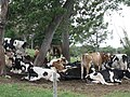 The milk industry of Arecibo on display near Sector Noriega, Jardines de Bethania and Sector San Luis

See also
 Puerto Rico portal

References
- ^ a b "US Gazetteer 2019". US Census. US Government.
- ^ U.S. Geological Survey Geographic Names Information System: Garrochales barrio
- ^ Picó, Rafael; Buitrago de Santiago, Zayda; Berrios, Hector H. Nueva geografía de Puerto Rico: física, económica, y social, por Rafael Picó. Con la colaboración de Zayda Buitrago de Santiago y Héctor H. Berrios. San Juan Editorial Universitaria, Universidad de Puerto Rico,1969.
- ^ Gwillim Law (20 May 2015). Administrative Subdivisions of Countries: A Comprehensive World Reference, 1900 through 1998. McFarland. p. 300. ISBN 978-1-4766-0447-3. Retrieved 25 December 2018.
- ^ Puerto Rico: 2010 Population and Housing Unit Counts.pdf (PDF). U.S. Dept. of Commerce, Economics and Statistics Administration, U.S. Census Bureau. 2010.
- ^ Mapa de municipios y barrios - Arecibo - Memoria Núm. 31 (PDF). University of Puerto Rico: Estado Libre Asociado de Puerto Rico, Oficina del Gobernador, Junta de Planificacion, Santurce, Puerto Rico. 1953. pp. 33–34.
- ^ "US Census Barrio-Pueblo definition". factfinder.com. US Census. Archived from the original on 13 May 2017. Retrieved 5 January 2019.
- ^ "Agencia: Oficina del Coordinador General para el Financiamiento Socioeconómico y la Autogestión (Proposed 2016 Budget)". Puerto Rico Budgets (in Spanish). Retrieved 28 June 2019.
- ^ Rivera Quintero, Marcia (2014), El vuelo de la esperanza: Proyecto de las Comunidades Especiales Puerto Rico, 1997-2004 (first ed.), San Juan, Puerto Rico Fundación Sila M. Calderón, ISBN 978-0-9820806-1-0
- ^ "Leyes del 2001". Lex Juris Puerto Rico (in Spanish). Retrieved 24 June 2020.
- ^ "PRECINTO ELECTORAL ARECIBO 026" (PDF). Comisión Estatal de Elecciones (in Spanish). PR Government. 19 October 2018. Archived from the original (PDF) on 15 June 2020. Retrieved 2 August 2020.
- ^ "PRECINTO ELECTORAL ARECIBO 027" (PDF). Comisión Estatal de Elecciones (in Spanish). PR Government. 8 October 2019. Archived from the original (PDF) on 15 June 2020. Retrieved 2 August 2020.
- ^ "Anuario del comercio, de la industria, de la magistratura y de la administración. 1881". Biblioteca Nacional de España (in Spanish). p. 1614. Retrieved 4 April 2023.
- ^ Joseph Prentiss Sanger; Henry Gannett; Walter Francis Willcox (1900). Informe sobre el censo de Puerto Rico, 1899, United States. War Dept. Porto Rico Census Office (in Spanish). Imprenta del gobierno. p. 160.
- ^ "Report of the Census of Porto Rico 1899". War Department Office Director Census of Porto Rico. Archived from the original on July 16, 2017. Retrieved September 21, 2017.
- ^ "Table 3-Population of Municipalities: 1930 1920 and 1910" (PDF). United States Census Bureau. Archived (PDF) from the original on August 17, 2017. Retrieved September 21, 2017.
- ^ "Table 4-Area and Population of Municipalities Urban and Rural: 1930 to 1950" (PDF). United States Census Bureau. Archived (PDF) from the original on August 30, 2015. Retrieved September 21, 2014.
- ^ "Table 2 Population and Housing Units: 1960 to 2000" (PDF). United States Census Bureau. Archived (PDF) from the original on July 24, 2017. Retrieved September 21, 2017.
- ^ Puerto Rico: 2010 Population and Housing Unit Counts.pdf (PDF). U.S. Dept. of Commerce Economics and Statistics Administration U.S. Census Bureau. 2010. Archived (PDF) from the original on 2017-02-20. Retrieved 2019-08-02.
- ^ Rivera, Lilly. "MARTINEZ DAIRY: UNA VAQUERÍA LOCAL QUE ALIMENTA A PUERTO RICO [A local cattle farm that provides Puerto Rico's nutritional needs]". indulacpr.com. Retrieved 3 August 2020.
- v
- t
- e


