Geißkopf
Mountain in Germany


Geißkopf
Regen, Bavaria, Germany
The Geißkopf is a mountain, 1,097.4 m above sea level (NHN),[1] in the Bavarian Forest in Germany.
Location
The Geißkopf lies near the village of Bischofsmais in the Breitenau, a region to which Breitenauriegel, Dreitannenriegel and Einödriegel also belong.
Tourism
The mountain has been managed since the 1960s as a local recreation area. As well as walking, there is a 1,142-metre-long chair lift which was opened in 1967/68, 3 long and 3 short drag lifts with 9 pistes as well as a sommerrodelbahn and winter toboggan runs. In the summer mountain bikes may be transported on the chair lift and there are 12 descents in the bike park. At the summit is a mountain restaurant and a 23-metre-high wooden observation tower, which enables a good, all-round view of the Rear Bavarian Forest. There is also a transmission antenna for broadcasting the radio programmes of "Unser Radio Regen" on 89.3 MHz with a transmit power of 200 W ERP.[2] It is thus one of the few wooden towers that broadcasts radio programmes today.
A few hundred metres from the top is the Oberbreitenau, a formerly settled clearance. Today it is home to the Landshuter Haus, managed by the Bavarian Forest Club.
Gallery
-
 Viewing tower
 -
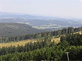 View from the Geißkopf
 -
 Winter tourism on the Geißkopf


References
- ^ Map services of the Federal Agency for Nature Conservation
- ^ www.fmscan.org
External links
Wikimedia Commons has media related to Geißkopf.
- Region Geißkopf
Authority control databases | |
|---|---|
| International |
|
| National |
|
| Geographic |
|


