Gore Bay, New Zealand
Bay in the South Island of New Zealand
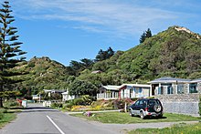
Gore Bay is a coastal settlement about 8 kilometres (5 mi) from Cheviot, New Zealand.
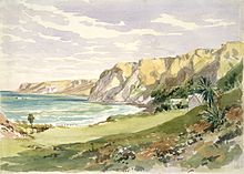
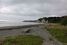
It has a surfing beach with summer beach houses and 14 permanent residents. There are two local camping grounds, each with beach access and business. It is a popular New Year's Eve venue.[citation needed] Of note is Cathedral Gully, a spectacular weathered clay canyon.
The cottage at 60 Moody Street that once belonged to Mrs. Eliza Robinson, wife of local runholder William 'Ready Money' Robinson, is registered by Heritage New Zealand as a Category II structure, with registration number 1769.[1]
Toponymy
The Maori name for this place is Pāua pirau meaning decayed pāua.[2]
The place name Gore Bay is not an official name but is a recorded name that is probably derived from Gore's Bay shown on Captain Cook's map of New Zealand as the bay between Banks Island and the southern island, T’avai Poenammoo.[3]
Climate
| Climate data for Gore Bay | |||||||||||||
|---|---|---|---|---|---|---|---|---|---|---|---|---|---|
| Month | Jan | Feb | Mar | Apr | May | Jun | Jul | Aug | Sep | Oct | Nov | Dec | Year |
| Average precipitation mm (inches) | 61.7 (2.43) | 57.1 (2.25) | 78.4 (3.09) | 80.9 (3.19) | 82.4 (3.24) | 69 (2.7) | 81.1 (3.19) | 79 (3.1) | 53 (2.1) | 61.4 (2.42) | 64.4 (2.54) | 51.8 (2.04) | 820.2 (32.29) |
| Source: Climate Charts[4] | |||||||||||||
References
Wikimedia Commons has media related to Gore Bay, New Zealand.
- ^ "Cottage (for Mrs 'Ready Money' Robinson)". New Zealand Heritage List/Rārangi Kōrero. Heritage New Zealand. Retrieved 17 August 2012.
- ^ "Map of Te Wai Pounamu NZMS 346/2". NZGB place name maps and publications. New Zealand Geographic Board Ngā Pou Taunaha o Aotearoa. Retrieved 11 January 2021.
- ^ "Gore Bay". NZGB Gazetteer. New Zealand Geographic Board Ngā Pou Taunaha o Aotearoa. Retrieved 11 January 2021.
- ^ "Gore Bay, New Zealand Climate, Global Warming, and Daylight Charts and Data". Climate Charts. Retrieved 2 September 2013.
- v
- t
- e
Hurunui District, New Zealand
Seat: Amberley
| Amberley Ward |
|
|---|---|
| Amuri-Hurunui Ward |
|
| Cheviot Ward | |
| Glenmark Ward | |
| Hanmer Springs Ward |
- Ashley Forest
- Conway River
- Doubtful River
- Doubtless River
- Edwards River
- Empson River
- Esk River
- Gelt River
- Glencoe River
- Glencoe River
- Glenrae River
- Grantham River
- Greta River
- Hanmer River
- Harper Pass
- Hundalee Hills
- Hurunui River
- Motunau Island
- Mount Grey / Maukatere
- Lake Tennyson
- Waiau Uwha River
- Waimakariri River
- Waipara River
42°51′31.3″S 173°18′34.3″E / 42.858694°S 173.309528°E / -42.858694; 173.309528


