Grade I and II* listed buildings in the London Borough of Hackney
Map all coordinates using OpenStreetMap
Download coordinates as:
- KML
- GPX (all coordinates)
- GPX (primary coordinates)
- GPX (secondary coordinates)
There are over 9,000 Grade I listed buildings and 20,000 Grade II* listed buildings in England. This page is a list of these buildings in the London Borough of Hackney.
Grade I
| Name | Location | Type | Completed [note 1] | Date designated | Grid ref.[note 2] Geo-coordinates | Entry number [note 3] | Image |
|---|---|---|---|---|---|---|---|
| Church of St Chad | Haggerston | Church | 1868–69 | 3 January 1950 | TQ3373783176 51°31′54″N 0°04′24″W / 51.53166°N 0.07334°W / 51.53166; -0.07334 (Church of St Chad) | 1265793 |  More images |
| Church of St Columba | Hackney | Church | 1868-9 | 3 January 1950 | TQ3344083459 51°32′03″N 0°04′39″W / 51.534274°N 0.077512°W / 51.534274; -0.077512 (Church of St Columba) | 1226862 |  More images |
| Church of St Leonard | Shoreditch | Parish Church | 1736 | 3 January 1950 | TQ3348082632 51°31′37″N 0°04′38″W / 51.526832°N 0.077248°W / 51.526832; -0.077248 (Church of St Leonard) | 1235382 |  More images |
| Church of St Matthias | Stoke Newington | Church | 1851 | 1 September 1953 | TQ3325285488 51°33′09″N 0°04′46″W / 51.552551°N 0.079453°W / 51.552551; -0.079453 (Church of St Matthias) | 1265031 |  More images |
| Church of St Michael | Hackney | Church | 1863-5 | 3 January 1950 | TQ3309582352 51°31′28″N 0°04′58″W / 51.524407°N 0.082901°W / 51.524407; -0.082901 (Church of St Michael) | 1265204 |  More images |
| Old Tower of Former Church of St Augustine | Hackney | Tower | Earlier origin | 24 April 1951 | TQ3499385007 51°32′52″N 0°03′16″W / 51.547815°N 0.054542°W / 51.547815; -0.054542 (Old Tower of Former Church of St Augustine) | 1265635 |  More images |
| St Columba's Vicarage, with Link to Church | Hackney | Vicarage | 1873-4 | 4 February 1975 | TQ3345883477 51°32′04″N 0°04′38″W / 51.534431°N 0.077245°W / 51.534431; -0.077245 (St Columba's Vicarage, with Link to Church) | 1265658 |  More images |
| The Museum of the Home | Hoxton | Museum | c. 1715 | 3 January 1950 | TQ3353383179 51°31′54″N 0°04′35″W / 51.531735°N 0.076278°W / 51.531735; -0.076278 (The Museum of the Home) | 1226772 | 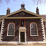 More images |
Grade II*
| Name | Location | Type | Completed [note 1] | Date designated | Grid ref.[note 2] Geo-coordinates | Entry number [note 3] | Image |
|---|---|---|---|---|---|---|---|
| St Mary's Old Church | Hackney | Church | Early 16th century | 1 September 1953 | TQ3286086459 51°33′41″N 0°05′05″W / 51.561369°N 0.084737°W / 51.561369; -0.084737 (St Mary's Old Church) | 1235419 |  More images |
| St Mary's New Church | Hackney | Church | 1858 | 1 September 1953 | TQ3287986400 51°33′39″N 0°05′04″W / 51.560835°N 0.084485°W / 51.560835; -0.084485 (St Mary's New Church) | 1265056 |  More images |
| Ancillary Building to North of Engine House of Metropolitan Water Board | Hackney | Industrial Building | 1854–56 | 27 April 1987 | TQ3229986912 51°33′56″N 0°05′34″W / 51.565572°N 0.092655°W / 51.565572; -0.092655 (Ancillary Building to North of Engine House of Metropolitan Water Board) | 1235562 |  Upload Photo |
| Church of St Andrew | Hackney | Church | 1883-4 | 9 December 1988 | TQ3314387497 51°34′14″N 0°04′49″W / 51.57063°N 0.080264°W / 51.57063; -0.080264 (Church of St Andrew) | 1264896 |  More images |
| Church of St Barnabas | Hackney | Church | 1910 | 24 April 1951 | TQ3380385537 51°33′10″N 0°04′17″W / 51.552861°N 0.071492°W / 51.552861; -0.071492 (Church of St Barnabas) | 1265135 |  More images |
| Church of St John | Hackney | Parish Church | 1792-7 | 24 April 1951 | TQ3507785151 51°32′57″N 0°03′12″W / 51.549089°N 0.053276°W / 51.549089; -0.053276 (Church of St John) | 1226959 |  More images |
| Church of St John of Jerusalem | Hackney | Parish Church | 1845-8 | 24 April 1951 | TQ3559984202 51°32′26″N 0°02′46″W / 51.540436°N 0.046117°W / 51.540436; -0.046117 (Church of St John of Jerusalem) | 1226409 |  More images |
| Church of St John the Baptist | Hoxton, Hackney | Church | Victorian | 3 January 1950 | TQ3302783032 51°31′50″N 0°05′01″W / 51.530534°N 0.083624°W / 51.530534; -0.083624 (Church of St John the Baptist) | 1235285 |  More images |
| Church of St Mark | Dalston, Hackney | Church | 1864–66 | 4 February 1975 | TQ3388585155 51°32′58″N 0°04′14″W / 51.549409°N 0.070455°W / 51.549409; -0.070455 (Church of St Mark) | 1265134 |  More images |
| Church of St Mary of Eton with St Augustine | Hackney | Church | 1880 | 24 April 1951 | TQ3665684782 51°32′43″N 0°01′50″W / 51.545394°N 0.030661°W / 51.545394; -0.030661 (Church of St Mary of Eton with St Augustine) | 1226605 |  More images |
| Clergy House to West of Church of St Michael | Hackney | Clergy House | 1870 | 4 February 1975 | TQ3306482358 51°31′28″N 0°05′00″W / 51.524468°N 0.083345°W / 51.524468; -0.083345 (Clergy House to West of Church of St Michael) | 1226961 |  |
| Engine House of Metropolitan Water Board | Hackney | Engine house | 1854-6 | 16 May 1972 | TQ3231486884 51°33′55″N 0°05′33″W / 51.565317°N 0.092449°W / 51.565317; -0.092449 (Engine House of Metropolitan Water Board) | 1226755 |  More images |
| Former French Protestant Hospital (later Cardinal Pole School) | Victoria Park Road | Hospital | 1864-1865 | 4 February 1975 | TQ3586484065 51°32′21″N 0°02′32″W / 51.539142°N 0.042351430°W / 51.539142; -0.042351430 (Former French Protestant Hospital (later Cardinal Pole School)) | 1235554 |  |
| Hoxton Hall | Hackney | Music Hall | 1863 | 28 June 1972 | TQ3328283186 51°31′55″N 0°04′48″W / 51.531858°N 0.079891°W / 51.531858; -0.079891 (Hoxton Hall) | 1226830 | 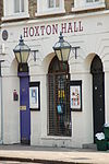 More images |
| Niche in North West Corner of Forecourt of the Museum of the Home | Hackney | Wall | 4 February 1975 | TQ3349183229 51°31′56″N 0°04′37″W / 51.532195°N 0.076864°W / 51.532195; -0.076864 (Niche in North West Corner of Forecourt of the Museum of the Home) | 1265687 |  More images | |
| Pond House | Hackney | Villa | c. 1800 | 24 April 1951 | TQ3498485949 51°33′23″N 0°03′16″W / 51.556282°N 0.05431°W / 51.556282; -0.05431 (Pond House) | 1226931 |  More images |
| Refreshment Rooms | Hackney | Villa | Late 18th century | 1 September 1953 | TQ3275486438 51°33′40″N 0°05′11″W / 51.561206°N 0.086273°W / 51.561206; -0.086273 (Refreshment Rooms) | 1226509 |  More images |
| Sisters' House and School to North of Church of St Columba | Hackney | House | 1898 | 4 February 1975 | TQ3343483481 51°32′04″N 0°04′39″W / 51.534473°N 0.07759°W / 51.534473; -0.07759 (Sisters' House and School to North of Church of St Columba) | 1265691 | Upload Photo |
| St Chad's Vicarage | Hackney | Vicarage | c. 1870 | 4 February 1975 | TQ3373983157 51°31′53″N 0°04′24″W / 51.531489°N 0.073318°W / 51.531489; -0.073318 (St Chad's Vicarage) | 1226697 | Upload Photo |
| St Michael's Church School | Hackney | Church School | 1870 | 4 February 1975 | TQ3304882367 51°31′28″N 0°05′01″W / 51.524553°N 0.083572°W / 51.524553; -0.083572 (St Michael's Church School) | 1226884 |  More images |
| Cathedral of the Nativity of Our Lord, Upper Clapton | Hackney | Church | 1892-5 | 12 September 1969 | TQ3407287831 51°34′24″N 0°04′00″W / 51.573412°N 0.06674°W / 51.573412; -0.06674 (Cathedral of the Nativity of Our Lord, Upper Clapton) | 1235310 |  More images |
| The Hackney Empire | Hackney | Television Studio | 1950's | 28 June 1972 | TQ3491184748 51°32′44″N 0°03′21″W / 51.545508°N 0.055823°W / 51.545508; -0.055823 (The Hackney Empire) | 1226960 |  More images |
| The New Lansdowne Club | Hackney | House | Early 18th century | 24 April 1951 | TQ3492884226 51°32′27″N 0°03′21″W / 51.540813°N 0.055778°W / 51.540813; -0.055778 (The New Lansdowne Club) | 1265590 | Upload Photo |
| United Reformed Church | Hackney | Church | 1869–91 | 7 May 1974 | TQ3515985508 51°33′08″N 0°03′07″W / 51.552278°N 0.051957°W / 51.552278; -0.051957 (United Reformed Church) | 1265632 |  More images |
| 81 and 83 Stoke Newington Church Street | Hackney | House | Early to mid 18th century | 1 September 1953 | TQ3331186548 51°33′43″N 0°04′42″W / 51.562063°N 0.078201°W / 51.562063; -0.078201 (81 and 83 Stoke Newington Church Street) | 1265043 |  |
| 85 and 87 Stoke Newington Church Street | Hackney | House | Early to mid 18th century | 1 September 1953 | TQ3329786544 51°33′43″N 0°04′42″W / 51.56203°N 0.078404°W / 51.56203; -0.078404 (85 and 87 Stoke Newington Church Street) | 1235420 | Upload Photo |
| 187, 189, and 191 High Street | Hackney | House | Early 18th century | 1 September 1953 | TQ3361686613 51°33′45″N 0°04′26″W / 51.562575°N 0.073779°W / 51.562575; -0.073779 (187, 189, and 191 High Street) | 1235537 |  |
| 91–101 Worship Street | Hackney | Dwelling | 1862 | 3 January 1950 | TQ3317582098 51°31′20″N 0°04′55″W / 51.522106°N 0.081844°W / 51.522106; -0.081844 (91–101 Worship Street) | 1235558 |  More images |
| 16 Charles Square | Hackney | House | Early to mid 18th century | 3 January 1950 | TQ3294082635 51°31′37″N 0°05′06″W / 51.526987°N 0.085027°W / 51.526987; -0.085027 (16 Charles Square) | 1265891 |  More images |
| Sutton House, 2 and 4 Homerton High Street | Hackney | House | c. 1530 | 24 April 1951 | TQ3527685090 51°32′55″N 0°03′02″W / 51.548493°N 0.050431°W / 51.548493; -0.050431 (Sutton House, 2 and 4 Homerton High Street) | 1226810 | 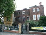 More images |
Notes
- ^ a b The date given is the date used by Historic England as significant for the initial building or that of an important part in the structure's description.
- ^ a b Sometimes known as OSGB36, the grid reference is based on the British national grid reference system used by the Ordnance Survey.
- ^ a b The "List Entry Number" is a unique number assigned to each listed building and scheduled monument by Historic England.
External links
 Media related to Grade I listed buildings in the London Borough of Hackney at Wikimedia Commons
- Media related to Grade II* listed buildings in the London Borough of Hackney at Wikimedia Commons
- v
- t
- e
- Cambridge Heath
- Clapton (including Hackney Downs, Lower Clapton and Upper Clapton)
- Dalston (including Kingsland and Shacklewell)
- De Beauvoir Town
- Finsbury Park (including Manor House)
- Hackney (including Hackney Central, Hackney Wick, Homerton, London Fields and South Hackney)
- Haggerston
- Hoxton
- Lea Bridge
- Manor House
- Newington Green
- Shoreditch
- Stamford Hill
- Stoke Newington
- Temple Mills
- West Hackney

- Abney Park Cemetery
- Abney Park Chapel
- Arcola Theatre
- Clowns Gallery-Museum
- Courtyard Theatre
- Crimes Town Gallery
- Elevator Gallery
- German Hospital
- Gibson Gardens
- Hackney City Farm
- Hackney Empire
- Hackney Museum
- Haggerston Baths
- Hoxton Hall
- Museum of the Home
- Rio Cinema
- Sutton House (NT)
- St Augustine's Tower
- The Towers of Hackney
- The Viktor Wynd Museum
- Victoria Miro Gallery
- Abney Park
- Acton's Lock
- Charles Square
- Clapton Common
- Clapton Square
- Clissold Park
- Fassett Square
- Hackney Brook
- Hackney Cut
- Hackney Downs
- Hackney Marshes
- Haggerston Park
- Hoxton Square
- Lee Navigation
- London Fields
- Mabley Green
- Middlesex Filter Beds Weir
- New River
- Old River Lea
- Regent's Canal
- River Lea
- Shoreditch Park
- Springfield Park
- Stoke Newington Common
- Wenlock Basin
- Woodberry Wetlands
- Hackney South and Shoreditch
- Hackney North and Stoke Newington


- Coat of arms
- Council
- Grade I and II* listed buildings
- People
- Public art
- Schools
 Category
- Commons

Portals:
 London
 Architecture


