Hibernia, New Jersey
Populated place in Morris County, New Jersey, US
Census-designated place in New Jersey, United States
40°56′38″N 74°29′34″W / 40.94389°N 74.49278°W / 40.94389; -74.49278[1] United States
 New Jersey
 (2020)[3]
07866
Hibernia is an unincorporated community and census-designated place (CDP)[5] located along County Route 513 (Green Pond Road) in Rockaway Township of Morris County, in the U.S. state of New Jersey.[1][6] The area is served as United States Postal Service ZIP Code 07842. The community takes its name from Hibernia, the classical name for Ireland.[7]
As of the 2000 United States census, the population for ZIP Code Tabulation Area 07842 was 93.
The Hibernia mines, a series of iron mines worked from pre-Revolutionary times until 1916, are located here.
Since 1970, the former Methodist Episcopal Church on Green Pond Road has been used as a branch of the Rockaway Township Free Public Library.[8]
-
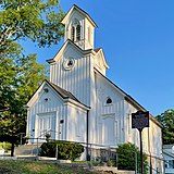 Methodist Episcopal Church, now a library

Demographics
As of the 2020 United States census, the area had a population of 208.[3]
| Census | Pop. | Note | %± |
|---|---|---|---|
| 2020 | 208 | — | |
| U.S. Decennial Census[9] | |||
Notable people
See also: Category:People from Rockaway Township, New Jersey
People who were born in, residents of, or otherwise closely associated with Hibernia include:
- Thomas J. Hillery (1871–1920), President of the New Jersey Senate[10]
References
- ^ a b c "Hibernia". Geographic Names Information System. United States Geological Survey, United States Department of the Interior. Retrieved September 24, 2012.
- ^ "ArcGIS REST Services Directory". United States Census Bureau. Retrieved October 11, 2022.
- ^ a b Census Data Explorer: Hibernia CDP, New Jersey, United States Census Bureau. Accessed June 15, 2023.
- ^ Geographic Codes Lookup for New Jersey, Missouri Census Data Center. Accessed June 9, 2023.
- ^ State of New Jersey Census Designated Places - BVP20 - Data as of January 1, 2020, United States Census Bureau. Accessed December 1, 2022.
- ^ "Locality Search". State of New Jersey.
- ^ Gannett, Henry (1905). The Origin of Certain Place Names in the United States. Govt. Print. Off. pp. 156.
- ^ "Library History". Rockaway Township Free Public Library.
- ^ "Census of Population and Housing". Census.gov. Retrieved June 4, 2016.
- ^ Biographical and Genealogical History of Morris and Sussex Counties, New Jersey. Vol. II. The Lewis Publishing Company. 1899. pp. 615–616 – via Google Books.
External links
 Media related to Hibernia, New Jersey at Wikimedia Commons
- "Hibernia Historic District". The Historical Marker Database.
- Census 2000 Fact Sheet for ZIP Code Tabulation Area 07842 from the United States Census Bureau
- v
- t
- e
Municipalities and communities of Morris County, New Jersey, United States
County seat: Morristown

- Brookside
- Budd Lake
- Cedar Knolls
- Flanders
- Gillette
- Green Village
- Hibernia
- Kenvil
- Lake Hiawatha
- Lake Hopatcong
- Lake Telemark
- Landing
- Ledgewood
- Long Valley
- Lower Berkshire Valley
- Millington
- Mount Hope
- Mount Tabor
- New Vernon
- Oak Ridge
- Parsippany
- Pine Brook
- Pompton Plains
- Port Morris
- Rainbow Lakes
- Stirling
- Succasunna
- Towaco
- Troy Hills
- Whippany
- White Meadow Lake
communities
- New Jersey portal
- United States portal
Authority control databases | |
|---|---|
| International |
|
| National |
|


