Hottot-les-Bagues
You can help expand this article with text translated from the corresponding article in French. (December 2008) Click [show] for important translation instructions.
- View a machine-translated version of the French article.
- Machine translation, like DeepL or Google Translate, is a useful starting point for translations, but translators must revise errors as necessary and confirm that the translation is accurate, rather than simply copy-pasting machine-translated text into the English Wikipedia.
- Do not translate text that appears unreliable or low-quality. If possible, verify the text with references provided in the foreign-language article.
- You must provide copyright attribution in the edit summary accompanying your translation by providing an interlanguage link to the source of your translation. A model attribution edit summary is
Content in this edit is translated from the existing French Wikipedia article at [[:fr:Hottot-les-Bagues]]; see its history for attribution. - You may also add the template
{{Translated|fr|Hottot-les-Bagues}}to the talk page. - For more guidance, see Wikipedia:Translation.
Commune in Normandy, France
Hottot-les-Bagues | ||
|---|---|---|
Commune | ||
 Military cemetery | ||
Location of Hottot-les-Bagues  | ||
(2020–2026) Colette Orieult[1] | | |
| Area 1 | 8.39 km2 (3.24 sq mi) | |
| Population (2021)[2] | 468 | |
| • Density | 56/km2 (140/sq mi) | |
| Time zone | UTC+01:00 (CET) | |
| • Summer (DST) | UTC+02:00 (CEST) | |
| INSEE/Postal code | 14336 /14250 | |
| Elevation | 57–138 m (187–453 ft) (avg. 222 m or 728 ft) | |
| 1 French Land Register data, which excludes lakes, ponds, glaciers > 1 km2 (0.386 sq mi or 247 acres) and river estuaries. | ||
Hottot-les-Bagues (French pronunciation: [ɔto le baɡ] ⓘ) is a commune in the Calvados department and Normandy region of north-western France.
Geography
Hottot-les-Bagues lies 14 kilometres south-east of Bayeux.
History
The fiefdom of Normandy was created for the Viking leader Rollo. Many of the remaining place names are of Norse origin. Hottot is believed to have taken its name from the Old Norse word haugr meaning mound or low hill.
During World War II, the Allied offensive in north-western Europe began with the Normandy landings of 6 June 1944. Within the surrounding district, there was much heavy fighting through June and July 1944 as Commonwealth forces tried to press on from Bayeux in an encircling movement to the south of Caen.
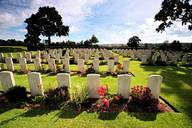
Military cemetery
Hottot-les-Bagues military cemetery contains some 1,137 graves belonging to 965 British soldiers, 34 Canadians, 3 Australians, 2 New Zealanders and 1 South African, together with 132 German soldiers. Most of the war dead lost their lives in the second fortnight of June 1944, in the furious fighting around Tilly-sur-Seulles. The cemetery can be reached from Bayeux by taking the D6 southeast. After passing through Tilly-sur-Seulles, turn westward at Juvigny onto the main road (the D9) that runs from Caen towards Caumont l'Evente.
Population
| Year | Pop. | ±% |
|---|---|---|
| 1962 | 333 | — |
| 1968 | 323 | −3.0% |
| 1975 | 356 | +10.2% |
| 1982 | 370 | +3.9% |
| 1990 | 406 | +9.7% |
| 1999 | 470 | +15.8% |
| 2005 | 471 | +0.2% |
| 2014 | 482 | +2.3% |
See also
References
- ^ "Répertoire national des élus: les maires" (in French). data.gouv.fr, Plateforme ouverte des données publiques françaises. 13 September 2022.
- ^ "Populations légales 2021". The National Institute of Statistics and Economic Studies. 28 December 2023.
External links
Wikimedia Commons has media related to Hottot-les-Bagues.
- Hottot les Bagues War Cemetery
- Normandy War Cemeteries
- Vikings in Normandy
- v
- t
- e
 Communes of the Calvados department
- Ablon
- Agy
- Amayé-sur-Orne
- Amayé-sur-Seulles
- Amfreville
- Angerville
- Anisy
- Annebault
- Arganchy
- Argences
- Arromanches-les-Bains
- Asnelles
- Asnières-en-Bessin
- Auberville
- Aubigny
- Audrieu
- Aure sur Mer
- Aurseulles
- Authie
- Les Authieux-sur-Calonne
- Auvillars
- Avenay
- Balleroy-sur-Drôme
- Banneville-la-Campagne
- Banville
- Barbery
- Barbeville
- Barneville-la-Bertran
- Baron-sur-Odon
- Barou-en-Auge
- Basly
- Basseneville
- Bavent
- Bayeuxsubpr
- Bazenville
- La Bazoque
- Beaufour-Druval
- Beaumais
- Beaumesnil
- Beaumont-en-Auge
- Bellengreville
- Belle Vie en Auge
- Benerville-sur-Mer
- Bénouville
- Bény-sur-Mer
- Bernesq
- Bernières-d'Ailly
- Bernières-sur-Mer
- Beuvillers
- Beuvron-en-Auge
- Biéville-Beuville
- Blainville-sur-Orne
- Blangy-le-Château
- Blay
- Blonville-sur-Mer
- Le Bô
- La Boissière
- Bonnebosq
- Bonnemaison
- Bonneville-la-Louvet
- Bonneville-sur-Touques
- Bonnœil
- Bons-Tassilly
- Bougy
- Boulon
- Bourgeauville
- Bourguébus
- Branville
- Brémoy
- Bretteville-le-Rabet
- Bretteville-sur-Laize
- Bretteville-sur-Odon
- Le Breuil-en-Auge
- Le Breuil-en-Bessin
- Le Brévedent
- Bréville-les-Monts
- Bricqueville
- Brucourt
- Bucéels
- Le Bû-sur-Rouvres
- Cabourg
- Caenpref
- Cagny
- Cahagnes
- Cahagnolles
- La Caine
- Cairon
- La Cambe
- Cambes-en-Plaine
- Cambremer
- Campagnolles
- Campigny
- Canapville
- Canchy
- Canteloup
- Carcagny
- Cardonville
- Carpiquet
- Cartigny-l'Épinay
- Le Castelet
- Castillon
- Castillon-en-Auge
- Castine-en-Plaine
- Caumont-sur-Aure
- Cauvicourt
- Cauville
- Cernay
- Cesny-aux-Vignes
- Cesny-les-Sources
- Chouain
- Cintheaux
- Clarbec
- Clécy
- Cléville
- Colleville-Montgomery
- Colleville-sur-Mer
- Colombelles
- Colombières
- Colombiers-sur-Seulles
- Colomby-Anguerny
- Combray
- Commes
- Condé-en-Normandie
- Condé-sur-Ifs
- Condé-sur-Seulles
- Coquainvilliers
- Cordebugle
- Cordey
- Cormelles-le-Royal
- Cormolain
- Cossesseville
- Cottun
- Courcy
- Courseulles-sur-Mer
- Courtonne-la-Meurdrac
- Courtonne-les-Deux-Églises
- Courvaudon
- Crépon
- Cresserons
- Cresseveuille
- Creully sur Seulles
- Cricquebœuf
- Cricqueville-en-Auge
- Cricqueville-en-Bessin
- Cristot
- Crocy
- Croisilles
- Crouay
- Culey-le-Patry
- Cussy
- Cuverville
- Damblainville
- Danestal
- Deauville
- Démouville
- Le Détroit
- Deux-Jumeaux
- Dialan sur Chaîne
- Dives-sur-Mer
- Donnay
- Douville-en-Auge
- Douvres-la-Délivrande
- Dozulé
- Drubec
- Ducy-Sainte-Marguerite
- Ellon
- Émiéville
- Englesqueville-en-Auge
- Englesqueville-la-Percée
- Épaney
- Épinay-sur-Odon
- Épron
- Équemauville
- Eraines
- Ernes
- Escoville
- Espins
- Esquay-Notre-Dame
- Esquay-sur-Seulles
- Esson
- Estrées-la-Campagne
- Éterville
- Étréham
- Évrecy
- Falaise
- Fauguernon
- Le Faulq
- Feuguerolles-Bully
- Fierville-les-Parcs
- Firfol
- Fleury-sur-Orne
- La Folie
- La Folletière-Abenon
- Fontaine-Étoupefour
- Fontaine-Henry
- Fontaine-le-Pin
- Fontenay-le-Marmion
- Fontenay-le-Pesnel
- Formentin
- Formigny La Bataille
- Foulognes
- Fourches
- Fourneaux-le-Val
- Le Fournet
- Fourneville
- Frénouville
- Le Fresne-Camilly
- Fresné-la-Mère
- Fresney-le-Puceux
- Fresney-le-Vieux
- Fumichon
- Gavrus
- Géfosse-Fontenay
- Genneville
- Gerrots
- Giberville
- Glanville
- Glos
- Gonneville-en-Auge
- Gonneville-sur-Honfleur
- Gonneville-sur-Mer
- Goustranville
- Gouvix
- Grainville-Langannerie
- Grainville-sur-Odon
- Grandcamp-Maisy
- Grangues
- Graye-sur-Mer
- Grentheville
- Grimbosq
- Guéron
- Hermanville-sur-Mer
- Hermival-les-Vaux
- Hérouville-Saint-Clair
- Hérouvillette
- Heuland
- La Hoguette
- Honfleur
- L'Hôtellerie
- Hotot-en-Auge
- Hottot-les-Bagues
- La Houblonnière
- Houlgate
- Ifs
- Isigny-sur-Mer
- Les Isles-Bardel
- Janville
- Jort
- Juaye-Mondaye
- Juvigny-sur-Seulles
- Laize-Clinchamps
- Landelles-et-Coupigny
- Landes-sur-Ajon
- Langrune-sur-Mer
- Léaupartie
- Leffard
- Lessard-et-le-Chêne
- Lingèvres
- Lion-sur-Mer
- Lisieuxsubpr
- Lison
- Lisores
- Litteau
- Livarot-Pays-d'Auge
- Les Loges
- Les Loges-Saulces
- Longues-sur-Mer
- Longueville
- Longvillers
- Loucelles
- Louvagny
- Louvigny
- Luc-sur-Mer
- Magny-en-Bessin
- Maisoncelles-Pelvey
- Maisoncelles-sur-Ajon
- Maisons
- Maizet
- Maizières
- Malherbe-sur-Ajon
- Maltot
- Mandeville-en-Bessin
- Manerbe
- Manneville-la-Pipard
- Le Manoir
- Manvieux
- Le Marais-la-Chapelle
- Marolles
- Martainville
- Martigny-sur-l'Ante
- Mathieu
- May-sur-Orne
- Merville-Franceville-Plage
- Méry-Bissières-en-Auge
- Meslay
- Le Mesnil-au-Grain
- Le Mesnil-Eudes
- Le Mesnil-Guillaume
- Le Mesnil-Robert
- Le Mesnil-Simon
- Le Mesnil-sur-Blangy
- Le Mesnil-Villement
- Meuvaines
- Mézidon Vallée d'Auge
- Le Molay-Littry
- Les Monceaux
- Monceaux-en-Bessin
- Mondeville
- Mondrainville
- Monfréville
- Montfiquet
- Montigny
- Montillières-sur-Orne
- Montreuil-en-Auge
- Monts-en-Bessin
- Les Monts d'Aunay
- Morteaux-Coulibœuf
- Mosles
- Mouen
- Moulines
- Moulins en Bessin
- Moult-Chicheboville
- Les Moutiers-en-Auge
- Les Moutiers-en-Cinglais
- Moyaux
- Mutrécy
- Nonant
- Norolles
- Noron-l'Abbaye
- Noron-la-Poterie
- Norrey-en-Auge
- Notre-Dame-de-Livaye
- Notre-Dame-d'Estrées-Corbon
- Noues de Sienne
- Olendon
- Orbec
- Osmanville
- Ouézy
- Ouffières
- Ouilly-du-Houley
- Ouilly-le-Tesson
- Ouilly-le-Vicomte
- Ouistreham
- Parfouru-sur-Odon
- Pennedepie
- Périers-en-Auge
- Périers-sur-le-Dan
- Périgny
- Perrières
- Pertheville-Ners
- Petiville
- Pierrefitte-en-Auge
- Pierrefitte-en-Cinglais
- Pierrepont
- Le Pin
- Planquery
- Plumetot
- La Pommeraye
- Pont-Bellanger
- Pont-d'Ouilly
- Pontécoulant
- Pont-Farcy
- Pont-l'Évêque
- Port-en-Bessin-Huppain
- Ponts sur Seulles
- Potigny
- Préaux-Bocage
- Le Pré-d'Auge
- Prêtreville
- Putot-en-Auge
- Quetteville
- Ranchy
- Ranville
- Rapilly
- Repentigny
- Reux
- Reviers
- La Rivière-Saint-Sauveur
- La Roque-Baignard
- Rocques
- Rosel
- Rots
- Rouvres
- Rubercy
- Rumesnil
- Ryes
- Saint-André-d'Hébertot
- Saint-André-sur-Orne
- Saint-Arnoult
- Saint-Aubin-d'Arquenay
- Saint-Aubin-des-Bois
- Saint-Aubin-sur-Mer
- Saint-Benoît-d'Hébertot
- Saint-Côme-de-Fresné
- Saint-Contest
- Saint-Denis-de-Mailloc
- Saint-Denis-de-Méré
- Saint-Désir
- Sainte-Croix-sur-Mer
- Sainte-Honorine-de-Ducy
- Sainte-Honorine-du-Fay
- Sainte-Marguerite-d'Elle
- Sainte-Marie-Outre-l'Eau
- Saint-Étienne-la-Thillaye
- Saint-Gatien-des-Bois
- Saint-Germain-de-Livet
- Saint-Germain-du-Pert
- Saint-Germain-la-Blanche-Herbe
- Saint-Germain-Langot
- Saint-Germain-le-Vasson
- Saint-Hymer
- Saint-Jean-de-Livet
- Saint-Jouin
- Saint-Julien-sur-Calonne
- Saint-Lambert
- Saint-Laurent-de-Condel
- Saint-Laurent-sur-Mer
- Saint-Léger-Dubosq
- Saint-Louet-sur-Seulles
- Saint-Loup-Hors
- Saint-Manvieu-Norrey
- Saint-Marcouf
- Saint-Martin-aux-Chartrains
- Saint-Martin-de-Bienfaite-la-Cressonnière
- Saint-Martin-de-Blagny
- Saint-Martin-de-Fontenay
- Saint-Martin-de-la-Lieue
- Saint-Martin-de-Mailloc
- Saint-Martin-de-Mieux
- Saint-Martin-des-Entrées
- Saint-Omer
- Saint-Ouen-du-Mesnil-Oger
- Saint-Ouen-le-Pin
- Saint-Pair
- Saint-Paul-du-Vernay
- Saint-Philbert-des-Champs
- Saint-Pierre-Azif
- Saint-Pierre-Canivet
- Saint-Pierre-des-Ifs
- Saint-Pierre-du-Bû
- Saint-Pierre-du-Fresne
- Saint-Pierre-du-Jonquet
- Saint-Pierre-du-Mont
- Saint-Pierre-en-Auge
- Saint-Rémy
- Saint-Samson
- Saint-Sylvain
- Saint-Vaast-en-Auge
- Saint-Vaast-sur-Seulles
- Saint-Vigor-le-Grand
- Sallen
- Sallenelles
- Sannerville
- Saon
- Saonnet
- Sassy
- Seulline
- Soignolles
- Soliers
- Sommervieu
- Soulangy
- Souleuvre en Bocage
- Soumont-Saint-Quentin
- Subles
- Sully
- Surrain
- Surville
- Terres de Druance
- Tessel
- Thaon
- Le Theil-en-Auge
- Thue et Mue
- Thury-Harcourt-le-Hom
- Tilly-sur-Seulles
- Le Torquesne
- Touffréville
- Touques
- Tour-en-Bessin
- Tourgéville
- Tournières
- Tourville-en-Auge
- Tourville-sur-Odon
- Tracy-Bocage
- Tracy-sur-Mer
- Tréprel
- Trévières
- Troarn
- Le Tronquay
- Trouville-sur-Mer
- Trungy
- Urville
- Ussy
- Vacognes-Neuilly
- Valambray
- Valdallière
- Val d'Arry
- Val de Drôme
- Val-de-Vie
- Valorbiquet
- Valsemé
- Varaville
- Vaucelles
- Vauville
- Vaux-sur-Aure
- Vaux-sur-Seulles
- Vendes
- Vendeuvre
- Versainville
- Verson
- Ver-sur-Mer
- La Vespière-Friardel
- Le Vey
- Vicques
- Victot-Pontfol
- Vienne-en-Bessin
- Vierville-sur-Mer
- Vieux
- Vieux-Bourg
- Vignats
- Villers-Bocage
- Villers-Canivet
- Villers-sur-Mer
- Villerville
- La Villette
- Villons-les-Buissons
- Villy-Bocage
- Villy-lez-Falaise
- Vimont
- Vire Normandiesubpr
- pref: prefecture
- subpr: subprefecture
| Authority control databases: National |
|
|---|
 | This Calvados geographical article is a stub. You can help Wikipedia by expanding it. |
- v
- t
- e


