Jabal Raḩabah
Mountain in the UAE


Jabal Rahabah
Location of Jabal Raḩabah
Show map of United Arab Emirates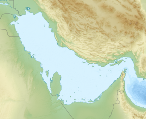
Jabal Rahabah
Jabal Rahabah (Persian Gulf)
Show map of Persian Gulf
Jabal Rahabah
Jabal Rahabah (West and Central Asia)
Show map of West and Central Asia United Arab Emirates
 Ras al-Khaimah
Jabal Raḩabah (Arabic: جبل رحبة)[2] is a peak in the Hajar Mountains, northeast of the United Arab Emirates, in the Emirate of Ras Al Khaimah. At 1,543 m (5,062 ft),[3] it is one of the highest peaks in the UAE, located entirely within the territory of the Emirates [3]
Between Jabal Rahabah (1,543 m (5,062 ft)) and Jabal ar Rahrah (1,691 m (5,548 ft)), the highest peak in the country, there is an important ridge of 5 km (3.1 mi) in length, called Jabal ar Raḩraḩ Ridge, which delimits the drainage divide between those that flow towards the Wadi Ghalilah and the Wādī Shāh or Wadi Shehah, through their respective tributaries.

On the eastern slope of Jabal Rahabah, currently badly damaged by the construction of a wide road,[4] flow intermittent streams and small ravines and wadis tributaries of Wadi Jib, which in turn is a tributary of Wādī Shāh or Wadi Shehah; and on the western slope it forms the Wadi Rahabah / Raḩbah,[5] which flows directly into the Persian Gulf.
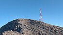
At the top of Jabal Rahabah there is currently a communications antenna, but it is perfectly accessible by following a pedestrian path towards the southwest that starts from Rahabah North Col 1,223 m (4,012 ft), where there are currently installed viewpoints and a service area, commercially identified with the name Viewing Deck Park.
Population
The geographical area of Jabal Rahabah was historically populated by the tribe Bani Shatair (Arabic: بني شطير), one of the two main sections of the Shihuh seminomadic tribe, which occupied, among other territories, the Shihuh tribal area Bani Bakhit.[6]
Geographical features
Jabal Rahabah is the fifth highest peak in United Arab Emirates, located 7.2 km (4.5 mi) to the west of Jebel Jais / Jabal Bil 'Ays (1,911 m (6,270 ft)), whose summit is, however, in the Musandam Governorate, in the Sultanate of Oman[7]
Jabal Rahabah's altitude may seem modest when compared to mountainous locations in other parts of the world, but considering that much of the country has predominantly flat relief, Jabal Rahabah represents a notable exception.
In this sense, the highest mountains in the Emirates, located entirely within its territory, or with its peak located exactly on the border with Oman, are the following:
- Jabal as Sayh (1,746 m) [8] Emirate of Ras Al Khaimah (On the border between UAE and Oman) - Coordinates 25.971889°N, 56.191667°E
- Jabal ar Rahrah (1,691 m) Emirate of Ras Al Khaimah - Coordinates 25.94419°N, 56.15219°E
- Jabal Sal (1,575 m) [9] Emirate of Ras Al Khaimah (On the border between UAE and Oman) - Coordinates 25.93251°N, 56.16921°E
- Jabal Harf Tila (1,568 m) [10] Emirate of Ras Al Khaimah (On the border between UAE and Oman) - Coordinates 25°41'21.4"N 56°09'30.6"E
- Jabal Raḩabah (1,543 m) [11] Emirate of Ras Al Khaimah - Coordinates 25.92610°N, 56.11689°E
- Jabal Yibir / Jabal Al-Mebrah (1,527 m) Emirate of Fujairah - Coordinates 25.64860°N, 56.12860°E
- Jabal Yabānah (1,480 m) [12] Emirate of Ras Al Khaimah (On the border between UAE and Oman) - Coordinates 25.87500°N, 56.16000°E
- Jabal Shintal (1,435 m) [13] Emirate of Ras Al Khaimah - Coordinates 25.94184°N, 56.13511°E
- Jabal Al Ahqab / Jabal Qada‘ah (1,375 m) [14] Emirate of Ras Al Khaimah - Coordinates 25.77781°N, 56.14190°E
Toponymy
Alternative Names: Jabal Rahabah, Jabal Raḩabah, Jabal ar Ra`aylah, Jabal ar Ra‘aylah, Jabal Raḩbah, Jabal Rahaba.
The name of Jabal Rahabah (with the spelling Jabal Raḩabah) was recorded in the documentation and maps produced between 1950 and 1960 by the British Arabist, cartographer, military officer, and diplomat Julian F. Walker,[15] during the work carried out to establish borders between what was then called Trucial States, later completed by the Ministry of Defence (United Kingdom), on 1:100,000 scale maps published in 1971.[16]
See also
- List of mountains in the United Arab Emirates
- List of wadis of the United Arab Emirates
- List of mountains in Oman
- List of wadis in Oman
Gallery
-
 Summit
 -
 To the south of Jabal Raḩabah (1,543 m) a ridge extends, extending for approximately 6 km, paralleling the Persian Gulf coastline


References
- ^ www.peakbagger.com - Jabal Raḩabah, United Arab Emirates
- ^ Mindat.org - Jabal Raḩabah
- ^ a b Geonames.org - Jabal Raḩabah
- ^ Tribulus - Volume 19 - 2011 - Journal of the Emirates Natural History Group - The Flora of the Ru'us al-Jibal -the Mountains of the Musandam Peninsula: An Annotated Checklist and Selected Observations - Gary R. Feulner - Abu Dhabi, United Arab Emirates, 2011<https://enhg.org/Portals/1/trib/V19/TribulusV19.pdf>
- ^ Mindat.org - Wadi Rahbah
- ^ Getamap.net - Bani Bakhīt / Ra's al Khaymah
- ^ Peakbagger.com - Jabal Bil Ays, Oman
- ^ "Jabal as Sayḩ, Umm al Qaywayn, United Arab Emirates".
- ^ "Jabal Sāl, Umm al Qaywayn, United Arab Emirates".
- ^ "GeoNames.org - Jabal Harf Tila (Twin peaks)". www.geonames.org.
- ^ "GeoNames.org - Jabal Raḩabah". www.mindat.org.
- ^ "Jabal Yabānah mountain, Musandam, Oman". om.geoview.info.
- ^ "GeoNames.org Jabal Shintal". www.geonames.org.
- ^ "Mindat.org Jabal Qada'ah". www.geonames.org.
- ^ FCO 18/1932 - 1958- Sketch map drawn by Julian Walker for boundary delimitation: Ras Al Khaimah - The National Archives, London, England
- ^ https://www.agda.ae/en/catalogue/tna/fco/18/1863 Map of Trucial States, Muscat and Oman - Rams - Scale 1:100 000 - Published by D Survey, Ministry of Defence, United Kingdom (1971) - Edition 3-GSGS - The National Archives, London, England
Maps and bibliography
- Julian Fortay Walker (1958) - Sketch map drawn by Julian Walker for boundary delimitation: Ras Al Khaimah - The National Archives, London, England
- Map of Trucial States, Muscat and Oman - Rams - Scale 1:100 000 - Published by D Survey, Ministry of Defence, United Kingdom (1971) - Edition 3-GSGS - The National Archives, London, England
- Heard-Bey, Frauke (2005). From Trucial States to United Arab Emirates : a society in transition. London: Motivate. ISBN 1860631673. OCLC 64689681.
- Lorimer, John (1915). Gazetteer of the Persian Gulf. British Government, Bombay. p. 735.
- Said., Zahlan, Rosemarie (2016). The Origins of the United Arab Emirates : a Political and Social History of the Trucial States. Taylor and Francis. p. 51. ISBN 9781317244653. OCLC 945874284.
External links
![]() Media related to Jabal Raḩabah at Wikimedia Commons
Media related to Jabal Raḩabah at Wikimedia Commons

Hills and mountains on the Arabian Peninsula | |
|---|---|
Note: Mountains are sorted in alphabetical order, unless where it concerns ranges. The highest confirmed mountains in each country are indicated with 'HP', and those with the highest peak are indicated with 'HP', bearing in mind that in the UAE, the highest mountain and the mountain with the highest peak are different. Outcrops are indicated with 'OC', and outliers with 'OL', and anticlines with 'AC'. Volcanoes are indicated with 'V', volcanic craters with 'VC', lava fields with 'LF', and volcanic fields with 'VF'. Other notes:
|


