Jakes Peak
Mountain in the state of California


Jakes Peak
Location in California
Show map of California
Jakes Peak
Jakes Peak (the United States)
Show map of the United StatesJakes Peak is a 9,187-foot-elevation (2,800-meter) mountain summit located in the Sierra Nevada mountain range in El Dorado County, California, United States. It is set within the Desolation Wilderness, on land managed by Eldorado National Forest. This iconic peak is situated above the southwest shore of Lake Tahoe, and approximately seven miles (11 km) northwest of the community of South Lake Tahoe. Topographic relief is significant as the east aspect rises 2,950 feet (900 meters) above the lake in 1.5 miles (2.4 km).
Etymology
This mountain's name remembers ski patroller Jeffery James Smith (1954–1982), commonly known as "Jake", and in honor of the other six persons who also died in an avalanche at the Alpine Meadows Ski Area on March 31, 1982.[5] This landform's toponym was officially adopted in 1985 by the U.S. Board on Geographic Names.[5]
Climate
According to the Köppen climate classification system, Jakes Peak is located in an alpine climate zone.[6] Most weather fronts originate in the Pacific Ocean, and travel east toward the Sierra Nevada mountains. As fronts approach, they are forced upward by the peaks (orographic lift), causing them to drop their moisture in the form of rain or snowfall onto the range. Precipitation runoff from the mountain drains to Lake Tahoe.
Gallery
-
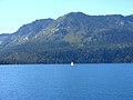
 Southeast aspect above Emerald Bay
 -
 Southeast aspect from Kiva Beach
 -
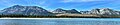
 Jakes Peak (left) and Lake Tahoe from Mount Tallac
 -
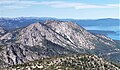
 Mount Tallac (left), Maggies Peaks (center), Jakes Peak (right).
 -
 Jakes Peak seen from Mount Tallac
 -
 Southeast aspect
 -
 Northeast aspect


See also
 Mountains portal
- Desolation Wilderness

References
- ^ a b Barbara Lekisch (1988), Tahoe Place Names: The Origin and History of Names in the Lake Tahoe Basin, Great West Books, ISBN 9780944220016, p. 65
- ^ United States Geological Survey topographical map - Emerald Bay
- ^ a b "Jakes Peak, California". Peakbagger.com. Retrieved 2022-06-07.
- ^ a b c "Jakes Peak - 9,187' CA". listsofjohn.com. Retrieved 2022-06-07.
- ^ a b c "Jakes Peak". Geographic Names Information System. United States Geological Survey, United States Department of the Interior. Retrieved 2022-06-07.
- ^ "Climate of the Sierra Nevada". Encyclopædia Britannica.
External links
- Weather forecast: Jakes Peak
- Jake Smith (story and photo): Tahoe Quarterly
Places adjacent to Jakes Peak | |
|---|---|


