Kati District
District of Unguja South Region, Tanzania
District of South Zanzibar in Unguja South Region, Tanzania
Kati | |
|---|---|
District of South Zanzibar | |
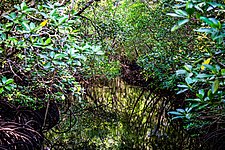 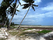 From top to bottom: Jozani Chwaka Bay National Park & Pongwe coast | |
| Nickname: National Park district | |
 Location in Unguja South | |
| Coordinates: 6°5′59″S 39°17′59″E / 6.09972°S 39.29972°E / -6.09972; 39.29972 | |
| Country |  Tanzania Tanzania |
| Region | Unguja South Region |
| Capital | Tunguu |
| Area | |
| • Total | 505.8 km2 (195.3 sq mi) |
| • Rank | 1st in Unguja South |
| Population (2022) | |
| • Total | 132,717 |
| • Rank | 1st in Unguja South |
| • Density | 260/km2 (680/sq mi) |
| Demonym | Zanzibari Kati |
| Ethnic groups | |
| • Settler | Swahili |
| • Native | Hadimu |
Kati District (Wilaya ya Kati in Swahili) is one of two administrative districts of Unguja South Region in Tanzania.[1] The district covers an area of 505.8 km2 (195.3 sq mi).[2] The district is comparable in size to the land area of Guam.[3] The district has a water border to the east and west by the Indian Ocean. The district is bordered to the north by Kaskazini B District of Unguja North Region. To the south Kati District is bordered by Kusini District. The district seat (capital) is the town of Tunguu. The district is the birthplace of Bi Kidude, most famous Zanzibari musician born in Kitumba Village. According to the 2022 census, the district has a total population of 132,717.[4] The Zanzibar University is located in Tunguu and was founded in 2002.
Administrative subdivisions
As of 2012, Kati District was administratively divided into 11 wards.[5]
Wards
|
|
Notable people from Kati District
- Bi Kidude, musician
References
- ^ "Kati District".
- ^ "Kati District Profile" (PDF). Government of Zanzibar. 2019. Retrieved 23 July 2022.
- ^ 541 km2 (209 sq mi) for Guam at "Area size comparison". Nation master. 2022. Retrieved 23 July 2022.
- ^ "2012 Population and Housing Census General Report" (PDF). Government of Tanzania. Retrieved 2022-06-10.
- ^ "Kati District".
- v
- t
- e
Kati District
Capital: Tunguu
- Bambi
- Chwaka
- Dunga
- Jumbi
- Kibojeu
- Koani
- Michamvi
- Ndijani
- Unguja Ukuu
- Uzi
- Uzini
- Unguja Ukuu
- Niamembe Island
- Pongwe
- Unguja Ukuu
 | This Zanzibar Central/South Region location article is a stub. You can help Wikipedia by expanding it. |
- v
- t
- e


