Lake Bindegolly National Park
Protected area in Queensland, Australia
28°00′48″S 144°11′37″E / 28.01333°S 144.19361°E / -28.01333; 144.19361Lake Bindegolly is a national park in Dynevor, Shire of Bulloo, South West Queensland, Australia, 871 km west of Brisbane and 40 km from the town of Thargomindah. It is in the Mulga Lands bioregion and was established to protect a population of the rare plant Acacia ammophila.[1] It has three lakes, two saline and one freshwater.
Birds
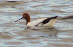
A 318 km2 area of the lake and its surrounds has been identified by BirdLife International as an Important Bird Area (IBA) because it has supported over 1% of the world populations of blue-billed ducks and red-necked avocets as well as populations of the biome-restricted inland dotterel, Bourke's parrot, slaty-backed thornbill, grey-headed honeyeater, black honeyeater, pied honeyeater, Hall's babbler, chirruping wedgebill and chestnut-breasted quail-thrush.[2]
See also
 Queensland portal

References
- ^ Morton, S.R.; Short, J.; & Barker, R.D. Refugia for Biological Diversity in Arid and Semi-arid Australia. Biodiversity Series, Paper No.4. Australian Government Dept of the Environment, Water, Heritage and the Arts."Refugia for Biological Diversity in Arid and Semi-Arid Australia: 13.4 Lakes Numalla, Wyara and Bindegolly". Archived from the original on 4 August 2008. Retrieved 13 May 2008.
- ^ "IBA: Lake Bindegolly". Birdata. Birds Australia. Archived from the original on 6 July 2011. Retrieved 19 July 2011.
External links
- Lake Bindegolly National Park
- v
- t
- e
- Baga
- Blackdown Tableland
- Bulburin
- Byfield
- Capricorn Coast
- Capricornia Cays
- Carnarvon
- Castle Tower
- Curtis Island
- Deepwater
- Epping Forest
- Eurimbula
- Expedition
- Goodedulla
- Humboldt
- Isla Gorge
- Junee
- Keppel Bay Islands
- Kroombit Tops
- Littabella
- Mazeppa
- Minerva Hills
- Mount Archer
- Mount Colosseum
- Mount Etna Caves
- Mount O'Connell
- Mount Walsh
- Nuga Nuga
- Palmgrove
- Peak Range
- Precipice
- Rundle Range
- Snake Range
- Taunton
- Warro
- West Hill
- Wild Cattle Island
- Alwal
- Annan River
- Apudthama
- Barnard Island Group
- Barron Gorge
- Basilisk Range
- Blackbraes
- Bulleringa
- Cape Melville
- Chillagoe-Mungana
- Claremont Isles
- Clump Mountain
- Crater Lakes
- Daintree
- Danbulla
- Davies Creek
- Dinden
- Djiru
- Ella Bay
- Endeavour River
- Eubenangee Swamp
- Family Islands
- Fitzroy Island
- Flinders Group
- Frankland Group
- Forty Mile Scrub
- Great Basalt Wall
- Green Island
- Grey Peaks
- Girramay
- Girringun
- Goold Island
- Hann Tableland
- Hasties Swamp
- Herberton Range
- Hinchinbrook Island
- Hope Islands
- Howick Group
- Hull River
- Japoon
- Kalkajaka
- Kirrama
- Kuranda
- Kurrimine Beach
- Kutini-Payamu
- Lama Lama
- Little Mulgrave
- Lizard Island
- Ma’alpiku Island
- Macalister Range
- Malaan
- Maria Creek
- Marpa
- Michaelmas and Upolu Cays
- Millstream Falls
- Mitchell-Alice Rivers
- Mitirinchi Island
- Moresby Range
- Mount Cook
- Mount Hypipamee
- Mount Lewis
- Mount Spurgeon
- Mount Webb
- Mount Windsor
- Mowbray
- Ngalba Bulal
- Nymph Island
- Oyala Thumotang
- Palmerston Rocks
- Piper Islands
- Possession Island
- Raine Island
- Rinyirru
- Rocky Islets
- Russell River
- Sandbanks
- Saunders Islands
- Sir Charles Hardy Group
- Staaten River
- Starcke
- Three Islands
- Topaz Road
- Tully Gorge
- Turtle Group
- Two Islands
- Undara Volcanic
- Wooroonooran
- Wuthara Island
- Yamarrinh Wachangan Islands
- Yungaburra
- Blackwood
- Brook Islands
- Bowling Green Bay
- Brampton Islands
- Broad Sound Islands
- Cape Hillsborough
- Cape Palmerston
- Cape Upstart
- Conway
- Dipperu
- Dryander
- Eungella
- Gloucester Island
- Halifax Bay Wetlands
- Holbourne Island
- Homevale
- Lindeman Islands
- Magnetic Island
- Molle Islands
- Moorrinya
- Mount Aberdeen
- Mount Martin
- Mount Ossa
- Newry Islands
- Northumberland Islands
- Orpheus Island
- Paluma Range
- Pioneer Peaks
- Reliance Creek
- Repulse Island
- Round Top Island
- Smith Islands
- South Cumberland Islands
- South Island
- Swain Reefs
- Whitsunday Islands
- Auburn River
- Beeron
- Beninbi
- Burrum Coast
- Cania Gorge
- Coalstoun Lakes
- Fairlies Knob
- Goodnight Scrub
- Goomboorian
- Great Sandy
- Grongah
- Mount Bauple
- Pipeclay
- Poona
- Tarong
- Woocoo
- Woondum
- Woowoonga
- Bellthorpe
- Bribie Island
- Burleigh Head
- Conondale
- D'Aguilar
- Deer Reserve
- Dularcha
- Esk
- Eudlo Creek
- Ferntree Creek
- Fort Lytton
- Freshwater
- Gatton
- Glass House Mountains
- Kondalilla
- Lamington
- Lockyer
- Mapleton Falls
- Mooloolah River
- Moogerah Peaks
- Gheebulum Kunungai
- Mount Barney
- Mount Chinghee
- Mount Coolum
- Mount Pinbarren
- Naree Budjong Djara
- Nicoll Scrub
- Noosa
- Nerang
- Ravensbourne
- Sarabah
- Southern Moreton Bay Islands
- St Helena Island
- Springbrook
- Tamborine
- Teerk Roo Ra
- Tewantin
- Triunia
- Tuchekoi
- Venman Bushland
- West Cooroy
- Wickham
 | This Queensland protected areas related article is a stub. You can help Wikipedia by expanding it. |
- v
- t
- e


