Lake Massasecum
43°14′41″N 71°54′54″W / 43.24472°N 71.91500°W / 43.24472; -71.91500Primary outflows tributary of Warner River Basin countries United States Max. length 1.5 mi (2.4 km) Max. width 0.7 mi (1.1 km) Surface area 409 acres (1.66 km2) Average depth 10 ft (3.0 m) Max. depth 50 ft (15 m) Surface elevation 636.7 ft (194.1 m)[1] Islands 3 Settlements Bradford Tributaries Lakes Towns Landmarks
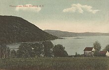
Lake Massasecum is a 409-acre (1.66 km2)[2] water body located in Merrimack County in central New Hampshire, United States, in the town of Bradford. Outflow from the lake travels via the Warner River to the Contoocook River and then the Merrimack River.[3]
The lake is classified as a warmwater fishery, with observed species including smallmouth and largemouth bass, black crappie, chain pickerel, and horned pout.[2]
In the past decade there has been an increase in Myriophyllum (more commonly known as "milfoil") in the lake, and local residents have been trying to stop its spread.[4]
See also
References
- v
- t
- e
Merrimack River watershed
- Amoskeag Falls
- Bear Brook State Park
- Belknap Mountains
- Blackwater Dam
- Egg Rock
- Franconia Notch State Park
- Franklin Falls Dam
- Gunstock Mountain
- Hannah Duston Memorial
- Hobo Railroad
- Lakes Region
- Lost River Reservation
- Middlesex Canal
- Minute Man National Historical Park
- Mount Major
- Mount Monadnock
- Mount Pemigewasset
- Mount Rowe
- Pawtucket Falls
- Pemigewasset Wilderness
- Sculptured Rocks Natural Area
- Wellington State Park
- White Mountains
This New Hampshire state location article is a stub. You can help Wikipedia by expanding it. |
- v
- t
- e