Letschin
Municipality in Brandenburg, Germany

Coat of arms
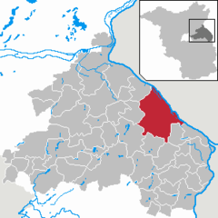
Location of Letschin within Märkisch-Oderland district
(2021–29) Michael Böttcher[1]
(2022-12-31)[2]
15324
Letschin is a municipality in the district of Märkisch-Oderland, in Brandenburg, Germany.
The municipality has ten subdivisions:
|
|
Demography
-
 Development of Population since 1875 within the Current Boundaries (Blue Line: Population; Dotted Line: Comparison to Population Development of Brandenburg state; Grey Background: Time of Nazi rule; Red Background: Time of Communist rule)
 -
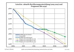 Recent Population Development and Projections (Population Development before Census 2011 (blue line); Recent Population Development according to the Census in Germany in 2011 (blue bordered line); Official projections for 2005-2030 (yellow line); for 2017-2030 (scarlet line); for 2020-2030 (green line)


|
|
|
People
- Katja Havemann (born 1947), civil right activists and author
References
- ^ Landkreis Märkisch-Oderland Wahl der Bürgermeisterin / des Bürgermeisters, accessed 1 July 2021.
- ^ "Bevölkerungsentwicklung und Bevölkerungsstandim Land Brandenburg Dezember 2022" (PDF). Amt für Statistik Berlin-Brandenburg (in German). June 2023.
- ^ Detailed data sources are to be found in the Wikimedia Commons.Population Projection Brandenburg at Wikimedia Commons
External links
![]() Media related to Letschin at Wikimedia Commons
Media related to Letschin at Wikimedia Commons
- v
- t
- e
Towns and municipalities in Märkisch-Oderland
- Alt Tucheband
- Altlandsberg
- Bad Freienwalde
- Beiersdorf-Freudenberg
- Bleyen-Genschmar
- Bliesdorf
- Buckow
- Falkenberg
- Falkenhagen
- Fichtenhöhe
- Fredersdorf-Vogelsdorf
- Garzau-Garzin
- Golzow
- Gusow-Platkow
- Heckelberg-Brunow
- Höhenland
- Hoppegarten
- Küstriner Vorland
- Lebus
- Letschin
- Lietzen
- Lindendorf
- Märkische Höhe
- Müncheberg
- Neuenhagen bei Berlin
- Neuhardenberg
- Neulewin
- Neutrebbin
- Oberbarnim
- Oderaue
- Petershagen-Eggersdorf
- Podelzig
- Prötzel
- Rehfelde
- Reichenow-Möglin
- Reitwein
- Rüdersdorf
- Seelow
- Strausberg
- Treplin
- Vierlinden
- Waldsieversdorf
- Wriezen
- Zechin
- Zeschdorf

Authority control databases | |
|---|---|
| International |
|
| National |
|
| Geographic |
|
 | This Brandenburg location article is a stub. You can help Wikipedia by expanding it. |
- v
- t
- e


