List of Texas State Historic Sites
Official historic sites of the state of Texas may be under the supervision of the Texas Parks and Wildlife Department (TPWD) or the Texas Historical Commission (THC).
- Key
Map all coordinates using OpenStreetMap
Download coordinates as:
- KML
- GPX (all coordinates)
- GPX (primary coordinates)
- GPX (secondary coordinates)
Sites with multiple historic designations are colored according to their highest designation within the following hierarchy.
| #National Historic Landmark (NHL) |
| †National Register of Historic Places (NRHP) |
| ‡NRHP Historic District (HD) |
| ⁂NRHP HD contributing property |
| ⁕State Antiquities Landmark |
| ⁑Recorded Texas Historic Landmark |
| Historic site | Image | Location | Nearest city | County | Coordinates | Supervising agency | Notes |
|---|---|---|---|---|---|---|---|
| Acton State Historic Site |  | FM 167 | Acton | Hood | 32°26′25″N 97°41′5″W / 32.44028°N 97.68472°W / 32.44028; -97.68472 (Acton State Historic Site) | THC | |
| Battleship Texas State Historic Site#†⁕ |  | 3523 Independence Pkwy S. | LaPorte | Harris | 29°45′21″N 95°5′23″W / 29.75583°N 95.08972°W / 29.75583; -95.08972 (Battleship Texas State Historic Site) | TPWD | |
| Bush Family Home State Historic Site | 1412 W. Ohio St. | Midland | Midland | 32°0′2″N 102°5′24″W / 32.00056°N 102.09000°W / 32.00056; -102.09000 | THC | ||
| Caddo Mounds State Historic Site† |  | 1649 W. SH 21 | Alto | Cherokee | 31°35′47″N 95°8′55″W / 31.59639°N 95.14861°W / 31.59639; -95.14861 (Caddo Mounds State Historic Site) | THC | |
| Casa Navarro State Historic Site#†⁕⁑ |  | 228 S. Laredo St. | San Antonio | Bexar | 29°25′23″N 98°29′51″W / 29.42306°N 98.49750°W / 29.42306; -98.49750 (Casa Navarro State Historic Site) | THC | |
| Confederate Reunion Grounds State Historic Site† |  | 1738 FM 2705 | Mexia | Limestone | 31°38′1″N 96°33′26″W / 31.63361°N 96.55722°W / 31.63361; -96.55722 (Confederate Reunion Grounds State Historic Site) | THC | |
| Eisenhower Birthplace State Historic Site†⁑ | 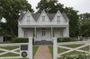 | 609 S. Lamar Ave. | Denison | Grayson | 33°44′59″N 96°32′3″W / 33.74972°N 96.53417°W / 33.74972; -96.53417 (Eisenhower Birthplace State Historic Site) | THC | |
| Fannin Battleground State Historic Site‡ | 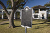 | 734 FM 2506 | Fannin | Goliad | 28°41′11″N 97°14′2″W / 28.68639°N 97.23389°W / 28.68639; -97.23389 (Fannin Battleground State Historic Site) | THC | |
| Fanthorp Inn State Historic Site⁂⁕ |  | 579 S. Main St. | Anderson | Grimes | 30°28′59″N 95°59′2″W / 30.48306°N 95.98389°W / 30.48306; -95.98389 (Fanthorp Inn State Historic Site) | THC | Part of Anderson Historic District |
| Fort Griffin State Historic Site†⁕ |  | 1701 N. US 283 | Albany | Jones | 32°55′11″N 99°13′45″W / 32.91972°N 99.22917°W / 32.91972; -99.22917 (Fort Griffin State Historic Site) | THC | |
| Fort Lancaster State Historic Site†⁕ |  | 629 Ft. Lancaster Rd. | Sheffield | Pecos | 30°39′34″N 101°41′36″W / 30.65944°N 101.69333°W / 30.65944; -101.69333 (Fort Lancaster State Historic Site) | THC | |
| Fort Leaton State Historic Site†⁕ |  | FM 170 E. | Presidio | Presidio | 29°32′33″N 104°19′37″W / 29.54250°N 104.32694°W / 29.54250; -104.32694 (Fort Leaton State Historic Site) | TPWD | |
| Fort McKavett State Historic Site‡ |  | 7066 FM 864 | Fort McKavett | Menard | 30°49′28″N 100°6′38″W / 30.82444°N 100.11056°W / 30.82444; -100.11056 (Fort McKavett State Historic Site) | THC | |
| Fort Richardson State Park and Historic Site#†⁕⁑ |  | 228 Park Road 61 | Jacksboro | Jack | 33°12′22″N 98°9′25″W / 33.20611°N 98.15694°W / 33.20611; -98.15694 (Fort Richardson State Park and Historic Site) | TPWD | |
| French Legation State Historic Site†⁕⁑ |  | 802 San Marcos St. | Austin | Travis | 30°16′01″N 97°43′56″W / 30.26694°N 97.73222°W / 30.26694; -97.73222 (French Legation State Historic Site) | THC | |
| Fulton Mansion State Historic Site†⁕⁑ | 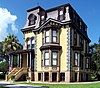 | 317 S. Fulton Beach Rd. | Rockport | Aransas | 28°3′25″N 97°2′7″W / 28.05694°N 97.03528°W / 28.05694; -97.03528 (Fulton Mansion State Historic Site) | THC | |
| Goliad State Park and Historic Site‡⁕⁑ |  | 108 Park Road 6 | Goliad | Goliad | 28°39′23″N 97°23′7″W / 28.65639°N 97.38528°W / 28.65639; -97.38528 (Goliad State Park and Historic Site) | TPWD | |
| Goodnight Ranch State Historic Site† | 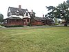 | 4989 CR 25 | Goodnight | Armstrong | 35°1′50″N 101°10′59″W / 35.03056°N 101.18306°W / 35.03056; -101.18306 (Goodnight Ranch State Historic Site) | THC | |
| Hueco Tanks State Park and Historic Site† |  | 6900 Hueco Tanks Road No. 1 | El Paso | El Paso | 31°55′2″N 106°2′38″W / 31.91722°N 106.04389°W / 31.91722; -106.04389 (Hueco Tanks State Park and Historic Site) | TPWD | |
| Landmark Inn State Historic Site†⁕⁑ |  | 402 E. Florence St. | Castroville | Medina | 29°21′18″N 98°52′29″W / 29.35500°N 98.87472°W / 29.35500; -98.87472 (Landmark Inn State Historic Site) | THC | |
| Levi Jordan Plantation State Historic Site⁑ | 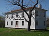 | 7234 FM 521 | Brazoria | Brazoria | 28°59′57″N 95°38′54″W / 28.99917°N 95.64833°W / 28.99917; -95.64833 (Levi Jordan Plantation State Historic Site) | THC | |
| Lipantitlan State Historic Site | Upload image | Lipantitlan Park Rd. | Orange Grove | Nueces | 27°57′53″N 97°49′4″W / 27.96472°N 97.81778°W / 27.96472; -97.81778 (Lipantitlan State Historic Site) | THC | |
| Lyndon B. Johnson State Park and Historic Site‡ |  | Park Road 52 | Stonewall | Gillespie | 30°14′16″N 98°37′35″W / 30.23778°N 98.62639°W / 30.23778; -98.62639 (Lyndon B. Johnson State Park and Historic Site) | TPWD | |
| Magoffin Home State Historic Site†⁂⁕⁑ |  | 1120 Magoffin Ave. | El Paso | El Paso | 31°45′46″N 106°28′39″W / 31.76278°N 106.47750°W / 31.76278; -106.47750 (Magoffin Home State Historic Site) | THC | Part of Magoffin Historic District |
| Mission Dolores State Historic Site† |  | 701 S. Broadway St. | San Augustine | San Augustine | 31°31′27″N 94°6′49″W / 31.52417°N 94.11361°W / 31.52417; -94.11361 (Mission Dolores State Historic Site) | THC | |
| Mission Rosario State Historic Site† | 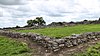 | US 59 | Goliad | Goliad | 28°38′44″N 97°26′23″W / 28.64556°N 97.43972°W / 28.64556; -97.43972 (Mission Rosario State Historic Site) | TPWD | |
| Monument Hill and Kreische Brewery State Historic Sites†⁕ |  | 414 Loop 92 | La Grange | Fayette | 29°53′20″N 96°52′31″W / 29.88889°N 96.87528°W / 29.88889; -96.87528 (Monument Hill and Kreische Brewery State Historic Sites) | THC | |
| National Museum of the Pacific War⁕ |  | 340 E. Main St. | Fredericksburg | Gillespie | 30°16′19″N 98°52′2″W / 30.27194°N 98.86722°W / 30.27194; -98.86722 (National Museum of the Pacific War) | THC | |
| Port Isabel Lighthouse State Historic Site† | 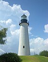 | 421 E. Queen Isabella Blvd. | Port Isabel | Cameron | 26°4′41″N 97°12′26″W / 26.07806°N 97.20722°W / 26.07806; -97.20722 (Port Isabel Lighthouse State Historic Site) | THC | |
| Sabine Pass Battleground State Historic Site |  | 6100 Dowling Rd. | Port Arthur | Jefferson | 29°43′43″N 93°52′30″W / 29.72861°N 93.87500°W / 29.72861; -93.87500 (Sabine Pass Battleground State Historic Site) | THC | |
| Sam Bell Maxey House State Historic Site†⁕⁑ |  | 812 S. Church St. | Paris | Lamar | 33°39′14″N 95°33′17″W / 33.65389°N 95.55472°W / 33.65389; -95.55472 (Sam Bell Maxey House State Historic Site) | THC | |
| Sam Rayburn House State Historic Site#†⁑ |  | 890 W. SH 56 | Bonham | Fannin | 33°34′10″N 96°12′27″W / 33.56944°N 96.20750°W / 33.56944; -96.20750 (Sam Rayburn House State Historic Site) | THC | |
| San Felipe de Austin State Historic Site‡ |  | 15945 FM 1458 | San Felipe | Austin | 29°48′25″N 96°5′51″W / 29.80694°N 96.09750°W / 29.80694; -96.09750 (San Felipe de Austin State Historic Site) | THC | |
| San Jacinto Battleground State Historic Site#†⁕ |  | 3523 Independence Pkwy S. | LaPorte | Harris | 29°44′18″N 95°4′41″W / 29.73833°N 95.07806°W / 29.73833; -95.07806 (San Jacinto Battleground State Historic Site) | THC | |
| Seminole Canyon State Park and Historic Site‡ | 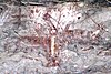 | US 90 | Comstock | Val Verde | 29°42′0″N 101°18′47″W / 29.70000°N 101.31306°W / 29.70000; -101.31306 (Seminole Canyon State Park and Historic Site) | TPWD | |
| Starr Family Home State Historic Site†⁕ | 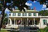 | 407 W. Travis St. | Marshall | Harrison | 32°32′30″N 94°22′15″W / 32.54167°N 94.37083°W / 32.54167; -94.37083 (Starr Family Home State Historic Site) | THC | |
| Varner–Hogg Plantation State Historic Site†⁕⁑ |  | 1702 N. 13th St. | West Columbia | Brazoria | 29°9′45″N 95°38′28″W / 29.16250°N 95.64111°W / 29.16250; -95.64111 (Varner–Hogg Plantation State Historic Site) | THC | |
| Washington-on-the-Brazos State Historic Site | 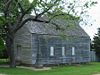 | 23400 Park Road 12 | Washington | Washington | 30°19′25″N 96°9′17″W / 30.32361°N 96.15472°W / 30.32361; -96.15472 (Washington-on-the-Brazos State Historic Site) | THC | |
| Zaragoza Birthplace State Historic Site⁕ | 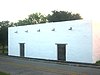 | Calle Cinco de Mayo at Lopez Rd. | Goliad | Goliad | 28°38′50″N 97°22′59″W / 28.64722°N 97.38306°W / 28.64722; -97.38306 (Zaragoza Birthplace State Historic Site) | TPWD |


