Lists of earthquakes
Earthquakes are caused by movements within the Earth's crust and uppermost mantle. They range from weak events detectable only by seismometers, to sudden and violent events lasting many minutes which have caused some of the greatest disasters in human history. Below, earthquakes are listed by period, region or country, year, magnitude, cost, fatalities and number of scientific studies.
Lists by time period
By century
By decade
By year
- 1900
- 1901
- 1902
- 1903
- 1904
- 1905
- 1906
- 1907
- 1908
- 1909
- 1910
- 1911
- 1912
- 1913
- 1914
- 1915
- 1916
- 1917
- 1918
- 1919
- 1920
- 1921
- 1922
- 1923
- 1924
- 1925
- 1926
- 1927
- 1928
- 1929
- 1930
- 1931
- 1932
- 1933
- 1934
- 1935
- 1936
- 1937
- 1938
- 1939
- 1940
- 1941
- 1942
- 1943
- 1944
- 1945
- 1946
- 1947
- 1948
- 1949
- 1950
- 1951
- 1952
- 1953
- 1954
- 1955
- 1956
- 1957
- 1958
- 1959
- 1960
- 1961
- 1962
- 1963
- 1964
- 1965
- 1966
- 1967
- 1968
- 1969
- 1970
- 1971
- 1972
- 1973
- 1974
- 1975
- 1976
- 1977
- 1978
- 1979
- 1980
- 1981
- 1982
- 1983
- 1984
- 1985
- 1986
- 1987
- 1988
- 1989
- 1990
- 1991
- 1992
- 1993
- 1994
- 1995
- 1996
- 1997
- 1998
- 1999
- 2000
- 2001
- 2002
- 2003
- 2004
- 2005
- 2006
- 2007
- 2008
- 2009
- 2010
- 2011
- 2012
- 2013
- 2014
- 2015
- 2016
- 2017
- 2018
- 2019
- 2020
- 2021
- 2022
- 2023
- 2024
Lists by location
By country
- Afghanistan
- Albania
- Algeria
- Argentina
- Armenia
- Australia
- Azerbaijan
- Bangladesh
- Bosnia and Herzegovina
- Brazil
- Bulgaria
- Canada
- Chile
- China
- Colombia
- Costa Rica
- Croatia
- Cuba
- Cyprus
- Democratic Republic of the Congo
- Dominican Republic
- East Timor
- Ecuador
- Egypt
- El Salvador
- Eritrea
- Ethiopia
- France
- Fiji
- Georgia
- Germany
- Ghana
- Greece
- Guam
- Guatemala
- Haiti
- Iceland
- India
- Indonesia
- Iran
- Italy
- Japan
- Kosovo
- Kazakhstan
- Kyrgyzstan
- Malaysia
- Mexico
- Morocco
- Myanmar
- Nepal
- Netherlands
- New Zealand
- Nicaragua
- Pakistan
- Palestine
- Panama
- Papua New Guinea
- Peru
- Philippines
- Portugal
- Romania
- Russia
- Samoa
- Saudi Arabia
- Slovenia
- Solomon Islands
- South Africa
- South Korea
- Spain
- Taiwan
- Tajikistan
- Thailand
- Tonga
- Turkey
- United States
- Vanuatu
- Venezuela
- Yemen
By region
Deadliest earthquakes by year


Largest earthquakes by year
| Year | Magnitude | Location | Depth (km) | MMI | Deaths | Injuries |
|---|---|---|---|---|---|---|
| January 7, 1937[8] | 7.8 |  China, Qinghai China, Qinghai | 15.0 | VIII | 0 | 0 |
| February 1, 1938 | 8.5–8.6 |  Dutch East Indies, Maluku offshore Dutch East Indies, Maluku offshore | 60.0 | VII | 0 | 0 |
| December 21, 1939[9] | 8.1 | Dutch East Indies, Central Sulawesi offshore | 150.0 | VII | 0 | 0 |
| May 24, 1940 | 8.2 |  Peru, Lima Peru, Lima | 45.0 | VIII | 179–300 | 3,500 |
| November 18, 1941 | 8.0 |  Japan, Miyazaki offshore Japan, Miyazaki offshore | 35.0 | VII | 2 | 0 |
| August 24, 1942 | 8.2 | Peru, Ica | 35.0 | IX | 30 | 25 |
| April 6, 1943 | 7.9–8.2 |  Chile, Coquimbo Chile, Coquimbo | 35.0 | VIII | 11 | 0 |
| December 7, 1944 | 8.1 | Japan, Wakayama offshore | 30.0 | VIII | 1,223 | 2,135 |
| November 27, 1945 | 8.1 |  India, Balochistan offshore India, Balochistan offshore | 15.0 | X | 4,000 | 0 |
| April 1, 1946 | 8.6 |  United States, Alaska offshore United States, Alaska offshore | 15.0 | VI | 173 | 0 |
| May 27, 1947[10] & November 1, 1947 | 7.6 | Dutch East Indies, Papua offshore | 15.0 | VI | 0 | 0 |
| Peru, Junin | 20.0 | IX | 233 | 0 | ||
| January 24, 1948 | 7.8 |  Philippines, Panay Philippines, Panay | 15.0 | X | 50 | 0 |
| August 22, 1949 | 8.0 |  Canada, Haida Gwaii Canada, Haida Gwaii | 10.0 | VIII | 0 | 0 |
| August 15, 1950 | 8.6 |   India–China, Assam–Tibet border region India–China, Assam–Tibet border region | 15.0 | XI | 4,800 | 0 |
| November 24, 1951 | 7.8 | Taiwan, East Rift Valley | 30.0 | VII | 85 | 1,200 |
| November 4, 1952 | 9.0 |  Soviet Union, Kamchatka Soviet Union, Kamchatka | 21.6 | XI | 2,336 | 0 |
| November 25, 1953[11] | 7.9 | Japan, Yokohama | 25.0 | V | 1 | 0 |
| March 29, 1954[12] | 7.8 |  Spain, Andalusia Spain, Andalusia | 626.2 | IV | 0 | 0 |
| February 27, 1955[13] | 7.5 |  New Zealand, Kermadec Islands New Zealand, Kermadec Islands | 15.0 | I | 0 | 0 |
| July 9, 1956 | 7.7 |  Greece, Dodecanese Islands Greece, Dodecanese Islands | 20.0 | IX | 56 | 0 |
| March 9, 1957 | 8.6–9.1 | United States, Aleutian Islands, Alaska | 25.0 | VIII | 2 | 0 |
| November 6, 1958 | 8.3 |  Soviet Union, Kuril Islands Soviet Union, Kuril Islands | 35.0 | X | 0 | 51 |
| May 4, 1959 | 7.9 | Soviet Union, Kamchatka | 55.0 | VIII | 1 | 13 |
| May 22, 1960 | 9.5 | Chile, Valdivia | 25.0 | XII | 6,000 | 11,000 |
| August 19, 1961[14] | 7.6 |  Peru, Madre de Dios Region Peru, Madre de Dios Region | 612.2 | IV | 0 | 0 |
| May 21, 1962[15] | 7.5 |  Fiji offshore Fiji offshore | 390.0 | I | 0 | 0 |
| October 13, 1963 | 8.5 | Soviet Union, Kuril Islands | 35.0 | IX | 0 | 0 |
| March 27, 1964 | 9.1–9.2 |  Alaska, Prince William Sound Alaska, Prince William Sound | 25.0 | XI | 131 | 0 |
| February 3, 1965 | 8.7 | Alaska, Aleutian Islands | 30.3 | VI | 0 | 0 |
| October 17, 1966 | 8.1 | Peru, Arequipa | 38.0 | IX | 125 | 3,000 |
| July 22, 1967 | 7.4 |  Turkey, Sakarya Province Turkey, Sakarya Province | 30.0 | X | 86 | 0 |
| May 16, 1968 | 8.3 | Japan, Hokkaidō | 26.0 | VIII | 52 | 330 |
| August 11, 1969[16] | 8.2 | Soviet Union, Kuril Islands | 30.0 | VIII | 0 | 0 |
| July 31, 1970 | 8.0 |  Colombia, Amazonas Department Colombia, Amazonas Department | 644.8 | IV | 1 | 4 |
| July 26, 1971 | 8.1 |  Papua New Guinea, Kokopo Papua New Guinea, Kokopo | 37.0 | IX | 3 | 5 |
| 1972[17] | 8.0 | Philippines, Mindanao | 60.0 | VII | 0 | 0 |
| June 17, 1973 | 7.8 | Japan, Hokkaidō | 43.3 | VIII | 0 | 27 |
| October 3, 1974 | 8.1 | Peru, Lima | 13.0 | IX | 78 | 2,400 |
| May 26, 1975 | 7.9 | north Atlantic Ocean | 33.0 | VI | 0 | 0 |
| August 17, 1976 | 8.0 | Philippines, Moro Gulf | 33.0 | VIII | 8,000 | 10,000 |
| August 19, 1977 | 8.3 |  Indonesia, Bima Indonesia, Bima | 25.0 | VI | 189 | 1,100 |
| June 12, 1978 | 7.7 | Japan, Miyagi | 44.0 | VIII | 28 | 1,325 |
| December 12, 1979 | 8.2 | Colombia, Nariño offshore Ecuador, Esmeraldas offshore Ecuador, Esmeraldas offshore | 24.0 | IX | 600 | 0 |
| July 17, 1980[18] | 7.7 |  Solomon Islands, Santa Cruz Islands Solomon Islands, Santa Cruz Islands | 33.0 | VI | 0 | 0 |
| September 1, 1981[19] | 7.6 | New Zealand, offshore | 25.0 | IV | 0 | 0 |
| June 19, 1982 | 7.3 |  El Salvador, offshore El Salvador, offshore | 73.0 | VII | 43 | 0 |
| March 18[20] & May 26, 1983 | 7.7 | Papua New Guinea, New Ireland | 70.0 | VII | 0 | 0 |
 Japan, off the coast of Honshu Japan, off the coast of Honshu | 15.1 | VIII | 104 | 324 | ||
| February 7, 1984[21] | 7.6 | Solomon Islands, Honiara | 18.1 | VIII | 0 | 0 |
| September 19, 1985 | 8.0 |  Mexico, Mexico City Mexico, Mexico City | 27.9 | IX | 10,000 | 30,000 |
| May 7, 1986[22] | 8.0 | United States, Aleutian Islands, Alaska | 19.0 | VII | 0 | 0 |
| November 30, 1987[23] | 7.9 | United States, Gulf of Alaska | 10.0 | VI | 0 | 0 |
| March 6, 1988[24] | 7.7 | , Gulf of Alaska | 15.0 | V | 0 | 0 |
| May 23, 1989[25] | 8.0 |  Australia, Macquarie Island Australia, Macquarie Island | 10.0 | V | 0 | 0 |
| July 16, 1990 | 7.7 |  Philippines, Luzon Philippines, Luzon | 24.4 | IX | 1,621 | 3,000 |
| April 22, 1991 | 7.6 |  Costa Rica, Limón Costa Rica, Limón | 10.0 | IX | 127 | 759 |
| December 12, 1992 | 7.8 | Indonesia, Sunda Islands | 23.5 | VIII | 2,500 | 0 |
| August 8, 1993 | 7.8 |  Guam, Offshore Guam, Offshore | 59.3 | IX | 0 | 71 |
| October 5, 1994 | 8.3 |  Russia, Kuril Islands Russia, Kuril Islands | 3.0 | IX | 12 | 1,742 |
| July 30, 1995 | 8.0 | Chile, Antofagasta | 30.5 | VII | 3 | 59 |
| February 17, 1996 | 8.2 | Indonesia, Biak | 11.5 | VIII | 166 | 423 |
| December 5, 1997[26] | 7.8 | Russia, Kamchatka Peninsula | 23.5 | VIII | 0 | 0 |
| March 25, 1998 | 8.1 | 10.0 | – | 0 | 0 | |
| September 21, 1999 | 7.7 | Taiwan, Nantou County | 15.5 | IX | 2,444 | 11,305 |
| November 16, 2000 | 8.0 | Papua New Guinea, New Ireland | 13.0 | VII | 2 | 0 |
| June 23, 2001 | 8.4 | Peru, Arequipa | 33.0 | VIII | 145 | 2,713 |
| November 3, 2002 | 7.9 | United States, Alaska | 4.2 | IX | 0 | 1 |
| September 26, 2003 | 8.3 | Japan, Hokkaidō | 23.5 | IX | 0 | 849 |
| December 26, 2004 | 9.2–9.3 | Indonesia, Sumatra | 10.0 | IX | 227,898 | 125,000 |
| March 28, 2005 | 8.6 | Indonesia, Simeulue | 21.0 | IX | 1313 | 300 |
| November 15, 2006 | 8.3 | Russia, Kuril Islands | 10.0 | VI | 0 | 1 |
| September 12, 2007 | 8.4 | Indonesia, Sumatra | 34.0 | VIII | 23 | 0 |
| May 12, 2008 | 7.9 | China, Sichuan | 19.0 | XI | 87,587 | 374,177 |
| September 29, 2009 | 8.1 |  Samoa, Offshore Samoa, Offshore | 18.0 | VII | 189 | 7 |
| February 27, 2010 | 8.8 | Chile, Concepción | 22.9 | IX | 550 | 12,000 |
| March 11, 2011 | 9.0–9.1 | Japan, Honshu | 29.0 | IX | 19,747 | 6,000 |
| April 11, 2012 | 8.6 | Indonesia, Indian Ocean | 20.0 | VII | 10 | 12 |
| May 24, 2013 | 8.3 | Russia, Sea of Okhotsk | 598.1 | VI | 0 | 0 |
| April 1, 2014 | 8.2 | Chile, Iquique | 25.0 | VIII | 6 | 9 |
| September 16, 2015 | 8.3 | Chile, Coquimbo | 22.4 | IX | 21 | 34 |
| December 17, 2016 | 7.9 | Papua New Guinea, New Ireland | 94.5 | VII | 0 | 0 |
| September 7, 2017 | 8.2 | Mexico, Chiapas | 47.4 | IX | 98 | 250 |
| August 19, 2018 | 8.2 |  Fiji, offshore Fiji, offshore | 600.0 | V | 0 | 0 |
| May 26, 2019 | 8.0 | Peru, Loreto | 122.6 | VIII | 2 | 0 |
| July 22, 2020 | 7.8 | United States, Alaska Peninsula offshore | 28.0 | VII | 0 | 0 |
| July 28, 2021 | 8.2 | United States, Alaska Peninsula offshore | 32.2 | VII | 0 | 0 |
| September 11 & September 19, 2022 | 7.6 | Papua New Guinea, Morobe | 61.4 | VIII | 21 | 42 |
| Mexico, Michoacán | 25.5 | VIII | 2 | 35 | ||
| February 6, 2023 | 7.8 | Turkey, Southeastern Anatolia | 17.9 | XII | 59,488–62,013 | 121,704 |
| January 1, 2024 | 7.5 | Japan, Ishikawa | 10.0 | X | 260 | 1,311 |
Largest earthquakes by magnitude

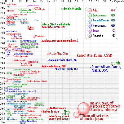
For those which occurred before the development and deployment of seismographs – starting around 1900 – magnitudes are estimated from historical reports of the extent and severity of damage.[28]
| Rank | Date | Location | Event | Magnitude |
|---|---|---|---|---|
| 1 | May 22, 1960 | Valdivia, Chile | 1960 Valdivia earthquake | 9.4–9.6 |
| 2 | March 27, 1964 | Prince William Sound, Alaska, United States | 1964 Alaska earthquake | 9.2–9.3[29] |
| 3 | December 26, 2004 | Sumatra, Indonesia | 2004 Indian Ocean earthquake | 9.2–9.3[30][31] |
| 4 | March 11, 2011 | Pacific Ocean, Tōhoku region, Japan | 2011 Tōhoku earthquake | 9.0–9.1[32][33] |
| 5 | November 4, 1952 | Kamchatka, Russian SFSR, Soviet Union | 1952 Severo-Kurilsk earthquake | 9.0 |
| 6 | January 31, 1906 | Ecuador – Colombia | 1906 Ecuador–Colombia earthquake | 8.8 |
| 7 | February 27, 2010 | Maule, Chile | 2010 Chile earthquake | 8.8 |
| 8 | February 3, 1965 | Rat Islands, Alaska, United States | 1965 Rat Islands earthquake | 8.7 |
| 9 | August 15, 1950 | Assam, India – Tibet, China | 1950 Assam–Tibet earthquake | 8.6–8.7[34] |
| 10 | April 1, 1946 | Aleutian Islands, Alaska, United States | 1946 Aleutian Islands earthquake | 8.6 |
| 11 | March 28, 2005 | Sumatra, Indonesia | 2005 Nias–Simeulue earthquake | 8.6 |
| 12 | March 9, 1957 | Andreanof Islands, Alaska, United States | 1957 Andreanof Islands earthquake | 8.6 |
| 13 | April 11, 2012 | Sumatra, Indonesia | 2012 Indian Ocean earthquakes | 8.6 |
| 14 | November 10, 1922 | Atacama, Chile | 1922 Vallenar earthquake | 8.5–8.6 |
| 15 | February 1, 1938 | Banda Sea, Indonesia (then part of the Dutch East Indies) | 1938 Banda Sea earthquake | 8.5–8.6 |
| 16 | October 13, 1963 | Kuril Islands, Russian SFSR, Soviet Union | 1963 Kuril Islands earthquake | 8.5 |
Pre-instrumental earthquakes
| Date | Location | Event | Magnitude |
|---|---|---|---|
| July 8, 1730 |  Valparaiso, Chile (then part of the Spanish Empire) Valparaiso, Chile (then part of the Spanish Empire) | 1730 Valparaíso earthquake | 9.1–9.3 (est.)[35] |
| October 17, 1737 | Kamchatka Peninsula, Russian Empire | 1737 Kamchatka earthquake | 9.0–9.3 (est.) |
| November 17, 1837 | Valdivia, Chile | 1837 Valdivia earthquake | 8.8–9.5 (est.)[36] |
| December 16, 1575 | Valdivia, Chile (then part of the Spanish Empire) | 1575 Valdivia earthquake | 9.0 (est.) |
| November 24, 1604 | Arica, Chile (then part of the Spanish Empire) | 1604 Arica earthquake | 9.0 (est.) |
| October 28, 1707 |  Pacific Ocean, Shikoku region, Japan Pacific Ocean, Shikoku region, Japan | 1707 Hōei earthquake | 8.7–9.3 (est.) [37] |
| November 25, 1833 | Sumatra, Indonesia (then part of the Dutch East Indies) | 1833 Sumatra earthquake | 8.8–9.2 (est.) |
| May 17, 1841 | Kamchatka, Russian Empire | 1841 Kamchatka earthquake | 9.0 (est.) |
| January 26, 1700 |  Pacific Ocean, US and Canada (then claimed by the Spanish Empire and the British Empire) Pacific Ocean, US and Canada (then claimed by the Spanish Empire and the British Empire) | 1700 Cascadia earthquake | 8.7–9.2 (est.) |
| August 13, 1868 | Arica, Chile (then Peru) | 1868 Arica earthquake | 8.5–9.3 (est.) |
| July 13, 869 | Pacific Ocean, Tōhoku region, Japan | 869 Jōgan earthquake | 8.6–9.0 (est.) |
| November 26, 1852 | Banda Islands, Indonesia (then part of the Dutch East Indies) | 1852 Banda Sea earthquake | 8.8 (est.)[38] |
| May 9, 1877 | Iquique, Chile (then Peru) | 1877 Iquique earthquake | 8.7–8.9 (est.) |
| November 1, 1755 |  Atlantic Ocean, Lisbon, Portugal Atlantic Ocean, Lisbon, Portugal | 1755 Lisbon earthquake | 8.5–9.0 (est.) |
| October 20, 1687 | Lima, Peru (then part of the Spanish Empire) | 1687 Peru earthquake | 8.7 (est.) |
| October 28, 1746 | 1746 Lima–Callao earthquake | 8.6–8.8 (est.) | |
| April 2, 1762 |  Chittagong, Bangladesh (then Kingdom of Mrauk U) Chittagong, Bangladesh (then Kingdom of Mrauk U) | 1762 Arakan earthquake | 8.5–8.8 (est.) |
| September 20, 1498 | Pacific Ocean, Chūbu region, Japan | 1498 Meiō earthquake | 8.6 (est.) |
| March 28, 1787 | Oaxaca, Mexico (then part of the Spanish Empire) | 1787 New Spain earthquake | 8.6 (est.) |
| February 2, 1816 | Atlantic Ocean, Lisbon, Portugal | 1816 North Atlantic earthquake | 8.6 (est.) |
| July 21, 365 |  Mediterranean Sea, Crete, Greece Mediterranean Sea, Crete, Greece | 365 Crete earthquake | 8.5+ (est.) |
| August 24, 1356 | Atlantic Ocean, Lisbon, Portugal | 1356 Lisbon earthquake [pt] | 8.5 (est.) |
| June 6, 1505 |  Himalayas, northern Nepal Himalayas, northern Nepal | 1505 Lo Mustang earthquake | 8.2–8.8 (est.) |
| May 13, 1647 | Santiago, Chile (then part of the Spanish Empire) | 1647 Santiago earthquake | 8.5 (est.) |
| July 25, 1668 |  Shandong, China Shandong, China | 1668 Shandong earthquake | 8.5 (est.)[39] |
| May 24, 1751 | Concepción, Chile (then part of the Spanish Empire) | 1751 Concepción earthquake | 8.5 (est.) |
| March 31, 1761 | Atlantic Ocean, Lisbon, Portugal | 1761 Lisbon earthquake | 8.5 (est.)[40] |
| April 4, 1819 | Copiapó, Chile | 1819 Copiapó earthquake | 8.5 (est.)[36] |
| November 19, 1822 | Valparaíso, Chile | 1822 Valparaíso earthquake | 8.5 (est.) |
| February 20, 1835 | Concepción, Chile | 1835 Concepción earthquake | 8.5 (est.) |
| February 8, 1843 |  Guadeloupe region, Lesser Antilles Guadeloupe region, Lesser Antilles | 1843 Guadeloupe earthquake | 8.5 (est.)[41] |
| February 16, 1861 | Sumatra, Indonesia (then part of the Dutch East Indies) | 1861 Sumatra earthquake | 8.5 (est.) |
| June 15, 1896 | Pacific Ocean, Tōhoku region, Empire of Japan | 1896 Sanriku earthquake | 8.5 (est.) |
Largest earthquakes by country/territory
- This list is a work in progress. Information is likely to be changed.
- The list refers to current country boundaries rather than those at the date of the earthquake.
- Please note, multiple countries could have the same earthquake listed, such as the 1906 Ecuador–Colombia earthquake being listed for both Ecuador and Colombia.
- Unless otherwise noted, magnitudes are reported on the Moment magnitude scale (Mw).
| Country/Territory | Magnitude | Date | More information |
|---|---|---|---|
 Afghanistan Afghanistan | 7.8 | November 15, 1921 | [42] |
| 7.5 Ms | June 14, 1893 | [43] | |
 Algeria Algeria | 7.1 | October 10, 1980 | 1980 El Asnam earthquake |
 American Samoa American Samoa | 6.4 | October 11, 1944 | [44] |
 Andorra Andorra | 6.7 Me | February 2, 1428 | 1428 Catalonia earthquake |
 Angola Angola | 6.0 | May 24, 1914 | [45] |
 Anguilla Anguilla | 6.3 | February 16, 1906 | [46] |
| Antarctica | 8.1 | March 25, 1998 | 1998 Balleny Islands earthquake |
 Antigua and Barbuda Antigua and Barbuda | 8.0 Ms | April 16, 1690 | [47] |
 Argentina Argentina | 7.5 [[[Seismic magnitude scales#Mw|Mw]] | November 23, 1977 | 1977 San Juan earthquake |
 Armenia Armenia | 6.8 Ms | December 7, 1988 | 1988 Armenian earthquake |
| Australia | 8.1 | December 23, 2004 | 2004 Tasman Sea earthquake |
 Austria Austria | 5.6–6.5 | September 15, 1590 | 1590 Neulengbach earthquake |
 Azerbaijan Azerbaijan | 7.0–7.3 | September 30, 1139 | 1139 Ganja earthquake |
 Bangladesh Bangladesh | 8.5–8.8 | April 2, 1762 | 1762 Arakan earthquake |
 Barbados Barbados | 6.5 | February 18, 2014 & July 16, 2015 | [48][49] |
 Belgium Belgium | 6.0–6.5 Ms | September 18, 1692 | 1692 Northwestern Europe earthquake |
 Belize Belize | 4.7 mb | June 28, 1985 | [50] |
 Benin Benin | 4.4 mb | September 11, 2009 | [51] |
 Bhutan Bhutan | 7.6–8.6 | May 4, 1714 | 1714 Bhutan earthquake |
 Bolivia Bolivia | 8.2 | June 9, 1994 | 1994 Bolivia earthquake |
 Bosnia and Herzegovina Bosnia and Herzegovina | 6.1 | October 27, 1969 | 1969 Banja Luka earthquake |
 Botswana Botswana | 6.7 ML | October 11, 1952 | [52] |
 Brazil Brazil | 7.6 | November 9, 1963 | [53] |
 British Indian Ocean Territory British Indian Ocean Territory | 7.3 | November 30, 1983 | 1983 Chagos Archipelago earthquake |
 Brunei Brunei | 5.2 mb | February 22, 1992 | [54] |
 Bulgaria Bulgaria | 7.2 | March 31, 1901 & April 4, 1904 | 1901 Black Sea earthquake & 1904 Kresna earthquakes |
 Burundi Burundi | 5.4 | October 30, 1966 | [55] |
 Cameroon Cameroon | 5.9 | September 12, 1945 | [56] |
 Canada Canada | 8.7–9.2 | January 26, 1700 | 1700 Cascadia earthquake |
 Cape Verde Cape Verde | 6.5 | August 15, 1941 | [57] |
| Caribbean Netherlands | 5.2 | March 10, 2017 | [58] |
 Cayman Islands Cayman Islands | 7.7 | January 28, 2020 | 2020 Caribbean earthquake |
 Central African Republic Central African Republic | 4.9 mb | February 6, 1994 | [59] |
| Chile | 9.4–9.6 | May 22, 1960 | 1960 Valdivia earthquake |
| China | 8.6 | August 15, 1950 | 1950 Assam–Tibet earthquake |
 Cocos Islands Cocos Islands | 7.9 | June 18, 2000 | [60] |
| Colombia | 8.8 | January 31, 1906 | 1906 Ecuador–Colombia earthquake |
 Comoros Comoros | 6.2 | August 23, 1918 | [61] |
 Congo Congo | 5.2 | April 26, 1998 | [62] |
| Costa Rica | 7.7 | April 22, 1991 | 1991 Limon earthquake |
 Croatia Croatia | 6.7 | July 2, 1898 | 1898 Trilj earthquake |
 Cuba Cuba | 7.1 | February 20, 1917 | [63] |
 Cyprus Cyprus | 7.0–7.5 | May 11, 1222 | 1222 Cyprus earthquake |
 Czech Republic Czech Republic | 4.8 ML | December 23, 1985 | [64] |
 Democratic Republic of the Congo Democratic Republic of the Congo | 6.9 | December 13, 1910 | [65] |
 Denmark Denmark | 4.4 mb | February 19, 2010 | [66] |
 Djibouti Djibouti | 6.5 | August 20, 1989 | [67] |
 Dominica Dominica | 6.4 | January 8, 1959 | [68] |
 Dominican Republic Dominican Republic | 7.8 | August 4, 1946 | 1946 Dominican Republic earthquake |
 East Timor East Timor | 7.2 | September 29, 1905 | [69] |
 Ecuador Ecuador | 8.8 | January 31, 1906 | 1906 Ecuador–Colombia earthquake |
 Egypt Egypt | 7.3 | November 22, 1995 | 1995 Gulf of Aqaba earthquake |
| El Salvador | 8.0 MI | December 19, 1862 | [70] |
 Equatorial Guinea Equatorial Guinea | 4.9 mb | March 28, 1999 | [71] |
 Eritrea Eritrea | 6.6 | December 28, 1977 | [72] |
 Estonia Estonia | 4.5–4.7 mb | October 25, 1976 | Osmussaar earthquake |
 Eswatini Eswatini | 4.4 mb | August 4, 1987 | [73] |
 Ethiopia Ethiopia | 6.5 | August 25, 1906 | [74] |
| Fiji | 8.2 | August 19, 2018 | 2018 Fiji earthquakes |
 Finland Finland | 4.7 Muk | November 4, 1898 | [75] |
| France | 6.4–6.5 Muk | January 25, 1799 | 1799 Vendée earthquake |
| French Guiana | 6.9 | August 4, 1885 | [76] |
 French Polynesia French Polynesia | 5.6 | March 6, 1965 | [77] |
 Gabon Gabon | 6.0 | September 23, 1974 | [78] |
 Georgia Georgia | 7.0 | April 29, 1991 | 1991 Racha earthquake |
 Germany Germany | 6.4 ML | February 18, 1756 | 1756 Düren earthquake |
 Ghana Ghana | 6.4 | June 22, 1939 | [79] |
| Greece | 8.5+ | July 21, 365 | 365 Crete earthquake |
 Greenland Greenland | 7.4 | November 20, 1933 | 1933 Baffin Bay earthquake |
 Grenada Grenada | 7.0 Ms | December 3, 1831 | [80] |
| Guadeloupe | 8.5 Muk | February 8, 1843 | 1843 Guadeloupe earthquake |
| Guam | 7.8 | August 8, 1993 | 1993 Guam earthquake |
 Guatemala Guatemala | 7.7 | August 6, 1942 | 1942 Guatemala earthquake |
 Guinea Guinea | 6.3 | December 22, 1983 | 1983 Guinea earthquake |
 Guyana Guyana | 5.5 | January 31, 2021 | [81] |
 Haiti Haiti | 8.1 Ms | May 7, 1842 | 1842 Cap-Haïtien earthquake |
 Honduras Honduras | 7.5 | January 10, 2018 | 2018 Swan Islands earthquake |
 Hong Kong Hong Kong | 3.8 ML | January 5, 2020 | [82] |
 Hungary Hungary | 6.2–6.5 | June 28, 1763 | 1763 Komárom earthquake |
| 7.0 | January 22, 1910 | [83] | |
| India | 8.6 | August 15, 1950 | 1950 Assam–Tibet earthquake |
| Indonesia | 9.2–9.3 | December 26, 2004 | 2004 Indian Ocean earthquake |
 Iran Iran | 7.9 Ms | December 22, 856 | 856 Damghan earthquake |
 Iraq Iraq | 7.0 | September 22, 1666 | [84] |
 Ireland Ireland | 4.0 ML | June 6, 2012 | [85] |
| 7.3 | December 5, 1033 | 1033 Jordan Rift Valley earthquake | |
 Italy Italy | 7.4 | January 11, 1693 | 1693 Sicily earthquake |
 Jamaica Jamaica | 7.7 | January 28, 2020 | 2020 Caribbean earthquake |
| Japan | 9.0–9.1 | March 11, 2011 | 2011 Tōhoku earthquake |
 Jersey Jersey | 5.4 | July 30, 1926 | [86] |
 Jordan Jordan | 7.3 | December 5, 1033 | 1033 Jordan Rift Valley earthquake |
 Kazakhstan Kazakhstan | 8.0 | July 11, 1889 & January 3, 1911 | 1889 Chilik earthquake & 1911 Kebin earthquake |
 Kenya Kenya | 6.7 | January 6, 1928 | [87] |
 Kiribati Kiribati | 5.9 mb | May 23, 1982 | [88] |
| 6.1 ML | February 26, 1755 & August 10, 1921 | [89] | |
 Kuwait Kuwait | 4.7 mb | June 2, 1993 & November 11, 2020 | [90][91] |
 Kyrgyzstan Kyrgyzstan | 8.0 | July 11, 1889 & January 3, 1911 | 1889 Chilik earthquake & 1911 Kebin earthquake |
 Laos Laos | 6.7 | December 22, 1925 | [92] |
 Lebanon Lebanon | 7.5 | July 9, 551 | 551 Beirut earthquake |
 Liberia Liberia | 4.5 mb | November 25, 1995 | [93] |
 Libya Libya | 6.8 | April 19, 1935 | [94] |
 Liechtenstein Liechtenstein | 3.6 | December 12, 2013 | [95] |
 Luxembourg Luxembourg | 2.9 ML | September 3, 1986 | [96] |
 Madagascar Madagascar | 6.2 | July 4, 1919 | [97] |
 Malawi Malawi | 6.3 | March 10, 1989 | 1989 Malawi earthquake |
 Malaysia Malaysia | 6.6 | August 11, 1923 | [98] |
 Maldives Maldives | 7.4 | February 29, 1944 | [99] |
 Mali Mali | 4.2 mb | January 11, 1999 | [100] |
 Malta Malta | 5.5 | April 21, 2023 | [101] |
 Marshall Islands Marshall Islands | 5.7 | March 22, 1982 | [102] |
 Martinique Martinique | 7.5–8.0 | January 11, 1839 | 1839 Martinique earthquake |
 Mauritania Mauritania | 4.6 mb | September 3, 1993 & March 1, 2012 | [103][104] |
 Mauritius Mauritius | 6.4 | June 19, 1976 | [105] |
| Mayotte | 5.9 | May 15, 2018 | [106] |
| Mexico | 8.6 | March 28, 1787 | 1787 New Spain earthquake |
 Micronesia Micronesia | 7.8 | August 16, 1911 | [107] |
 Moldova Moldova | 3.9 mb | April 2, 1988 | [108] |
 Monaco Monaco | 6.3 | July 19, 1963 | [109] |
 Mongolia Mongolia | 8.3 | July 23, 1905 | 1905 Bolnai earthquake |
 Montenegro Montenegro | 6.9 | April 15, 1979 | 1979 Montenegro earthquake |
 Morocco Morocco | 6.8 | November 27, 1755 & September 8, 2023 | 1755 Meknes earthquake & 2023 Al Haouz earthquake |
 Mozambique Mozambique | 7.0 | February 22, 2006 | 2006 Mozambique earthquake |
 Myanmar Myanmar | 8.5–8.8 | April 2, 1762 | 1762 Arakan earthquake |
 Namibia Namibia | 5.4 | April 4, 2021 | [110] |
| Nepal | 8.2–8.8 | June 6, 1505 | 1505 Lo Mustang earthquake |
| Netherlands | 5.3 | April 13, 1992 | 1992 Roermond earthquake |
 New Caledonia New Caledonia | 7.9 | August 9, 1901 | [111] |
| New Zealand | 8.2 | January 23, 1855 & May 1, 1917 | 1855 Wairarapa earthquake[112] |
 Nicaragua Nicaragua | 7.7 | September 2, 1992 | 1992 Nicaragua earthquake |
 Niger Niger | 4.6 mb | January 18, 2017 | [113] |
 Nigeria Nigeria | 4.5 mb | March 7, 2000 | [114] |
 North Korea North Korea | 7.7 | September 29, 1973 | [115] |
 North Macedonia North Macedonia | 6.7 | March 8, 1931 | [116] |
 Northern Mariana Islands Northern Mariana Islands | 7.7 | December 28, 1940 & July 29, 2016 | [117][118] |
| 6.8 | August 30, 2012 | [119] | |
 Oman Oman | 5.7 | March 30, 1966 | [120] |
 Pakistan Pakistan | 8.1 | November 28, 1945 | 1945 Balochistan earthquake |
 Palau Palau | 6.5 | May 31, 1982 | [121] |
 Palestine Palestine | 7.3 | December 5, 1033 | 1033 Jordan Rift Valley earthquake |
 Panama Panama | 7.9–8.3 Ms | September 7, 1882 | 1882 Panama earthquake |
| Papua New Guinea | 8.2 | May 6, 1919 | [122] |
 Paraguay Paraguay | 6.5 | February 28, 1989 | [123] |
| Peru (now part of present-day Chile) | 8.5–9.3 | August 13, 1868 | 1868 Arica earthquake |
| Philippines | 8.3 | August 15, 1918 | 1918 Celebes Sea earthquake |
 Poland Poland | 5.6 | December 3, 1786 | [124] |
 Portugal Portugal | 8.5–9.0 | November 1, 1755 | 1755 Lisbon earthquake |
 Puerto Rico Puerto Rico | 8.0 | May 2, 1787 | 1787 Boricua earthquake |
 Romania Romania | 7.9 | October 26, 1802 | 1802 Vrancea earthquake |
| Russia | 9.0–9.3 | October 16, 1737 | 1737 Kamchatka earthquake |
 Rwanda Rwanda | 5.9 | February 3, 2008 | 2008 Lake Kivu earthquake |
| Saint Barthélemy | 5.4 | November 18, 1990 | [125] |
 Saint Kitts and Nevis Saint Kitts and Nevis | 6.5 | March 16, 1985 | [126] |
 Saint Lucia Saint Lucia | 7.3 | March 19, 1953 | [127] |
| Saint Martin | 5.0 | July 4, 2012 | [128] |
| Saint Pierre and Miquelon | 7.2 | November 18, 1929 | 1929 Grand Banks earthquake |
 Saint Vincent and the Grenadines Saint Vincent and the Grenadines | 6.1 | July 6, 1940 | [129] |
| Samoa | 8.3–8.5 | June 25, 1917 | 1917 Samoa earthquake |
 São Tomé and Príncipe São Tomé and Príncipe | 5.5 | December 19, 2019 | [130] |
 Saudi Arabia Saudi Arabia | 7.3 | November 22, 1995 | 1995 Gulf of Aqaba earthquake |
 Senegal Senegal | 5.5 | May 21, 1986 | [131] |
 Serbia Serbia | 6.0 | May 15, 1927 | [132] |
 Seychelles Seychelles | 5.2 mb | April 28, 1995 | [133] |
 Slovakia Slovakia | 6.2–6.5 | June 28, 1763 | 1763 Komárom earthquake |
 Slovenia Slovenia | 6.1 ML | April 14, 1895 | 1895 Ljubljana earthquake |
| Solomon Islands | 8.1 | April 1, 2007 | 2007 Solomon Islands earthquake |
 Somalia Somalia | 6.0 | January 22, 1929 | [134] |
 South Africa South Africa | 6.8 | December 31, 1932 | [135] |
 South Georgia and the South Sandwich Islands South Georgia and the South Sandwich Islands | 8.1–8.3 | August 12, 2021 | 2021 South Sandwich Islands earthquakes |
 South Korea South Korea | 7.5 | June 26, 1681 | 1681 Yangyang earthquake [ko] |
 South Sudan South Sudan | 7.2 | May 20, 1990 | 1990 South Sudan earthquakes |
 Spain Spain | 7.8 | March 29, 1954 | [136] |
 Sri Lanka Sri Lanka | 5.7 | August 30, 1973 | [137] |
 Sudan Sudan | 6.0 | May 12, 1938 | [138] |
 Switzerland Switzerland | 6.0–7.1 | October 18, 1356 | 1356 Basel earthquake |
 Syria Syria | 7.6 Ms | May 20, 1202 | 1202 Syria earthquake |
| Taiwan | 8.2 | June 5, 1920 | 1920 Hualien earthquake |
 Tajikistan Tajikistan | 7.5 | July 10, 1949 | 1949 Khait earthquake |
 Tanzania Tanzania | 7.0 | July 8, 1919 | [139] |
 Thailand Thailand | 6.1 | May 5, 2014 | 2014 Mae Lao earthquake |
 Tonga Tonga | 8.3–8.5 | June 25, 1917 | 1917 Samoa earthquake |
 Trinidad and Tobago Trinidad and Tobago | 7.5 Mfa | January 10, 1888 | [140] |
 Tunisia Tunisia | ≤7.2 | October 9, 859 | [141] |
| Turkey | 7.8–8.0 Ms | August 17, 1668 | 1668 North Anatolia earthquake |
 Turkmenistan Turkmenistan | 8.2 Ms | July 7, 1895 | [142] |
 Tuvalu Tuvalu | 5.4 Mw | February 5, 1983 | [143] |
 Uganda Uganda | 6.5 | June 30, 1952 | [144] |
 Ukraine Ukraine | 6.7 | September 11, 1927 | 1927 Crimean earthquakes |
 United Arab Emirates United Arab Emirates | 5.0 | March 11, 2002 | [145] |
 United Kingdom United Kingdom | 6.1 ML | June 7, 1931 | 1931 Dogger Bank earthquake |
| United States | 9.25 | June 11, 1585 | 1585 Aleutian Islands earthquake |
 U.S. Virgin Islands U.S. Virgin Islands | 7.2 | November 18, 1867 | 1867 Virgin Islands earthquake and tsunami |
 Uruguay Uruguay | 5.5 Ms | June 5, 1888 | 1888 Río de la Plata earthquake |
 Uzbekistan Uzbekistan | 7.4 Ms | October 21, 1907 | 1907 Qaratog earthquake |
 Vanuatu Vanuatu | 8.1 | September 20, 1920 | [146] |
 Venezuela Venezuela | 7.6–7.7 Mw | April 29, 1894 & October 29, 1900 | 1900 San Narciso earthquake & 1894 Venezuelan earthquake[147] |
 Vietnam Vietnam | 6.8 | November 1, 1935 | [148] |
| Wallis and Futuna | 7.6 | May 23, 1956 | [149] |
 Yemen Yemen | 6.7 | December 18, 1908 | [150] |
 Zambia Zambia | 6.5 | May 1, 1919 | [151] |
 Zimbabwe Zimbabwe | 5.5 | September 25, 1963 | [152] |
Costliest earthquakes
This is the top ten major earthquakes by the dollar value of property (public and private) losses directly attributable to the earthquake.
| Rank | Event | Location | Magnitude | Property damage |
|---|---|---|---|---|
| 1 | 2011 Tōhoku earthquake and tsunami | Japan | 9.1 | $360 billion[153][154] |
| 2 | 1995 Great Hanshin earthquake | Japan | 6.9 | $200 billion[155] |
| 3 | 2023 Turkey–Syria earthquakes | Turkey Syria | 7.8 | $163.6 billion[156][157] |
| 4 | 2008 Sichuan earthquake | China | 7.9 | $150 billion[158] |
| 5 | 2011 Christchurch earthquake | New Zealand | 6.3 | $40 billion[159] |
| 6 | 2004 Chūetsu earthquake | Japan | 6.6 | $28 billion[160][161] |
| 7 | 2011 Sikkim earthquake | India | 6.9 | $22.3 billion[162] |
| 8 | 1999 İzmit earthquake | Turkey | 7.6 | $20 billion[160] |
| 9 | 2009 L'Aquila earthquake | Italy | 6.3 | $16 billion[163] |
| 10 | 2012 Northern Italy earthquakes | Italy | 6.1 | $15.8 billion[164] |
Deadliest earthquakes
The following is a summary list of earthquakes with over approximately 100,000 deaths. The 893 Ardabil earthquake probably relate to the 893 Dvin earthquake, due to misreading of the Arabic word for Dvin, 'Dabil' as 'Ardabil'.[165] This is regarded as a 'fake earthquake'.[166]
| Rank | Event | Date | Location | Fatalities | Magnitude | Notes |
|---|---|---|---|---|---|---|
| 1 | 1976 Tangshan earthquake | July 28, 1976 | Hebei, China | 242,769–700,000+ | 7.6 | Official casualty figure is 242,769 deaths. Estimated death toll as high as 655,000. 799,000 injured.[168][169] |
| 2 | 1920 Haiyuan earthquake | December 16, 1920 |  Ningxia–Gansu, China Ningxia–Gansu, China | 273,400 | 7.8 | Previously cited death toll was 230,000 and this fugure was revised in 2010.[170][171] |
| 3 | 526 Antioch earthquake | May 21, 526 |  Antioch, Byzantine Empire (modern-day Turkey) Antioch, Byzantine Empire (modern-day Turkey) | 250,000[172] | 7.0[173] | Procopius (II.14.6), sources based on John of Ephesus. |
| 4 | 1139 Ganja earthquake | September 30, 1139 | Ganja, Seljuk Empire (modern-day Azerbaijan) | 230,000–300,000[174] | 7.0 Mw | Death toll may have been a historical conflation with earthquakes on November 1137 in the Jazira plain and the 1138 Aleppo earthquake.[175] |
| 5 | 2004 Indian Ocean earthquake and tsunami | December 26, 2004 | Sumatra, Indonesia | 227,898 | 9.1–9.3 | Death toll includes those missing and presumed dead.[174] |
| 6 | 1138 Aleppo earthquake | October 11, 1138 | Aleppo, Seljuk Empire (modern-day Syria) | 130,000–230,000[176] | 7.1[176] | The figure of 230,000 dead is based on a historical conflation of this earthquake with earthquakes in November 1137 on the Jazira plain and the 1139 Ganja earthquakein the Azerbaijani city of Ganja. The first mention of a 230,000 death toll was by Ibn Taghribirdi in the fifteenth century.[175] |
| 7 | 2010 Haiti earthquake | January 12, 2010 | Haiti | 100,000–316,000 | 7.0 | Estimates vary from 316,000 (Haitian government) to 222,570 (UN OCHA estimate)[177] to 158,000 (Medicine, Conflict and Survival) to between 85,000 and 46,000 (report commissioned by USAID).[178][179] |
| 8 | 1303 Hongdong earthquake | July 25, 1303 | Shanxi, Yuan dynasty (modern-day China) | 200,000[180] | 8.0 | Taiyuan and Pingyang were leveled. |
| 9 | 856 Damghan earthquake | December 22, 856 | Damghan, Abbasid Caliphate (modern-day Iran) | 200,000 | 7.9 Ms | |
| 10 | 533 Aleppo earthquake | November 29, 533 | Aleppo, Byzantine Empire (modern-day Syria) | 130,000[181] | Unknown | |
| 11 | 1948 Ashgabat earthquake | October 6, 1948 |  Ashgabat, Turkmen SSR (modern-day Turkmenistan) Ashgabat, Turkmen SSR (modern-day Turkmenistan) | 110,000 | 7.3 Ms | Previously cited death toll was 10,000 until a news release on December 9, 1988 advised that the correct death toll was 110,000.[174] |
| 12 | 1923 Great Kantō earthquake | September 1, 1923 | Kantō region, Japan | 105,385[182] | 7.9 | This earthquake with an epicenter beneath Izu Ōshima Island in Sagami Bay, shook the Kantō plain on the Japanese island of Honshū at 11:58 am. Shaking duration reported between 4 and 10 minutes, devastating Tokyo, Yokohama, Chiba, Kanagawa, and Shizuoka.[183] Shaking slid the 93-ton Great Buddha statue at Kamakura almost 2 feet (0.61 m) forward. Casualty estimates range from 100,000 to 142,800, the latter figure including ≈40,000 missing later presumed dead. |
| 13 | 1556 Shaanxi earthquake | January 23, 1556 | Shaanxi, China | 100,000+ | 8.0 | Direct deaths thought to be just over 100,000 while about 730,000 people died from famines or migrated elsewhere.[184][185][186][187] |
| 14 | 1290 Zhili earthquake | September 27, 1290 | Ningcheng, Yuan dynasty (modern-day China) | 100,000 | 6.8 Ms | Estimates also suggests lower values of at least 7,000.[188] |
Most studied earthquakes
The 50 most studied earthquakes according to the International Seismological Centre (ISC), based on a count of scientific papers (mostly in English) that discuss that earthquake. The "Event #" is linked to the ISC Event Bibliography for that event.
| Rank | Event origin time | ISC Event # | Papers | ISC code | Event |
|---|---|---|---|---|---|
| 1 | 2011-03-11 05:46:23 | 16461282 | 1992 | TOHOKU2011 | 2011 Tōhoku earthquake and tsunami |
| 2 | 2008-05-12 06:28:00 | 13228121 | 1641 | WENCHUAN2008 | 2008 Sichuan earthquake |
| 3 | 2004-12-26 00:58:52 | 7453151 | 948 | SUMATRA2004 | 2004 Indian Ocean earthquake and tsunami |
| 4 | 1999-09-20 17:47:16 | 1718616 | 753 | CHI-CHI1999 | 1999 Jiji earthquake |
| 5 | 1995-01-16 20:46:51 | 124708 | 536 | SHYOGO1995 | Great Hanshin earthquake |
| 6 | 1994-01-17 12:30:54 | 189275 | 530 | NORTHRIDGE1994 | 1994 Northridge earthquake |
| 7 | 2010-02-27 06:34:13 | 14340585 | 515 | MAULE2010 | 2010 Chile earthquake |
| 8 | 2009-04-06 01:32:42 | 13438018 | 511 | LAQUILA2009 | 2009 L'Aquila earthquake |
| 9 | 1989-10-18 00:04:14 | 389808 | 508 | LOMAPRIETA1989 | 1989 Loma Prieta earthquake |
| 10 | 2015-04-25 06:11:26 | 607208674 | 488 | GORKHA2015 | April 2015 Nepal earthquake |
| 11 | 1992-06-28 11:57:35 | 289086 | 429 | LANDERS1992 | 1992 Landers earthquake |
| 12 | 1999-08-17 00:01:38 | 1655218 | 415 | IZMIT1999 | 1999 İzmit earthquake |
| 13 | 2016-04-15 16:25:06 | 610289055 | 339 | KUMAMOTO2016 | 2016 Kumamoto earthquakes |
| 14 | 1964-03-28 03:36:13 | 869809 | 327 | ALASKA1964 | 1964 Alaska earthquake |
| 15 | 2013-04-20 00:02:47 | 607304721 | 307 | LUSHAN2013 | 2013 Lushan earthquake |
| 16 | 1960-05-22 19:11:20 | 879136 | 280 | VALDIVIA1960 | 1960 Valdivia earthquake |
| 17 | 2010-09-03 16:35:46 | 15155483 | 251 | DARFIELD2010 | 2010 Canterbury earthquake |
| 18 | 2001-01-26 03:16:40 | 1763683 | 251 | BHUJ2001 | 2001 Gujarat earthquake |
| 19 | 1985-09-19 13:17:50 | 516095 | 249 | MEXICOCITY1985 | 1985 Mexico City earthquake |
| 20 | 2016-08-24 01:36:33 | 611462212 | 248 | AMATRICE2016 | August 2016 Central Italy earthquake |
| 21 | 1971-02-09 14:00:40 | 787038 | 241 | SANFERNANDO1971 | 1971 San Fernando earthquake |
| 22 | 1976-07-27 19:42:53 | 711732 | 232 | TANGSHAN1976 | 1976 Tangshan earthquake |
| 23 | 2016-11-13 11:02:59 | 615035032 | 228 | KAIKOURA2016 | 2016 Kaikōura earthquake |
| 24 | 2003-09-25 19:50:07 | 7134409 | 221 | TOKACHI-OKI2003 | 2003 Tokachi earthquake |
| 25 | 1980-11-23 18:34:52 | 635924 | 210 | IRPINIA1980 | 1980 Irpinia earthquake |
| 26 | 2004-10-23 08:55:58 | 7421058 | 203 | MID-NIIGATA2004 | 2004 Chūetsu earthquake |
| 27 | 1976-05-06 20:00:12 | 713583 | 198 | FRIULI1976 | 1976 Friuli earthquake |
| 28 | 2012-05-20 02:03:53 | 601025379 | 197 | EMILIA2012A | 2012 Northern Italy earthquakes |
| 29 | 2011-02-21 23:51:42 | 16168897 | 197 | CHRISTCHURCH2011A | 2011 Christchurch earthquake |
| 30 | 2019-07-06 03:19:55 | 616203758 | 194 | RIDGECREST2019B | 2019 Ridgecrest earthquakes |
| 31 | 2005-03-28 16:09:35 | 7486110 | 192 | NIAS2005 | 2005 Nias–Simeulue earthquake |
| 32 | 2004-09-28 17:15:24 | 7406045 | 191 | PARKFIELD2004 | Parkfield earthquake |
| 33 | 2016-10-30 06:40:19 | 609624987 | 183 | NORCIA2016 | October 2016 Central Italy earthquakes |
| 34 | 1999-10-16 09:46:45 | 1643776 | 179 | HECTOR-MINE1999 | 1999 Hector Mine earthquake |
| 35 | 2005-10-08 03:50:37 | 7703077 | 171 | KASHMIR2005 | 2005 Kashmir earthquake |
| 36 | 2001-11-14 09:26:12 | 2331800 | 170 | KUNLUN2001 | 2001 Kunlun earthquake |
| 37 | 1923-09-01 02:58:35 | 911526 | 170 | KANTO1923 | 1923 Great Kantō earthquake |
| 38 | 2022-01-15 04:14:45 | 621831271 | 169 | HUNGATONGAHUNGAAPAI2022 | 2022 Hunga Tonga–Hunga Haʻapai eruption and tsunami |
| 39 | 1979-10-15 23:16:57 | 657282 | 163 | IMPERIAL1979 | 1979 Imperial Valley earthquake |
| 40 | 2015-09-16 22:54:30 | 611531714 | 161 | ILLAPEL2015 | 2015 Illapel earthquake |
| 41 | 2002-11-03 22:12:41 | 6123395 | 160 | DENALI2002 | 2002 Denali earthquake |
| 42 | 1999-11-12 16:57:19 | 1650092 | 159 | DUZCE1999 | 1999 Düzce earthquake |
| 43 | 2014-04-01 23:46:47 | 610102185 | 154 | IQUIQUE2014 | 2014 Iquique earthquake |
| 44 | 2010-01-12 21:53:10 | 14226221 | 153 | HAITI2010 | 2010 Haiti earthquake |
| 45 | 2017-08-08 13:19:49 | 610874246 | 151 | JUIZHAIGOU2017 | 2017 Jinghe earthquake |
| 46 | 1988-12-07 07:41:24 | 417441 | 151 | ARMENIA1988 | 1988 Armenian earthquake |
| 47 | 2019-07-04 17:33:50 | 616217956 | 150 | RIDGECREST2019A | 2019 Ridgecrest earthquakes |
| 48 | 2003-12-26 01:56:53 | 7217667 | 145 | BAM2003 | 2003 Bam earthquake |
| 49 | 2010-04-04 22:40:43 | 600257057 | 145 | EL-MAYOR-CUCAPAH2010 | 2010 Baja California earthquake |
| 50 | 2012-05-29 07:00:04 | 605482196 | 144 | EMILIA2012B | 2012 Northern Italy earthquakes |
modified from figure 2, "The most studied events", at the ISC's Overview of the ISC Event Bibliography.
International Seismological Centre. Event Bibliography. Thatcham, United Kingdom. 2018.
See also
 Earth sciences portal
- List of deadly earthquakes since 1900
- List of historical earthquakes
- List of natural disasters by death toll
- List of megathrust earthquakes
References
- ^ "22 Mayıs 1971 Bingöl Depremi Ms:6.8". AFAD (in Turkish). Retrieved April 5, 2022.
- ^ "M 6.8 – 32 km E of Uttark?shi, India". earthquake.usgs.gov. Retrieved March 28, 2022.
 This article incorporates text from this source, which is in the public domain.
 - ^ "Today in Earthquake History". earthquake.usgs.gov. Retrieved March 27, 2022. This article incorporates text from this source, which is in the public domain.
- ^ ANSS. "M 7.9 – 103 km S of Bengkulu, Indonesia usp0009txv". Comprehensive Catalog. U.S. Geological Survey.
- ^ ANSS. "M 6.3 - 10 km E of Pundong, Indonesia 2006usp000ej1c". Comprehensive Catalog. U.S. Geological Survey.
- ^ "M 7.6 – 30 km WSW of Pariaman, Indonesia". earthquake.usgs.gov. U.S. Geological Survey. Retrieved January 8, 2022.
- ^ "M 7.8 – 27 km SSE of Muisne, Ecuador". U.S. Geological Survey. Retrieved January 8, 2022.
- ^ ANSS. "M 7.8 – southern Qinghai, China iscgem902908". Comprehensive Catalog. U.S. Geological Survey.
- ^ ANSS. "M 8.1 – 68 km SSW of Gorontalo, Indonesia iscgem902275". Comprehensive Catalog. U.S. Geological Survey.
- ^ ANSS. "M 7.6 – 138 km SW of Insrom, Indonesia iscgem897871". Comprehensive Catalog. U.S. Geological Survey.
- ^ ANSS. "M 7.9 – off the east coast of Honshu, Japan iscgem892187". Comprehensive Catalog. U.S. Geological Survey.
- ^ ANSS. "M 7.8 – Strait of Gibraltar iscgem890481". Comprehensive Catalog. U.S. Geological Survey.
- ^ ANSS. "M 7.5 – Kermadec Islands region iscgem889257". Comprehensive Catalog. U.S. Geological Survey.
- ^ ANSS. "M 7.6 – Peru-Brazil border region iscgem877215". Comprehensive Catalog. U.S. Geological Survey.
- ^ ANSS. "M 7.5 – Fiji region iscgem874777". Comprehensive Catalog. U.S. Geological Survey.
- ^ ANSS. "M 8.2 – Kuril Islands iscgem805430". Comprehensive Catalog. U.S. Geological Survey.
- ^ ANSS. "M 8.0 – Mindanao, Philippines iscgem765501". Comprehensive Catalog. U.S. Geological Survey.
- ^ ANSS. "M 7.9 – 199 km S of Lata, Solomon Islands usp00018y0". Comprehensive Catalog. U.S. Geological Survey.
- ^ ANSS. "M 7.6 - off the west coast of the South Island of New Zealand usp0001fkx". Comprehensive Catalog. U.S. Geological Survey.
- ^ ANSS. "M 7.6 – 157 km ESE of Kokopo, Papua New Guinea usp0001tr1". Comprehensive Catalog. U.S. Geological Survey.
- ^ ANSS. "M 7.6 – 85 km SE of Honiara, Solomon Islands usp00021u71984". Comprehensive Catalog. U.S. Geological Survey.
- ^ ANSS. "1986 M 8.0 – 85 km SSW of Atka, Alaska". Comprehensive Catalog. U.S. Geological Survey.
- ^ ANSS. "1987 M 7.9 – 200km WSW of Yakutat, Alaska". Comprehensive Catalog. U.S. Geological Survey.
- ^ ANSS. "1987 M 7.8 - Gulf of Alaska". Comprehensive Catalog. U.S. Geological Survey.
- ^ "M 8.0, Macquarie Island region". United States Geological Survey. May 23, 1989.
- ^ ANSS. "1997 M 7.8 - 156 km S of Ust'-Kamchatsk Staryy, Russia". Comprehensive Catalog. U.S. Geological Survey.
- ^ "Magnitude 8 and Greater Earthquakes Since 1900". usgs.gov. Archived from the original on April 14, 2016.
- ^ Johnston, Arch C.; Halchuk, Stephen (June–July 1993), "The seismicity data base for the Global Seismic Hazard Assessment Program", Annali di Geofisica, 36 (3–4): 133–151, pp. 140, 142 et seq.
- ^ ANSS. "iscgem869809 M 9.2 - The 1964 Prince William Sound, Alaska Earthquake". Comprehensive Catalog. U.S. Geological Survey.
- ^ Stein, Seth; Okal, Emile A. (January 1, 2007). "Ultralong Period Seismic Study of the December 2004 Indian Ocean Earthquake and Implications for Regional Tectonics and the Subduction Process". Bulletin of the Seismological Society of America. 97 (1A): S279–S295. Bibcode:2007BuSSA..97S.279S. doi:10.1785/0120050617. ISSN 1943-3573.
- ^ Fujii, Yushiro; Satake, Kenji; Watada, Shingo; Ho, Tung-Cheng (December 1, 2021). "Re-examination of Slip Distribution of the 2004 Sumatra–Andaman Earthquake (Mw 9.2) by the Inversion of Tsunami Data Using Green's Functions Corrected for Compressible Seawater Over the Elastic Earth". Pure and Applied Geophysics. 178 (12): 4777–4796. doi:10.1007/s00024-021-02909-6. ISSN 1420-9136.
- ^ Romano, F.; Piatanesi, A.; Lorito, S.; D'Agostino, N.; Hirata, K.; Atzori, S.; Yamazaki, Y.; Cocco, M. (April 27, 2012). "Clues from joint inversion of tsunami and geodetic data of the 2011 Tohoku-oki earthquake". Scientific Reports. 2 (1): 385. Bibcode:2012NatSR...2E.385R. doi:10.1038/srep00385. ISSN 2045-2322. PMC 3338116. PMID 22545193.
- ^ Wang, Zhen; Kato, Teruyuki; Zhou, Xin; Fukuda, Jun’ichi (November 28, 2016). "Source process with heterogeneous rupture velocity for the 2011 Tohoku-Oki earthquake based on 1-Hz GPS data". Earth, Planets and Space. 68 (1): 193. Bibcode:2016EP&S...68..193W. doi:10.1186/s40623-016-0572-4. ISSN 1880-5981.
- ^ ANSS. "official19500815140934_30 M 8.6 - 1950 Assam-Tibet Earthquake". Comprehensive Catalog. U.S. Geological Survey.
- ^ Carvajal, M.; Cisternas, M.; Catalán, P.A. (2017). "Source of the 1730 Chilean earthquake from historical records: Implications for the future tsunami hazard on the coast of Metropolitan Chile". Journal of Geophysical Research: Solid Earth. 122 (5): 3648–3660. Bibcode:2017JGRB..122.3648C. doi:10.1002/2017JB014063. S2CID 133806784.
- ^ a b Jin Junfang; Yin Shuyan; Yan Junping (2014). "Symmetry and tendency judgment of Ms ≥ 8.0 strong earthquakes in Chile". Geodesy and Geodynamics. 5 (1): 34–40. Bibcode:2014G&G.....5...34J. doi:10.3724/SP.J.1246.2014.01034.
- ^ "M 9.3Re-evaluation of Mw of the 1707 Hoei earthquake – near the east coast of Honshu, Japan" (PDF). AIST.
- ^ H. Ringer; J. P. Whitehead; J. Krometis; R. A. Harris; N. Glatt-Holtz; S. Giddens; C. Ashcraft; G. Carver; A. Robertson; M. Harward; J. Fullwood; K. Lightheart; R. Hilton; A. Avery; C. Kesler; M. Morrise; M. H. Klein (2021). "Methodological Reconstruction of Historical Seismic Events From Anecdotal Accounts of Destructive Tsunamis: A Case Study for the Great 1852 Banda Arc Mega-Thrust Earthquake and Tsunami" (PDF). Journal of Geophysical Research: Solid Earth. 126 (4). arXiv:2009.14272. Bibcode:2021JGRB..12621107R. doi:10.1029/2020JB021107. S2CID 222066748. Archived from the original (PDF) on October 9, 2022. Retrieved June 19, 2021.
- ^ "Significant Earthquake Information CHINA: SHANDONG PROVINCE". NGCD. Retrieved December 9, 2020.
- ^ NCEI Global Historical Hazard Database. "Significant Earthquake Information PORTUGAL: LISBON". www.ngdc.noaa.gov. Retrieved February 1, 2021.
- ^ Hough S.E. (2013). "Missing great earthquakes". Journal of Geophysical Research: Solid Earth. 118 (3): 1098–1108. Bibcode:2013JGRB..118.1098H. doi:10.1002/jgrb.50083. S2CID 128458643.
- ^ ANSS. "M 7.8 – 71 km SSW of Jurm, Afghanistan 1909". Comprehensive Catalog. U.S. Geological Survey.
- ^ "Significant Earthquake Information". National Geophysical Data Center / World Data Service: NCEI/WDS Global Historical Tsunami Database. NOAA National Centers for Environmental Information. doi:10.7289/V5TD9V7K. Retrieved June 9, 2024.
- ^ ANSS. "M 6.4 – 188 km SW of Vailoatai, American Samoa 1944". Comprehensive Catalog. U.S. Geological Survey.
- ^ ANSS. "M 6.0 – 67 km N of Sumbe, Angola 1914". Comprehensive Catalog. U.S. Geological Survey.
- ^ ANSS. "M 6.3 – 121 km NNW of The Valley, Anguilla iscgemsup610548626". Comprehensive Catalog. U.S. Geological Survey.
- ^ "Significant Earthquake Information". National Geophysical Data Center / World Data Service: NCEI/WDS Global Historical Tsunami Database. NOAA National Centers for Environmental Information. doi:10.7289/V5TD9V7K. Retrieved June 9, 2024.
- ^ ANSS. "M 6.5 – 171 km NNE of Greenland, Barbados usc000mskt". Comprehensive Catalog. U.S. Geological Survey.
- ^ ANSS. "M 6.5 – 128 km NE of Bathsheba, Barbados us20002xx1". Comprehensive Catalog. U.S. Geological Survey.
- ^ ANSS. "M 4.7 – 55 km ESE of Dangriga, Belize usp0002g7g". Comprehensive Catalog. U.S. Geological Survey.
- ^ ANSS. "M 4.4 – 13 km NNE of Abomey-Calavi, Benin usp000h1dy". Comprehensive Catalog. U.S. Geological Survey.
- ^ Simon, RE; Kwadiba, MTO; King, JG; Moidaki, M (2012). "A History of Botswana's Seismic Network". Botswana Notes and Records. 44: 184–192. JSTOR 43855570.
- ^ ANSS. "M 7.6 – Peru-Brazil border region iscgem17294529". Comprehensive Catalog. U.S. Geological Survey.
- ^ ANSS. "M 5.2 – 68 km N of Tutong, Brunei 1963". Comprehensive Catalog. U.S. Geological Survey.
- ^ ANSS. "M 5.4 – 20 km S of Gitega, Burundi iscgem842935". Comprehensive Catalog. U.S. Geological Survey.
- ^ ANSS. "M 5.9 – 93 km NW of Ouésso, Republic of the Congo iscgem899094". Comprehensive Catalog. U.S. Geological Survey.
- ^ ANSS. "M 6.5 – 267 km NNW of Ponta do Sol, Cabo Verde 1941". Comprehensive Catalog. U.S. Geological Survey.
- ^ ANSS. "M 5.2 – 64 km N of Coro, Venezuela". Comprehensive Catalog. U.S. Geological Survey.
- ^ ANSS. "M 4.9 – Central African Republic usp000683z". Comprehensive Catalog. U.S. Geological Survey.
- ^ ANSS. "usp0009ut0 M 7.9 – South Indian Ocean". Comprehensive Catalog. U.S. Geological Survey.
- ^ ANSS. "M 6.2 – 1 km NNE of Vanadjou, Comoros iscgemsup913245". Comprehensive Catalog. U.S. Geological Survey.
- ^ ANSS. "M 5.2 – 116 km SW of Impfondo, Republic of the Congo usp0008m0b". Comprehensive Catalog. U.S. Geological Survey.
- ^ ANSS. "M 7.1 – 84 km SW of Niquero, Cuba iscgem913414". Comprehensive Catalog. U.S. Geological Survey.
- ^ ANSS. "M 4.8 – 0 km NW of Skalná, Czechia usp0002p9f". Comprehensive Catalog. U.S. Geological Survey.
- ^ ANSS. "M 6.9 – 39 km WSW of Karema, Tanzania iscgem16958124". Comprehensive Catalog. U.S. Geological Survey.
- ^ ANSS. "M 4.4 – North Sea usp000h7fy". Comprehensive Catalog. U.S. Geological Survey.
- ^ ANSS. "usp0003ynm M 6.5 – Djibouti". Comprehensive Catalog. U.S. Geological Survey.
- ^ ANSS. "M 6.4 – 18 km SSE of Berekua, Dominica iscgem881160". Comprehensive Catalog. U.S. Geological Survey.
- ^ ANSS. "M 7.2 – 58 km ENE of Lospalos, Timor Leste iscgem16957874". Comprehensive Catalog. U.S. Geological Survey.
- ^ White, R. A.; Ligorria, J. P.; Cifuentes, I. L. (2004). "Seismic history of the Middle America subduction zone along El Salvador, Guatemala, and Chiapas, Mexico: 1526–2000". Natural Hazards in El Salvador. Geological Society of America. p. 394. ISBN 978-0-8137-2375-4.
- ^ ANSS. "M 4.9 - Equatorial Guinea usp00095cr". Comprehensive Catalog. U.S. Geological Survey.
- ^ ANSS. "usp0000s8t M 6.6 – 144 km NE of Massawa, Eritrea". Comprehensive Catalog. U.S. Geological Survey.
- ^ ANSS. "M 4.4 – 16 km ENE of Sidvokodvo, Eswatini usp000378n". Comprehensive Catalog. U.S. Geological Survey.
- ^ ANSS. "M 6.5 – 8 km E of Goba, Ethiopia iscgem16957915". Comprehensive Catalog. U.S. Geological Survey.
- ^ "Largest earthquake in Finland". Sodankylän Geofysiikan Observatorio, Oulun Toimintayksikkö (University of Oulu). Archived from the original on May 28, 2006. Retrieved June 21, 2022.
- ^ Marcelo Assumpção, Alberto V. Veloso (2020). "The 1885 M 6.9 Earthquake in the French Guiana–Brazil Border: The Largest Midplate Event in the Nineteenth Century in South America". Seismological Research Letters. 91 (5): 2497–2510. Bibcode:2020SeiRL..91.2497A. doi:10.1785/0220190325. S2CID 219502957.
- ^ ANSS. "M 5.6 – South Pacific Ocean iscgem858385". Comprehensive Catalog. U.S. Geological Survey.
- ^ ANSS. "usp000084t M 6.2 – Gabon". Comprehensive Catalog. U.S. Geological Survey.
- ^ ANSS. "M 6.4 – 8 km ENE of Swedru, Ghana iscgem902037". Comprehensive Catalog. U.S. Geological Survey.
- ^ "NCEI Significant Earthquake Information". ngdc.noaa.gov. Retrieved January 11, 2022.
- ^ ANSS. "M 5.5 – 82 km SSE of Lethem, Guyana us6000ddge". Comprehensive Catalog. U.S. Geological Survey.
- ^ ANSS. "M 3.8 – 14 km SW of Tai O, Hong Kong us70006v48". Comprehensive Catalog. U.S. Geological Survey.
- ^ ANSS. "M 7.0 – 79 km N of Norðurþing, Iceland iscgem16958067". Comprehensive Catalog. U.S. Geological Survey.
- ^ Onur, T.; Gok, R.; Abdulnaby, W.; Mahdi, H.; Numan, N.M.; Al-Shukri, H.; Shakir, A.; Chlaib, H.; Ameen, T.H.; Abd, N. (2016). "A Comprehensive Earthquake Catalogue for Iraq in Terms of Moment Magnitude". Seismological Research Letters. 88 (3): 798–811. doi:10.1785/0220160078. OSTI 1466119.
- ^ ANSS. "M 4.0 - 60 km W of Belmullet, Ireland usp000jmdw". Comprehensive Catalog. U.S. Geological Survey.
- ^ ANSS. "M 5.4 – 18 km E of Saint Helier, Jersey iscgemsup909960". Comprehensive Catalog. U.S. Geological Survey.
- ^ ANSS. "M 6.7 – 33 km WNW of Nyahururu, Kenya iscgem908452". Comprehensive Catalog. U.S. Geological Survey.
- ^ ANSS. "M 5.9 – Gilbert Islands, Kiribati region usp0001mg1". Comprehensive Catalog. U.S. Geological Survey.
- ^ "Të gjitha tërmetet që kanë ndodhur në territorin e Kosovës". September 24, 2019.
- ^ ANSS. "M 4.7 – 44 km S of Al Jahr?', Kuwait usp0005txp". Comprehensive Catalog. U.S. Geological Survey.
- ^ ANSS. "M 4.7 – 38 km NW of Al Wafrah, Kuwait us7000cdef". Comprehensive Catalog. U.S. Geological Survey.
- ^ ANSS. "M 6.7 – 41 km S of Luang Namtha, Laos iscgem910778". Comprehensive Catalog. U.S. Geological Survey.
- ^ ANSS. "M 4.5 – 16 km SW of Tubmanburg, Liberia usp00077es". Comprehensive Catalog. U.S. Geological Survey.
- ^ ANSS. "M 6.8 – near the coast of Libya iscgem904213". Comprehensive Catalog. U.S. Geological Survey.
- ^ ANSS. "usc000linq M 3.6 – 1 km SSW of Balzers, Liechtenstein". Comprehensive Catalog. U.S. Geological Survey.
- ^ ANSS. "usp0002xsf M 2.9 – 2 km E of Wilwerwiltz, Luxembourg". Comprehensive Catalog. U.S. Geological Survey.
- ^ ANSS. "M 6.2 – 283 km WSW of Anakao, Madagascar iscgemsup912832". Comprehensive Catalog. U.S. Geological Survey.
- ^ ANSS. "M 6.6 – 26 km NNW of Lahad Datu, Malaysia iscgem911497". Comprehensive Catalog. U.S. Geological Survey.
- ^ ANSS. "M 7.4 – 212 km E of Fuvahmulah, Maldives iscgem899313". Comprehensive Catalog. U.S. Geological Survey.
- ^ ANSS. "M 4.2 – 75 km NW of Kolokani, Mali usp00090ya". Comprehensive Catalog. U.S. Geological Survey.
- ^ ANSS. "M 5.5 – 109 km SE of Birżebbuġa, Malta us6000k67y". Comprehensive Catalog. U.S. Geological Survey.
- ^ ANSS. "M 5.6 – Marshall Islands region usp0001k93". Comprehensive Catalog. U.S. Geological Survey.
- ^ ANSS. "M 4.6 – Mauritania usp0005zpw". Comprehensive Catalog. U.S. Geological Survey.
- ^ ANSS. "M 4.6 – 76 km E of Zouerate, Mauritania usp000jfnn". Comprehensive Catalog. U.S. Geological Survey.
- ^ ANSS. "M 6.1 – 279 km NE of Port Mathurin, Mauritius usp0000gys". Comprehensive Catalog. U.S. Geological Survey.
- ^ ANSS. "M 5.9 – 32 km E of Pamandzi, Mayotte us1000e5k1". Comprehensive Catalog. U.S. Geological Survey.
- ^ ANSS. "M 7.8 – State of Yap, Federated States of Micronesia iscgem16958156". Comprehensive Catalog. U.S. Geological Survey.
- ^ ANSS. "M 3.9 – 12 km S of Ocni?a, Moldova usp0003ejy". Comprehensive Catalog. U.S. Geological Survey.
- ^ ANSS. "M 6.3 – Ligurian Sea iscgem872748". Comprehensive Catalog. U.S. Geological Survey.
- ^ ANSS. "M 5.4 – 68 km NNW of Khorixas, Namibia us6000dyuk". Comprehensive Catalog. U.S. Geological Survey.
- ^ "Significant Earthquake Information". National Geophysical Data Center / World Data Service: NCEI/WDS Global Historical Tsunami Database. NOAA National Centers for Environmental Information. doi:10.7289/V5TD9V7K. Retrieved June 9, 2024.
- ^ ANSS. "M 8.2 – Kermadec Islands region iscgem913483". Comprehensive Catalog. U.S. Geological Survey.
- ^ ANSS. "M 4.6 – 259 km WNW of Bilma, Niger us10007u0v". Comprehensive Catalog. U.S. Geological Survey.
- ^ ANSS. "M 4.5 – 34 km S of Siluko, Nigeria usp0009pd8". Comprehensive Catalog. U.S. Geological Survey.
- ^ ANSS. "M 6.5 – 61 km SSE of Ungsang-nodongjagu, North Korea usp00003kr". Comprehensive Catalog. U.S. Geological Survey.
- ^ ANSS. "M 6.7 – 3 km SW of Kuklis, North Macedonia iscgem906655". Comprehensive Catalog. U.S. Geological Survey.
- ^ ANSS. "M 7.7 – Mariana Islands region iscgem901750". Comprehensive Catalog. U.S. Geological Survey.
- ^ ANSS. "M 7.7 – Pagan region, Northern Mariana Islands us100068jg". Comprehensive Catalog. U.S. Geological Survey.
- ^ ANSS. "M 6.8 – 89 km NW of Olonkinbyen, Svalbard and Jan Mayen usp000jr55". Comprehensive Catalog. U.S. Geological Survey.
- ^ ANSS. "M 5.7 – 291 km ESE of Sur, Oman iscgem849714". Comprehensive Catalog. U.S. Geological Survey.
- ^ ANSS. "M 6.4 – 121 km ESE of Kayangel, Palau usp0001mm3". Comprehensive Catalog. U.S. Geological Survey.
- ^ ANSS. "M 8.2 – 183 km ESE of Kokopo, Papua New Guinea iscgem912783". Comprehensive Catalog. U.S. Geological Survey.
- ^ ANSS. "M 6.5 – 86 km E of General Enrique Mosconi, Argentina usp0003sea". Comprehensive Catalog. U.S. Geological Survey.
- ^ Wiejacz, Paweł; Debski, Wojciech (2009). "Podhale, Poland, earthquake of November 30, 2004". Acta Geophysica. 57 (2): 346–366. Bibcode:2009AcGeo..57..346W. doi:10.2478/s11600-009-0007-8. S2CID 128410108.
- ^ ANSS. "M 5.4 – 26 km NE of Upper Hell's Gate, Bonaire, Saint Eustatius and Saba usp0004h3a". Comprehensive Catalog. U.S. Geological Survey.
- ^ ANSS. "M 6.5 – 18 km SE of Market Shop, Saint Kitts and Nevis usp0002cy6". Comprehensive Catalog. U.S. Geological Survey.
- ^ ANSS. "M 7.3 – Windward Islands iscgem891566". Comprehensive Catalog. U.S. Geological Survey.
- ^ ANSS. "M 5.0 – 13 km ESE of Blowing Point Village, Anguilla usp000jnm9". Comprehensive Catalog. U.S. Geological Survey.
- ^ ANSS. "M 6.1 – 13 km W of Barrouallie, Saint Vincent and the Grenadines iscgem901464". Comprehensive Catalog. U.S. Geological Survey.
- ^ ANSS. "M 5.5 – 87km ENE of Santo Antonio, Sao Tome and Principe us70006nih". Comprehensive Catalog. U.S. Geological Survey.
- ^ ANSS. "M 5.5 – 289 km W of Mermoz Boabab, Senegal usp0002u8a". Comprehensive Catalog. U.S. Geological Survey.
- ^ ANSS. "M 6.0 – 8 km WNW of Kragujevac, Serbia iscgem909252". Comprehensive Catalog. U.S. Geological Survey.
- ^ ANSS. "1995 M 5.2 – South Indian Ocean". Comprehensive Catalog. U.S. Geological Survey.
- ^ ANSS. "M 6.0 – northwestern Somalia iscgem907872". Comprehensive Catalog. U.S. Geological Survey.
- ^ ANSS. "M 6.8 – 118 km ESE of Richards Bay, South Africa iscgem906542". Comprehensive Catalog. U.S. Geological Survey.
- ^ ANSS. "iscgem890481 M 7.8 – Strait of Gibraltar". Comprehensive Catalog. U.S. Geological Survey.
- ^ ANSS. "1973 M 5.9 – 275 km E of Kalmunai, Sri Lanka". Comprehensive Catalog. U.S. Geological Survey.
- ^ ANSS. "M 6.0 – 70 km SSW of Tok?r, Sudan iscgem902482". Comprehensive Catalog. U.S. Geological Survey.
- ^ ANSS. "M 7.0 – 17 km SSW of Sumbawanga, Tanzania iscgem912837". Comprehensive Catalog. U.S. Geological Survey.
- ^ "Significant Earthquake Information". National Geophysical Data Center / World Data Service: NCEI/WDS Global Historical Tsunami Database. NOAA National Centers for Environmental Information. doi:10.7289/V5TD9V7K. Retrieved June 9, 2024.
- ^ Kázmér, Miklós (May 19, 2020). "Repeated historical earthquakes in Sousse, Monastir and El-Jem (Tunisia)—an archaeoseismological study" (PDF). Arabian Journal of Geosciences. 14 (3): 214. doi:10.1007/s12517-020-06372-w. S2CID 231738302. Retrieved July 22, 2022.
- ^ "Significant Earthquake Information". National Geophysical Data Center / World Data Service: NCEI/WDS Global Historical Tsunami Database. NOAA National Centers for Environmental Information. doi:10.7289/V5TD9V7K. Retrieved June 9, 2024.
- ^ ANSS. "M 5.8 – 290 km N of Kulia Village, Tuvalu usp0001sv7". Comprehensive Catalog. U.S. Geological Survey.
- ^ ANSS. "M 6.5 – 53 km N of Rukungiri, Uganda iscgemsup893101". Comprehensive Catalog. U.S. Geological Survey.
- ^ ANSS. "M 5.0 – 14 km NW of Reef Al Fujairah City, United Arab Emirates usp000b04s". Comprehensive Catalog. U.S. Geological Survey.
- ^ ANSS. "M 8.1 – 97 km WSW of Isangel, Vanuatu iscgem912618". Comprehensive Catalog. U.S. Geological Survey.
- ^ Salcedo-Hurtado, Elkin de J.; Audemard, Franck A.; García-Millán, Nathalie (2021). "Revista de la Academia Colombiana de Ciencias Exactas, Físicas y Naturales" [Focal parameters of the April 28, 1894 earthquake in the Venezuelan Andes using macrosismic data]. Revista de la Academia Colombiana de Ciencias Exactas, Fisicas y Naturales (in Spanish). 45 (175): 591–606. doi:10.18257/raccefyn.1195. ISSN 0370-3908.
- ^ ANSS. "M 6.8 – 27 km SE of Dien Bien Phu, Vietnam iscgem904624". Comprehensive Catalog. U.S. Geological Survey.
- ^ ANSS. "M 7.6 – Wallis and Futuna iscgem888284". Comprehensive Catalog. U.S. Geological Survey.
- ^ ANSS. "M 6.7 – 170 km E of Hadibu, Yemen iscgemsup600208139". Comprehensive Catalog. U.S. Geological Survey.
- ^ ANSS. "M 6.5 – 12 km WNW of Chama, Zambia iscgem912775". Comprehensive Catalog. U.S. Geological Survey.
- ^ ANSS. "M 5.5 – 38 km SW of Siavonga, Zambia iscgem873131". Comprehensive Catalog. U.S. Geological Survey.
- ^ Zhang, Bo. "Top 5 Most Expensive Natural Disasters in History". AccuWeather.com. News & Video. Archived from the original on March 31, 2011. Retrieved March 29, 2011.
- ^ Victoria Kim (March 21, 2011). "Japan damage could reach $235 billion, World Bank estimates". Los Angeles Times. Archived from the original on March 31, 2011. Retrieved March 21, 2011.
- ^ Tierney, Kathleen (1997). Emergency response: lessons learned from the Kobe earthquake. University of Delaware Disaster Research Center.
- ^ "Deprem bölgesinde fatura borçlarının silinmesi için süre uzatıldı". Milat Gazetsi. August 22, 2023. Retrieved November 9, 2023.
- ^ "Political failure has killed people in Syria before and after the earthquakes". Counsil for Arab-British Understanding. April 10, 2023. Retrieved April 14, 2023.
- ^ National Geophysical Data Center / World Data Service (NGDC/WDS): NCEI/WDS Global Significant Earthquake Database. NOAA National Centers for Environmental Information (1972). "Significant Earthquake Information". NOAA National Centers for Environmental Information. doi:10.7289/V5TD9V7K.
- ^ "Four years on: Insurance and the Canterbury Earthquakes" (PDF). Deloitte Access Economics. February 2015. Archived from the original (PDF) on January 24, 2016. Retrieved February 29, 2016.
- ^ a b National Geophysical Data Center / World Data Service (NGDC/WDS): NCEI/WDS Global Significant Earthquake Database. NOAA National Centers for Environmental Information (1972). "Significant Earthquake Information". NOAA National Centers for Environmental Information. doi:10.7289/V5TD9V7K.
- ^ Guha-Sapir, Debarati; Santos, Indhira; Borde, Alexandre (2013). The Economic Impacts of Natural Disasters. Oxford: Oxford University Press. p. 252. ISBN 978-0-19-984193-6.
- ^ Santanu Baruah; Sowrav Saikia; Saurabh Baruah; Pabon K. Bora; Ruben Tatevossian; J. R. Kayal (March 19, 2014). "The September 2011 Sikkim Himalaya earthquake Mw 6.9: is it a plane of detachment earthquake?". Geomatics, Natural Hazards and Risk. 7: 248–263. doi:10.1080/19475705.2014.895963. S2CID 128915677.
- ^ "Italy Quake Reconstruction to Cost at Least $16 Billion". Fox News. April 15, 2009. Archived from the original on April 19, 2009. Retrieved October 23, 2012.
- ^ National Geophysical Data Center / World Data Service (NGDC/WDS) (1972). "Significant Earthquake Database" (Data Set). National Geophysical Data Center, NOAA. doi:10.7289/V5TD9V7K.
- ^ Ambraseys, N.N.; Melville, C.P. (2005). A History of Persian Earthquakes. Cambridge Earth Science. Cambridge University Press. p. 175. ISBN 978-0-521-02187-6.
- ^ Gupta, H. (2011). Encyclopedia of Solid Earth Geophysics. Encyclopedia of Earth Sciences (2 ed.). Springer. p. 566. ISBN 978-90-481-8701-0.
- ^ "Earthquakes with 50,000 or More Deaths". Earthquake.usgs.gov. Archived from the original on September 1, 2009. Retrieved February 12, 2011.
- ^ "Earthquakes with 50,000 or More Deaths". USGS. Archived from the original on June 5, 2013. Retrieved March 17, 2012. This article incorporates text from this source, which is in the public domain.
- ^ Theodore S. Glickman. [1993] (1993). Acts of God and Acts of Man. DIANE Publishing. ISBN 1-56806-371-7
- ^ "Death toll of 1920 China earthquake higher than previously estimated". Xinhua News Agency. Archived from the original on August 20, 2013.
- ^ Utsu, T. "Search Page". Catalog of Damaging Earthquakes in the World (Through 2008). Retrieved June 3, 2010.
- ^ Sbeinati, Mohamed Reda; Darawchech, Ryad; Mouty, Mikhail (June 2005). "The historical earthquakes of Syria: an analysis of large and moderate earthquakes from 1365 B.C. to 1900 A.D." (PDF). Annals of Geophysics. 48 (3): 347–435. Retrieved October 8, 2015.
- ^ National Geophysical Data Center / World Data Service (NGDC/WDS): NCEI/WDS Global Significant Earthquake Database. NOAA National Centers for Environmental Information (1972). "Significant Earthquake Information". NOAA National Centers for Environmental Information. doi:10.7289/V5TD9V7K.
- ^ a b c "Most Destructive Known Earthquakes on Record in the World". Earthquake.usgs.gov. Archived from the original on September 1, 2009. Retrieved April 22, 2022.
- ^ a b Ambraseys, Nicholas N., "The 12th century seismic paroxysm in the Middle East: a historical perspective" (PDF), Annals of Geophysics, Vol. 47, N. 2/3, April/June 2004, p. 743.
- ^ a b Grǖnthal G.; Wahlström R. (2009). "A harmonized seismicity data base for the EuroMediterranean region" (PDF). Proceedings of the 27th ECGS Workshop 'Seismicity Patterns in the Euro-Med Region: 15–21.
- ^ Haiti Dominates Earthquake Fatalities in 2010 (January 11, 2011), U.S. Geological Survey.
- ^ Maura R. O'Connor, [Two Years Later, Haitian Earthquake Death Toll in Dispute], Columbia Journalism Review (January 12, 2012).
- ^ Report challenges Haiti earthquake death toll (June 1, 2011), BBC.
- ^ "china virtual museums_quake". www.kepu.net.cn. Retrieved November 28, 2015.
- ^ National Geophysical Data Center / World Data Service (NGDC/WDS): NCEI/WDS Global Significant Earthquake Database. NOAA National Centers for Environmental Information (1972). "Significant Earthquake Information". NOAA National Centers for Environmental Information. doi:10.7289/V5TD9V7K.
- ^ "Today in Earthquake History". usgs.gov.
- ^ Hammer, Joshua. (2006). Yokohama Burning: the Deadly 1923 Earthquake and Fire that Helped Forge the Path to World War II, p. 278, citing Francis Hawks, (1856). Narrative of the Expedition of an American Squadron to the China Seas and Japan Performed in the Years 1852, 1853 and 1854 under the Command of Commodore M.C. Perry, United States Navy, Washington: A.O.P. Nicholson by order of Congress, 1856; originally published in Senate Executive Documents, No. 34 of 33rd Congress, 2nd Session.
- ^ 颤抖的地球—地震科学 Archived 13 November 2023 at the Wayback Machine (2005). Researched by China Earthquake Administration seismologists 冯万鹏,薑文亮,龚丽霞,公茂盛,胡进军; Revised by CEA seismologists 王文清,续春荣,张宝红; Edited by CEA chiefs 谢礼立,张景发. Tsinghua University Press. Pages XIII, 162. "1556年陕西华县8级大地震,死亡的83万人中, 据估计死于瘟疫者不下七八成" [Among the 830,000 died, it is estimated that no less than 70% or 80% died from plagues]
- ^ 邬福肇; 曹康泰; 陈章立, eds. (1998). "第三章 地震灾害预防". 中华人民共和国防震减灾法释义. 法律出版社. Archived from the original on August 4, 2023. Retrieved August 4, 2023.
1556年我国陕西的华县8级大地震,共死亡约83万人,但实际上其中70多万人死于其后的瘟疫和饥荒。
- ^ 高东旗; 王常有; 杜玉萍; 王晓燕 (2008). "大地震后传染病的防疫要点". 华北国防医药 (3).
1556年陕西发生大地震,当时死亡10万人,而第2年发生大瘟疫,却死亡70多万人 [100,000 died in 1556, while a plague struck the subsequent year and led to a further death of 700,000-odd.]
- ^ China Earthquake Administration, ed. (2008). 地震知识百问百答. 地震出版社. Archived from the original on May 9, 2009.
实则直接死于地震的只有十数万人,其余70余万人均死于瘟疫和饥荒 [Actually, direct deaths from earthquake amount to 100,000-odd, the remaining 700,000-odd died from plagues and famine]
- ^ National Geophysical Data Center / World Data Service (NGDC/WDS): NCEI/WDS Global Significant Earthquake Database. NOAA National Centers for Environmental Information (1972). "Significant Earthquake Information". NOAA National Centers for Environmental Information. doi:10.7289/V5TD9V7K.
External links
Wikimedia Commons has media related to Earthquakes.
- USGS-ANSS Latest earthquakes around the world.
- Southern California Earthquake Center (SCEC)
- IRIS Seismic Monitor, Recent earthquakes around the world
- Recent New Zealand earthquakes
- SeismoArchives, Seismogram Archives of Significant Earthquakes of the World
- USGS list of earthquakes magnitude 6.0 and greater sorted by magnitude
- Database for the damage of world earthquake, ancient period (3000 BC) to year of 2006—Building Research Institute (Japan)
- Largest Earthquakes in the World Since 1900
- v
- t
- e
| Mass wasting | |
|---|---|
| Earthquake (List) | |
| Volcano eruption | |
| Natural erosion |
| Flood (List) | |
|---|---|
| Other |
| Temperature | |
|---|---|
| Drought | |
| Cyclonic storms | |
| Other |

This article includes an events-related list of lists.


