List of historic places in Parkland Region, Manitoba
Map all coordinates using OpenStreetMap
Download coordinates as:
- KML
- GPX (all coordinates)
- GPX (primary coordinates)
- GPX (secondary coordinates)
This is a list of historic places in Parkland Region, Manitoba entered on the Canadian Register of Historic Places, whether they are federal, provincial, or municipal.
List of historic places
| Name | Address | Coordinates | Government recognition (CRHP №) | Image | |
|---|---|---|---|---|---|
| Inglis Grain Elevators National Historic Site | Inglis MB | 50°56′39″N 101°14′56″W / 50.9441°N 101.249°W / 50.9441; -101.249 (Inglis Grain Elevators National Historic Site) | Federal (7875), Manitoba (4166) | 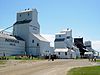 More images | |
| Ukrainian Greek Orthodox Church of the Ascension | Silver Creek MB | 50°44′06″N 101°01′01″W / 50.7349°N 101.017°W / 50.7349; -101.017 (Ukrainian Greek Orthodox Church of the Ascension) | Silver Creek municipality (9026) |  Upload Photo | |
| Lakedale Holy Ghost Ukrainian Catholic Church | Silver Creek MB | 50°47′01″N 100°58′26″W / 50.7835°N 100.974°W / 50.7835; -100.974 (Lakedale Holy Ghost Ukrainian Catholic Church) | Silver Creek municipality (14523) | Upload Photo | |
| Ukrainian People's Home of Ivan Franko | Wright Avenue Silver Creek MB | 50°44′03″N 101°01′05″W / 50.7343°N 101.018°W / 50.7343; -101.018 (Ukrainian People's Home of Ivan Franko) | Silver Creek municipality (2910) | Upload Photo | |
| Angusville Municipal Building | 235 Main Street Silver Creek MB | 50°44′03″N 101°01′12″W / 50.7343°N 101.02°W / 50.7343; -101.02 (Angusville Municipal Building) | Silver Creek municipality (8235) | Upload Photo | |
| North American Lumber Co. Building | 162 - 2nd Street Binscarth MB | 50°37′33″N 101°17′13″W / 50.6259°N 101.287°W / 50.6259; -101.287 (North American Lumber Co. Building) | Binscarth municipality (3218) | Upload Photo | |
| Bank of Montreal Building | 5 Railway Avenue North Ethelbert MB | 51°32′N 100°24′W / 51.53°N 100.4°W / 51.53; -100.4 (Bank of Montreal Building) | Ethelbert municipality (4174) | Upload Photo | |
| Ruskin School | Ethelbert MB | 51°30′49″N 100°26′20″W / 51.5136°N 100.439°W / 51.5136; -100.439 (Ruskin School) | Ethelbert municipality (8230) | Upload Photo | |
| Makaroff Hall | Shell River MB | 51°21′03″N 101°30′29″W / 51.3509°N 101.508°W / 51.3509; -101.508 (Makaroff Hall) | Shell River municipality (8455) | Upload Photo | |
| Ukrainian Greek Orthodox Church of St. John the Baptist | Ethelbert MB | 51°39′16″N 100°27′36″W / 51.6545°N 100.46°W / 51.6545; -100.46 (Ukrainian Greek Orthodox Church of St. John the Baptist) | Ethelbert municipality (8864) | Upload Photo | |
| Garland United Church | Ethelbert MB | 51°39′09″N 100°27′36″W / 51.6525°N 100.46°W / 51.6525; -100.46 (Garland United Church) | Ethelbert municipality (8865) | Upload Photo | |
| Toutes Aides Roman Catholic Church | Lawrence MB | 51°29′13″N 99°32′00″W / 51.487°N 99.5333°W / 51.487; -99.5333 (Toutes Aides Roman Catholic Church) | Lawrence municipality (6262) |  | |
| Ruthenian Greek Catholic Church of the Blessed Virgin Mary | Lawrence MB | 51°27′17″N 99°31′38″W / 51.4547°N 99.5271°W / 51.4547; -99.5271 (Ruthenian Greek Catholic Church of the Blessed Virgin Mary) | Lawrence municipality (6264) | Upload Photo | |
| St. Margaret's Anglican Church | 112 Willow Avenue Mountain (North) MB | 52°40′56″N 101°06′36″W / 52.6822°N 101.11°W / 52.6822; -101.11 (St. Margaret's Anglican Church) | Mountain (North) municipality (9025) | Upload Photo | |
| Griswold United Church | Patterson Street Sifton MB | 49°43′34″N 100°31′12″W / 49.7261°N 100.52°W / 49.7261; -100.52 (Griswold United Church) | Manitoba (4306) | Upload Photo | |
| Tummel United Church | Shell River MB | 51°08′24″N 101°23′53″W / 51.1401°N 101.398°W / 51.1401; -101.398 (Tummel United Church) | Shell River municipality (9441) | Upload Photo | |
| Horod School | NE 22-19-21W Park (South) MB | 50°39′07″N 100°18′00″W / 50.652°N 100.3°W / 50.652; -100.3 (Horod School) | Park (South) municipality (3749) | Upload Photo | |
| Sts. Peter and Paul Roman Catholic Church | SE 7-19-21 WPM Park (South) MB | 50°37′04″N 100°22′12″W / 50.6178°N 100.37°W / 50.6178; -100.37 (Sts. Peter and Paul Roman Catholic Church) | Park (South) municipality (4828) | Upload Photo | |
| Assumption of the Blessed Virgin Mary Ukrainian Catholic Church | Park (South) MB | 50°42′41″N 100°26′20″W / 50.7114°N 100.439°W / 50.7114; -100.439 (Assumption of the Blessed Virgin Mary Ukrainian Catholic Church) | Park (South) municipality (6256) | Upload Photo | |
| Ruthenian Greek Catholic Church of the Ascension | Park (South) MB | 50°38′19″N 100°10′16″W / 50.6387°N 100.171°W / 50.6387; -100.171 (Ruthenian Greek Catholic Church of the Ascension) | Park (South) municipality (6291) | Upload Photo | |
| Sts. Peter and Paul Ukrainian Orthodox Church | Park (South) MB | 50°40′57″N 100°29′06″W / 50.6826°N 100.485°W / 50.6826; -100.485 (Sts. Peter and Paul Ukrainian Orthodox Church) | Park (South) municipality (16347) | Upload Photo | |
| Sts. Peter and Paul Ukrainian United Church | Shellmouth-Boulton MB | 51°00′27″N 101°12′50″W / 51.0075°N 101.214°W / 51.0075; -101.214 (Sts. Peter and Paul Ukrainian United Church) | Shellmouth-Boulton municipality (6533) | Upload Photo | |
| St. Elijah Romanian Orthodox Church | SW 24-23-24 W Shellmouth-Boulton MB | 50°59′36″N 101°16′08″W / 50.9932°N 101.269°W / 50.9932; -101.269 (St. Elijah Romanian Orthodox Church) | Manitoba (3907) | Upload Photo | |
| Shellmouth United Church | Shellmouth-Boulton MB | 50°56′00″N 101°28′41″W / 50.9334°N 101.478°W / 50.9334; -101.478 (Shellmouth United Church) | Shellmouth-Boulton municipality (5371) | Upload Photo | |
| Paulencu House | Shellmouth-Boulton MB | 50°59′36″N 101°16′12″W / 50.9932°N 101.27°W / 50.9932; -101.27 (Paulencu House) | Manitoba (6435) | Upload Photo | |
| Our Lady of Seven Sorrows Roman Catholic Church | Mountain (South) MB | 52°00′15″N 100°09′04″W / 52.0041°N 100.151°W / 52.0041; -100.151 (Our Lady of Seven Sorrows Roman Catholic Church) | Manitoba (6266) | Upload Photo | |
| St. Michael's Ukrainian Catholic Church | NW 20-26-20 WPM Dauphin MB | 51°16′12″N 100°14′56″W / 51.2701°N 100.249°W / 51.2701; -100.249 (St. Michael's Ukrainian Catholic Church) | Manitoba (4107) | Upload Photo | |
| Elaschuk House | Roblin MB | 51°13′45″N 101°15′07″W / 51.2292°N 101.252°W / 51.2292; -101.252 (Elaschuk House) | Manitoba (4172) | Upload Photo | |
| Former Canadian Northern Railway Station | 126 First Avenue Roblin MB | 51°13′47″N 101°21′11″W / 51.2297°N 101.353°W / 51.2297; -101.353 (Former Canadian Northern Railway Station (Roblin)) | Federal (6547) | Upload Photo | |
| South Bay School | Winnipegosis MB | 51°40′59″N 100°03′04″W / 51.6831°N 100.051°W / 51.6831; -100.051 (South Bay School) | Winnipegosis municipality (6170) | Upload Photo | |
| Holy Resurrection Russian Orthodox Church | Ogryzlo Street Dauphin MB | 51°21′37″N 100°08′20″W / 51.3602°N 100.139°W / 51.3602; -100.139 (Holy Resurrection Russian Orthodox Church) | Dauphin municipality (6259) | Upload Photo | |
| Tamarisk United Church | Grandview MB | 50°11′46″N 100°38′53″W / 50.1961°N 100.648°W / 50.1961; -100.648 (Tamarisk United Church) | Manitoba (5097) | Upload Photo | |
| Tamarisk School | Grandview MB | 51°05′46″N 100°40′12″W / 51.0962°N 100.67°W / 51.0962; -100.67 (Tamarisk School) | Manitoba (15281), Grandview municipality (6159) | Upload Photo | |
| Rhodes Community Hall | Dauphin MB | 51°28′31″N 100°31′59″W / 51.4753°N 100.533°W / 51.4753; -100.533 (Rhodes Community Hall) | Dauphin municipality (8456) | Upload Photo | |
| Cromarty School | Roblin MB | 51°13′40″N 101°28′08″W / 51.2278°N 101.469°W / 51.2278; -101.469 (Cromarty School) | Roblin municipality (8457) | Upload Photo | |
| Ukrainian Greek Orthodox Church of Sts. Peter and Paul | Dauphin MB | 51°00′48″N 100°12′11″W / 51.0133°N 100.203°W / 51.0133; -100.203 (Ukrainian Greek Orthodox Church of Sts. Peter and Paul) | Dauphin municipality (9422) | Upload Photo | |
| T.A. Burrows Mill Site | Grandview MB | 51°10′47″N 100°42′47″W / 51.1797°N 100.713°W / 51.1797; -100.713 (T.A. Burrows Mill Site) | Grandview municipality (11501) | Upload Photo | |
| Dauphin Town Hall | 104 1st Avenue NW Dauphin MB | 51°09′03″N 100°03′04″W / 51.1508°N 100.051°W / 51.1508; -100.051 (Dauphin Town Hall) | Manitoba (3974) |  | |
| Former Canadian Northern Railway Station | 101 1st Avenue NW Dauphin MB | 51°09′00″N 100°03′04″W / 51.15°N 100.051°W / 51.15; -100.051 (Former Canadian Northern Railway Station (Dauphin)) | Federal (6496), Manitoba (3921) |  More images | |
| Ukrainian Catholic Church of the Resurrection National Historic Site of Canada | 1106 First Street SW Dauphin MB | 51°08′31″N 100°03′43″W / 51.1419°N 100.062°W / 51.1419; -100.062 (Ukrainian Catholic Church of the Resurrection National Historic Site of Canada) | Federal (12283), Manitoba (3917) |  | |
| Negrych Homestead | SE 14-27-22 W Gilbert Plains MB | 51°18′24″N 100°27′07″W / 51.3066°N 100.452°W / 51.3066; -100.452 (Negrych Homestead) | Manitoba (3912) | Upload Photo | |
| Gilbert Plains Beef Ring Building | Gilbert Plains MB | 51°05′36″N 100°27′47″W / 51.0932°N 100.463°W / 51.0932; -100.463 (Gilbert Plains Beef Ring Building) | Gilbert Plains municipality (8388) | Upload Photo | |
| Law Office Building | 510 Main Street Swan River MB | 52°06′20″N 101°16′12″W / 52.1056°N 101.27°W / 52.1056; -101.27 (Law Office Building) | Swan River municipality (8395) | Upload Photo | |
| Satterthwaite House | McCreary MB | 50°42′34″N 99°29′10″W / 50.7094°N 99.4862°W / 50.7094; -99.4862 (Satterthwaite House) | McCreary municipality (5082) | Upload Photo | |
| Canal School | Railway Street McCreary MB | 50°46′27″N 99°29′33″W / 50.7741°N 99.4925°W / 50.7741; -99.4925 (Canal School) | McCreary municipality (5798) | Upload Photo | |
| Former Canadian Northern Railway Station | Railway St. (between 1st and 2nd Ave.) McCreary MB | 50°46′24″N 99°29′25″W / 50.7734°N 99.4902°W / 50.7734; -99.4902 (Former Canadian Northern Railway Station (McCreary)) | Federal (6630) | Upload Photo | |
| Torsky Cabin | Rossburn MB | 50°44′42″N 100°48′25″W / 50.7449°N 100.807°W / 50.7449; -100.807 (Torsky Cabin) | Rossburn municipality (6158) | Upload Photo | |
| Armstrong Farm Site | Rossburn MB | 50°35′57″N 100°47′20″W / 50.5993°N 100.789°W / 50.5993; -100.789 (Armstrong Farm Site) | Rossburn municipality (6257) | Upload Photo | |
| Ukrainian Pioneer Mass Grave Site | Rossburn MB | 50°38′28″N 100°35′38″W / 50.6412°N 100.594°W / 50.6412; -100.594 (Ukrainian Pioneer Mass Grave Site) | Rossburn municipality (6258) | Upload Photo | |
| Sts. Peter and Paul Ukrainian Catholic Church | Rossburn MB | 50°41′57″N 100°40′34″W / 50.6992°N 100.676°W / 50.6992; -100.676 (Sts. Peter and Paul Ukrainian Catholic Church) | Rossburn municipality (6263) | Upload Photo | |
| Our Lady of the Assumption Roman Catholic Church | Rossburn MB | 50°38′20″N 100°33′14″W / 50.639°N 100.554°W / 50.639; -100.554 (Our Lady of the Assumption Roman Catholic Church) | Rossburn municipality (6290) | Upload Photo | |
| Ukrainian Greek Orthodox Church of the Assumption of St. Mary | Rossburn MB | 50°47′08″N 100°51′25″W / 50.7855°N 100.857°W / 50.7855; -100.857 (Ukrainian Greek Orthodox Church of the Assumption of St. Mary) | Rossburn municipality (6491) | Upload Photo | |
| Marconi School | NW 23-20-23 WPM Rossburn MB | 50°44′24″N 100°34′34″W / 50.74°N 100.576°W / 50.74; -100.576 (Marconi School) | Rossburn municipality (3750) | Upload Photo | |
| St. Michael's Ukrainian Catholic Church | Rossburn MB | 50°40′10″N 100°33′18″W / 50.6694°N 100.555°W / 50.6694; -100.555 (St. Michael's Ukrainian Catholic Church) | Rossburn municipality (6673) | Upload Photo | |
| Glen Elmo School | Rossburn MB | 50°50′39″N 100°50′02″W / 50.8443°N 100.834°W / 50.8443; -100.834 (Glen Elmo School) | Rossburn municipality (6916) | Upload Photo | |
| Smellie Bros. and Co. Store | 300 Main Street Russell MB | 50°14′49″N 99°50′36″W / 50.2469°N 99.8433°W / 50.2469; -99.8433 (Smellie Bros. and Co. Store) | Russell municipality (2715) | Upload Photo | |
| Harley House | 515 2nd Street North Swan River MB | 52°06′20″N 101°15′54″W / 52.1056°N 101.265°W / 52.1056; -101.265 (Harley House) | Swan River municipality (16348) | Upload Photo | |
| Superintendent's Residence and Works Garage | Riding Mountain National Park Wasagaming MB | 50°40′33″N 99°54′51″W / 50.6757°N 99.9141°W / 50.6757; -99.9141 (Superintendent's Residence and Works Garage) | Federal (3457, (3456) |  More images | |
| Staff Residence Building B-15 | 150 Ta-wa-pit Drive, Riding Mountain National Park Wasagaming MB | 50°41′10″N 99°58′05″W / 50.686°N 99.968°W / 50.686; -99.968 (Staff Residence Building B-15) | Federal (3459) |  More images | |
| Warden's Station Residence No. 1, Building B-18 | Riding Mountain National Park Wasagaming MB | 50°53′00″N 100°15′00″W / 50.8833°N 100.25°W / 50.8833; -100.25 (Warden's Station Residence No. 1, Building B-18) | Federal (4271) | Upload Photo | |
| Bandstand (B9) | Riding Mountain National Park Wasagaming MB | 50°53′00″N 100°15′00″W / 50.8833°N 100.25°W / 50.8833; -100.25 (Bandstand (B9)) | Federal (4278) | 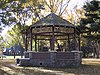 More images | |
| Accountant's Residence | 154 Columbine Street Wasagaming MB | 50°53′00″N 100°15′00″W / 50.8833°N 100.25°W / 50.8833; -100.25 (Accountant's Residence) | Federal (4276) | 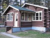 More images | |
| Casa Loma, Building (A2) | 154 Wasagaming Drive Wasagaming MB | 50°53′00″N 100°15′00″W / 50.8833°N 100.25°W / 50.8833; -100.25 (Casa Loma, Building (A2)) | Federal (4280) |  More images | |
| Jamboree Hall, Building B-10 | Wasagaming MB | 50°53′00″N 100°15′00″W / 50.8833°N 100.25°W / 50.8833; -100.25 (Jamboree Hall, Building B-10) | Federal (4282) | Upload Photo | |
| Tennis Clubhouse (B-6) | Riding Mountain National Park Wasagaming MB | 50°53′00″N 100°15′00″W / 50.8833°N 100.25°W / 50.8833; -100.25 (Tennis Clubhouse (B-6)) | Federal (4284) | 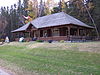 More images | |
| Riding Mountain Park East Gate Registration Complex National Historic Site of Canada | Norgate Road, Riding Mountain National Park Wasagaming MB | 50°41′00″N 99°33′19″W / 50.6833°N 99.5554°W / 50.6833; -99.5554 (Riding Mountain Park East Gate Registration Complex National Historic Site of Canada) | Federal (10550, (9479) | 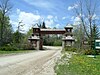 | |
| Fire Hall (B-3) | 126 Tawapit Drive, Riding Mountain National Park Wasagaming MB | 50°53′00″N 100°15′00″W / 50.8833°N 100.25°W / 50.8833; -100.25 (Fire Hall (B-3)) | Federal (9480) |  More images | |
| Doctor’s Residence and Clinic (C5) | 140 Ta-wa-pit Drive Wasagaming MB | 50°53′00″N 100°15′00″W / 50.8833°N 100.25°W / 50.8833; -100.25 (Doctor’s Residence and Clinic (C5)) | Federal (9483) |  More images | |
| Golf Clubhouse (B7) | Riding Mountain National Park Wasagaming MB | 50°53′00″N 100°15′00″W / 50.8833°N 100.25°W / 50.8833; -100.25 (Golf Clubhouse (B7)) | Federal (9783) | Upload Photo | |
| Grey Owl's Cabin (B21) | Wasagaming MB | 50°41′10″N 99°58′05″W / 50.686°N 99.968°W / 50.686; -99.968 (Grey Owl's Cabin (B21)) | Federal (9915) | Upload Photo | |
| Royal Canadian Air Force Cottage (B16) | Wasagaming MB | 50°53′00″N 100°15′00″W / 50.8833°N 100.25°W / 50.8833; -100.25 (Royal Canadian Air Force Cottage (B16)) | Federal (9917) | Upload Photo | |
| Whirlpool Wardens' Residence | Riding Mountain Park East Gate Registration Complex National Historic Site of Canada Wasagaming MB | 50°41′00″N 99°33′22″W / 50.6832°N 99.5562°W / 50.6832; -99.5562 (Whirlpool Wardens' Residence) | Federal (9918, (11181) | Upload Photo | |
| Interpretive Centre B1 | Riding Mountain National Park Wasagaming MB | 50°53′00″N 100°15′00″W / 50.8833°N 100.25°W / 50.8833; -100.25 (Interpretive Centre B1) | Federal (14829) |  | |
| Park Administration Building | Riding Mountain National Park Wasagaming MB | 50°59′06″N 100°03′47″W / 50.9851°N 100.063°W / 50.9851; -100.063 (Park Administration Building) | Federal (2888) | 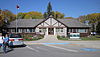 More images |
See also
- v
- t
- e
- Asessippi
- Atikaki
- Bakers Narrows
- Beaudry
- Beaver Creek
- Bell Lake
- Birch Island
- Birch Point
- Birds Hill
- Burge Lake
- Camp Morton
- Caribou River
- Chitek Lake Anishinaabe
- Clearwater Lake
- Colvin Lake
- Criddle/Vane Homestead
- Duck Mountain
- Duff Roblin
- Elk Island
- Fisher Bay
- Grand Beach
- Grand Rapids
- Grand Valley
- Grass River
- Hecla-Grindstone
- Hnausa Beach
- Hyland
- Kettle Stones
- Kinwow Bay
- Lake St. Andrew
- Lake St. George
- Little Limestone Lake
- Lockport
- Lundar Beach
- Manigotagan River
- Manipogo
- Marchland
- Margaret Bruce
- Memorial
- Moose Lake
- Neso Lake
- Netley Creek
- Nopiming
- Norris Lake
- North Steeprock Lake
- Nueltin Lake
- Numaykoos Lake
- Oak Lake
- Overflowing River
- Paint Lake
- Patricia Beach
- Pembina Valley
- Pinawa Dam
- Pinawa
- Pisew Falls
- Poplar Bay
- Portage Spillway
- Primrose
- Rainbow Beach
- Red Deer River
- River Road
- Rivers
- Rocky Lake
- Sand Lakes
- Sasagiu Rapids
- Seton
- South Atikaki
- Springwater
- Spruce Woods
- St. Ambroise Beach
- St. Malo
- St. Norbert
- Stephenfield
- Sturgeon Bay
- Swan River
- Trappest Monastery
- Turtle Mountain
- Twin Lakes
- Upper Fort Garry Heritage
- Wallace Lake
- Watchorn
- Wekusko Falls
- Whitefish Lake
- Whitemouth Falls
- Whiteshell
- William Lake
- Winnipeg Beach
- Woodridge
- Yellow Quill
- Zed Lake
- Agassiz
- Belair
- Brightstone Sand Hill
- Cat Hills
- Cormorant
- Duck Mountain
- Moose Creek
- Northwest Angle
- Porcupine
- Sandilands
- Spruce Woods
- Swan-Pelican
- Turtle Mountain
- Wampum
- Whiteshell
- Armit Meadows
- Baralzon Lake
- Birch River
- Brokenhead River
- Brokenhead Wetland
- Cedar Bog
- Cowan Bog
- Holmgren Pines
- Jennifer and Tom Shay
- Kaweenakumik Islands
- Lake St. George Caves
- Lake Winnipegosis Salt Flats
- Lewis Bog
- Libau Bog
- Little George Island
- Long Point
- Palsa Hazel
- Pelican Islands
- Piney
- Pocock Lake
- Red Rock
- Reindeer Island
- Ste. Anne Bog
- St. Labre Bog
- Walter Cook Caves
- Wampum
- Whitemouth Bog
- Whitemouth Island
- Whitemouth River
- Woodridge
- Alonsa
- Assiniboine Corridor
- Basket Lake
- Bernice
- Brandon Hills
- Broad Valley
- Broomhill
- C. Stewart Stevenson
- Catfish Creek
- Cayer
- Churchill
- Delta Marsh
- Deerwood
- Dog Lake
- Ebor
- Gerald W. Malaher
- Grant's Lake
- Gypsumville
- Harrison
- Hilbre
- Holmfield
- Kasatamagan Sipi
- Kasatamagan
- Lake Francis
- Langruth
- Lauder Sandhills
- Lee Lake
- Lee River
- Little Birch
- Little Saskatchewan
- Manatagao
- Maple Lake
- Mars Hill
- Marshy Point
- Moose Creek
- Narcisse
- Oak Hammock Marsh
- Observation Point
- Oranole
- Otter Lake
- Parkland
- Pembina Valley
- Penonan Point
- Pierson
- Point River
- Portage Sandhills
- Proven Lake
- Proulx Lake
- Rat River
- Red Deer
- Riverside
- Saskeram
- Sleeve Lake
- Souris River Bend
- Spruce Woods
- Spur Woods
- St. Malo
- Steeprock
- Stuartburn
- Thalberg Bush
- Tiger Hills
- Tom Lamb
- Turtle Mountain
- Upper Assiniboine
- Wakopa
- Washow Bay
- Watson P. Davidson
- Weiden
- Wellington
- Westlake
- Whitemouth Bog
- Whitemud Watershed
- Whitewater Lake
World Biosphere Reserves
- Assiniboine
- Bruce
- Central
- Kil-Cona
- Kildonan
- King's
- Living Prairie Museum
- Maple Grove
- St. Vital
- Stephen Juba
 Category
- Conservation Districts
- Parks Canada
 Commons


