Madrean Sky Islands
Peak-isolated biomes in Arizona, New Mexico, and Mexico
- Mexico
- United States
- Arizona
- Chihuahua
- New Mexico
The Madrean Sky Islands are enclaves of Madrean pine–oak woodlands, found at higher elevations in a complex of small mountain ranges in southern and southeastern Arizona, southwestern New Mexico, and northwestern Mexico. The sky islands are surrounded at lower elevations by the Sonoran and Chihuahuan deserts. The northern west–east perimeter of the sky island region merges into the higher elevation eastern Mogollon Rim and the White Mountains of eastern Arizona (southern Anasazi region).
The sky islands are the northernmost of the Madrean pine–oak woodlands, and are classified as part of the Sierra Madre Occidental pine–oak forests ecoregion, of the tropical and subtropical coniferous forests biome. The sky islands were isolated from one another and from the pine–oak woodlands of the Sierra Madre Occidental to the south by the warming and drying of the climate since the ice ages.
There are approximately 27 Madrean sky islands in the United States, and 15 in northern Mexico. The major Madrean sky island ranges in Arizona are the Baboquivari Mountains, Chiricahua Mountains, Huachuca Mountains, Pinaleño Mountains, Santa Catalina Mountains, Santa Rita Mountains and Whetstone Mountains. Similar sky island ranges include the Animas Mountains in New Mexico and the Guadalupe Mountains, Davis Mountains and Chisos Mountains in west Texas.
Significant urban areas located very close to the Madrean Sky Islands include Las Cruces, New Mexico, and Tucson, Arizona.
Fauna
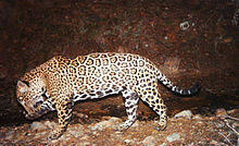
Though formerly extirpated from the United States, the North American jaguar has returned to the area from northern Mexico in small numbers. One such jaguar is named El Jefe.[1]
See also
- Madrean Region
- List of birds of the Madrean Sky Islands
- List of Madrean Sky Island mountain ranges – Sonoran – Chihuahuan Deserts
- Malpai Borderlands
References
- ^ Richard Grant (October 2016). "The Return of the Great American Jaguar". Smithsonian. Retrieved 2016-10-02.
External links
- Sky Island Alliance homepage
- U.S. Geologic Survey: Biology of the Southwestern Sky Island Ecosystems
- Bioimages.vanderbilt.edu: Madrean Sky Islands Montane Forests images; (slow modem version)
- "Sierra Madre Occidental pine-oak woodlands". Terrestrial Ecoregions. World Wildlife Fund.
- v
- t
- e
Level III Ecoregions in the United States
- 1 Coast Range
- 2 Puget Lowland
- 3 Willamette Valley
- 111 Ahklun and Kilbuck Mountains
- 113 Alaska Peninsula Mountains
- 115 Cook Inlet
- 119 Pacific Coastal Mountains
- 120 Coastal Western Hemlock-Sitka Spruce Forests
- 4 Cascades
- 5 Sierra Nevada
- 9 Eastern Cascades Slopes and Foothills
- 11 Blue Mountains
- 15 Northern Rockies
- 16 Idaho Batholith
- 17 Middle Rockies
- 19 Wasatch and Uinta Mountains
- 21 Southern Rockies
- 41 Canadian Rockies
- 77 North Cascades
- 78 Klamath Mountains
- 105 Interior Highlands
- 116 Alaska Range
- 117 Copper Plateau
- 118 Wrangell Mountains
- 6 Southern and Central California Chaparral and Oak Woodlands
- 7 Central California Valley
- 8 Southern California Mountains
- 10 Columbia Plateau
- 12 Snake River Plain
- 13 Central Basin and Range
- 14 Mojave Basin and Range
- 18 Wyoming Basin
- 20 Colorado Plateaus
- 22 Arizona/New Mexico Plateau
- 24 Chihuahuan Deserts
- 80 Northern Basin and Range
- 81 Sonoran Basin and Range
- 23 Arizona/New Mexico Mountains
- 25 Western High Plains
- 26 Southwestern Tablelands
- 27 Central Great Plains
- 28 Flint Hills
- 29 Central Oklahoma/Texas Plains (Cross Timbers)
- 30 Edwards Plateau
- 31 Southern Texas Plains
- 34 Western Gulf Coastal Plain
- 40 Central Irregular Plains
- 42 Northwestern Glaciated Plains
- 43 Northwestern Great Plains
- 44 Nebraska Sand Hills
- 45 Piedmont
- 46 Northern Glaciated Plains
- 47 Western Corn Belt Plains
- 48 Lake Agassiz Plain
- 32 Texas Blackland Prairies
- 33 East Central Texas Plains
- 35 South Central Plains
- 36 Ouachita Mountains
- 37 Arkansas Valley
- 38 Boston Mountains
- 39 Ozark Highlands
- 51 North Central Hardwood Forests
- 52 Driftless Area
- 53 Southeastern Wisconsin Till Plains
- 54 Central Corn Belt Plains
- 55 Eastern Corn Belt Plains
- 56 Southern Michigan/Northern Indiana Drift Plains
- 57 Huron/Erie Lake Plains
- 59 Northeastern Coastal Zone
- 60 Northern Appalachian Plateau and Uplands
- 61 Erie Drift Plain
- 63 Middle Atlantic Coastal Plain
- 64 Northern Piedmont
- 65 Southeastern Plains
- 66 Blue Ridge
- 67 Ridge and Valley
- 68 Southwestern Appalachians
- 69 Central Appalachians
- 70 Western Allegheny Plateau
- 71 Interior Plateau
- 72 Interior River Valleys and Hills
- 73 Mississippi Alluvial Plain
- 74 Mississippi Valley Loess Plains
- 75 Southern Coastal Plain
- 82 Laurentian Plains and Hills
- 83 Eastern Great Lakes and Hudson Lowlands
- 84 Atlantic Coastal Pine Barrens
- 49 Northern Minnesota Wetlands
- 50 Northern Lakes and Forests
- 58 Northeastern Highlands
- 62 North Central Appalachians
- 76 Southern Florida Coastal Plain
- 79 Madrean Archipelago
- 101 Arctic Coastal Plain
- 102 Arctic Foothills
- 103 Brooks Range
- 104 Interior Forested Lowlands and Uplands
- 106 Interior Bottomlands
- 107 Yukon Flats
- 108 Ogilvie Mountains
- 109 Subarctic Coastal Plains
- 110 Seward Peninsula
- 112 Bristol Bay-Nushagak Lowlands
- 114 Aleutian Islands
as defined by the United States Environmental Protection Agency[1]
Authority control databases | |
|---|---|
| International |
|
| National |
|


