Manassas Gap
| Manassas Gap | |
|---|---|
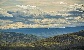 Manassas Gap taken from Apple Mountain Lake (Linden, VA) | |
| Elevation | 887 ft (270 m) |
| Traversed by |  Interstate 66 Interstate 66  Virginia State Highway 55 Virginia State Highway 55 |
| Location | Fauquier / Warren counties, Virginia, United States |
| Range | Blue Ridge Mountains |
| Coordinates | 38°54′32″N 78°04′32″W / 38.90889°N 78.07556°W / 38.90889; -78.07556 |
Manassas Gap is a wind gap of the Blue Ridge Mountains on the border of Fauquier County and Warren County in Virginia. At an elevation of 887 feet above sea level, it is the lowest crossing of the Blue Ridge Mountains in the state. "The origins of the name "Manassas" are undocumented."[1]
The Manassas Gap Railroad was completed through this pass in 1854, and today, the tracks form a part of the Norfolk Southern rail system. Virginia State Route 55 and Interstate 66 also pass through Manassas Gap. In addition the north-south Appalachian Trail crosses the gap as well.
Virginia's independent cities of Manassas and Manassas Park derived their names from the railroad which was built through Manassas Gap.
References
- ^ "Manassas". Virginia Places. Retrieved Aug 5, 2022.
External links
- Virginia Places web site a large site with much educational information about the Geography of Virginia
- v
- t
- e
Gaps of the Appalachian Mountains
- Appalachian Gap
- Balsam Gap
- Brock Gap
- Buck Creek Gap
- Bull Gap
- Carter Notch
- Cowee Gap
- Craven Gap
- Crawford Notch
- Deals Gap
- Dixville Notch
- Evans Notch
- Franconia Notch
- Gillespie Gap
- Grafton Notch
- Grandmother Gap
- Granville Notch
- Hazen's Notch
- Hobart Gap
- Kinsman Notch
- Lincoln Gap
- Mahoosuc Notch
- Middlebury Gap
- Monterey Pass
- Newfound Gap
- Pinkham Notch
- Sherburne Pass
- Skinners Gap
- Smugglers Notch
- Soco Gap
- Stony Clove Notch
- Zealand Notch
 | This Fauquier County, Virginia state location article is a stub. You can help Wikipedia by expanding it. |
- v
- t
- e
 | This Warren County, Virginia state location article is a stub. You can help Wikipedia by expanding it. |
- v
- t
- e


