Mount Gilead, Tennessee
Unincorporated community in Tennessee, United States
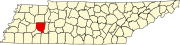
35°45′57″N 88°32′23″W / 35.76583°N 88.53972°W / 35.76583; -88.53972Mount Gilead, Tennessee (sometimes called Mt. Gilead) is an unincorporated community located in Henderson County, Tennessee, United States at latitude 35.766 and longitude -88.54, at an elevation of 561 feet.[1] It is on O'Brien Road west of Tennessee Highway 104, approximately 8 kilometres south-southeast of Cedar Grove, Tennessee.[2] As late as 1926, Mount Gilead had its own school.[3]
References
- v
- t
- e
Municipalities and communities of Henderson County, Tennessee, United States
County seat: Lexington
- Lexington
- Parkers Crossroads
communities
- Cedar Grove
- Crucifer
- Independence
- Juno
- Life
- Middle Fork
- Mount Gilead
- Reagan
‡This populated place also has portions in an adjacent county or counties
- Tennessee portal
- United States portal
 | This Henderson County, Tennessee geography–related article is a stub. You can help Wikipedia by expanding it. |
- v
- t
- e


