National Register of Historic Places listings in Adams County, Idaho

This is a list of the National Register of Historic Places listings in Adams County, Idaho.
This is intended to be a complete list of the properties and districts on the National Register of Historic Places in Adams County, Idaho, United States. Latitude and longitude coordinates are provided for many National Register properties and districts; these locations may be seen together in a map.[1]
There are 8 properties and districts listed on the National Register in the county. More may be added; properties and districts nationwide are added to the Register weekly.[2]
This National Park Service list is complete through NPS recent listings posted June 14, 2024.[3]
Map all coordinates using OpenStreetMap
Download coordinates as:
- KML
- GPX (all coordinates)
- GPX (primary coordinates)
- GPX (secondary coordinates)
Current listings
| [4] | Name on the Register[5] | Image | Date listed[6] | Location | City or town | Description |
|---|---|---|---|---|---|---|
| 1 | Adams County Courthouse |  | September 22, 1987 (#87001599) | Michigan St. 44°43′39″N 116°26′18″W / 44.727557°N 116.438307°W / 44.727557; -116.438307 (Adams County Courthouse) | Council | |
| 2 | Council Ranger Station | 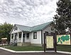 | November 19, 1992 (#92000689) | Junction of U.S. Route 95 and Whiteley Ave. 44°43′50″N 116°25′56″W / 44.730618°N 116.432239°W / 44.730618; -116.432239 (Council Ranger Station) | Council | |
| 3 | Col. E. M. Heigho House |  | May 22, 1978 (#78001041) | State Highway 55 44°58′21″N 116°16′48″W / 44.9725°N 116.28°W / 44.9725; -116.28 (Col. E. M. Heigho House) | New Meadows | |
| 4 | Hells Canyon Archeological District | Upload image | August 10, 1984 (#84000984) | Address Restricted | Cuprum | Extends into Idaho and Nez Perce counties and Wallowa County, Oregon |
| 5 | A. O. Huntley Barn | Upload image | November 14, 1978 (#78001040) | West of Cuprum 45°04′11″N 116°43′09″W / 45.069722°N 116.719167°W / 45.069722; -116.719167 (A. O. Huntley Barn) | Cuprum | |
| 6 | Indian Mountain Fire Lookout | Upload image | August 11, 2022 (#100007977) | National Forest Road 243, 12 miles SE of Council, Idaho, Payette National Forest 44°35′55″N 116°14′57″W / 44.5986°N 116.2491°W / 44.5986; -116.2491 (Indian Mountain Fire Lookout) | Council vicinity | |
| 7 | Meadows Schoolhouse |  | October 30, 1979 (#79000769) | State Highway 55 44°57′40″N 116°14′44″W / 44.961111°N 116.245556°W / 44.961111; -116.245556 (Meadows Schoolhouse) | New Meadows | |
| 8 | Pacific and Idaho Northern Railroad Depot |  | April 19, 1978 (#78001042) | U.S. Route 95 44°58′14″N 116°17′16″W / 44.970538°N 116.2878357°W / 44.970538; -116.2878357 (Pacific and Idaho Northern Railroad Depot) | New Meadows |
Former listings
| [4] | Name on the Register | Image | Date listed | Date removed | Location | City or town | Description |
|---|---|---|---|---|---|---|---|
| 1 | Pomona Hotel | Upload image | May 22, 1978 (#78001039) | January 31, 1986 | Main and Moser Sts. | Council | Destroyed by fire in April, 1985 |
See also
Wikimedia Commons has media related to National Register of Historic Places in Adams County, Idaho.
 Idaho portal
- List of National Historic Landmarks in Idaho
- National Register of Historic Places listings in Idaho
References
- ^ The latitude and longitude information provided in this table was derived originally from the National Register Information System, which has been found to be fairly accurate for about 99% of listings. Some locations in this table may have been corrected to current GPS standards.
- ^ "National Register of Historic Places: Weekly List Actions". National Park Service. Retrieved March 29, 2009.
- ^ National Park Service, United States Department of the Interior, "National Register of Historic Places: Weekly List Actions", retrieved June 14, 2024.
- ^ a b Numbers represent an alphabetical ordering by significant words. Various colorings, defined here, differentiate National Historic Landmarks and historic districts from other NRHP buildings, structures, sites or objects.
- ^ "National Register Information System". National Register of Historic Places. National Park Service. April 24, 2008.
- ^ The eight-digit number below each date is the number assigned to each location in the National Register Information System database, which can be viewed by clicking the number.
- v
- t
- e
- Ada
- Adams
- Bannock
- Bear Lake
- Benewah
- Bingham
- Blaine
- Boise
- Bonner
- Bonneville
- Boundary
- Butte
- Camas
- Canyon
- Caribou
- Cassia
- Clark
- Clearwater
- Custer
- Elmore
- Franklin
- Fremont
- Gem
- Gooding
- Idaho
- Jefferson
- Jerome
- Kootenai
- Latah
- Lemhi
- Lewis
- Lincoln
- Madison
- Minidoka
- Nez Perce
- Oneida
- Owyhee
- Payette
- Power
- Shoshone
- Teton
- Twin Falls
- Valley
- Washington

| |
|---|---|
| Topics | |
| Lists by state |
|
| Lists by insular areas | |
| Lists by associated state | |
| Other areas | |
| Related | |
| |


Municipalities and communities of Adams County, Idaho, United States | ||
|---|---|---|
County seat: Council | ||
| Cities |  | |
| Unincorporated communities | ||
| ||
State of Idaho | |
|---|---|
Boise (capital) | |
| Topics |
|
| Society | |
| Regions | |
| Larger cities | |
| Smaller cities | |
| Counties |
|
 Idaho portal Idaho portal | |


