National Register of Historic Places listings in Cloud County, Kansas

This is a list of the National Register of Historic Places listings in Cloud County, Kansas.
This is intended to be a complete list of the properties and districts on the National Register of Historic Places in Cloud County, Kansas, United States. The locations of National Register properties and districts for which the latitude and longitude coordinates are included below, may be seen in a map.[1]
There are 10 properties and districts listed on the National Register in the county.
This National Park Service list is complete through NPS recent listings posted June 14, 2024.[2]
Map all coordinates using OpenStreetMap
Download coordinates as:
- KML
- GPX (all coordinates)
- GPX (primary coordinates)
- GPX (secondary coordinates)
Current listings
| [3] | Name on the Register[4] | Image | Date listed[5] | Location | City or town | Description |
|---|---|---|---|---|---|---|
| 1 | Bankers Loan and Trust Company Building |  | November 9, 1977 (#77000576) | 101 E. 6th and 517 Broadway 39°34′18″N 97°39′31″W / 39.571667°N 97.658611°W / 39.571667; -97.658611 (Bankers Loan and Trust Company Building) | Concordia | |
| 2 | Brown Grand Opera House | 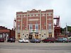 | July 26, 1973 (#73000747) | 310 W. 6th St. 39°34′17″N 97°39′46″W / 39.571389°N 97.662778°W / 39.571389; -97.662778 (Brown Grand Opera House) | Concordia | |
| 3 | Clyde School | Upload image | January 22, 2009 (#08001348) | 620 Broadway St. 39°35′25″N 97°24′11″W / 39.590244°N 97.403022°W / 39.590244; -97.403022 (Clyde School) | Clyde | |
| 4 | County Line Bowstring |  | January 4, 1990 (#89002192) | Over West Creek, northwest of Hollis 39°39′12″N 97°34′21″W / 39.653333°N 97.5725°W / 39.653333; -97.5725 (County Line Bowstring) | Hollis | |
| 5 | Glasco Downtown Historic District |  | November 17, 2002 (#02001307) | Roughly along Main St. from Railroad Ave. to Fisher St., and along Railroad Ave. and Fisher St. between Main and Buffalo Sts. 39°21′40″N 97°50′23″W / 39.361111°N 97.839722°W / 39.361111; -97.839722 (Glasco Downtown Historic District) | Glasco | |
| 6 | Nazareth Convent and Academy | 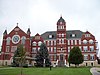 | January 18, 1973 (#73000748) | 13th and Washington Sts. 39°33′49″N 97°39′38″W / 39.563611°N 97.660556°W / 39.563611; -97.660556 (Nazareth Convent and Academy) | Concordia | |
| 7 | Pott's Ford Bridge |  | January 4, 1990 (#89002173) | Over Solomon River, southeast of Glasco 39°21′01″N 97°51′15″W / 39.350278°N 97.854167°W / 39.350278; -97.854167 (Pott's Ford Bridge) | Glasco | |
| 8 | Republican River Pegram Truss |  | January 4, 1990 (#89002190) | Route 795 over the Republican River 39°35′46″N 97°34′16″W / 39.596111°N 97.571111°W / 39.596111; -97.571111 (Republican River Pegram Truss) | Concordia | |
| 9 | Union Pacific Railroad Depot |  | January 21, 2004 (#03001465) | 300 Washington St. 39°34′24″N 97°39′41″W / 39.573333°N 97.661389°W / 39.573333; -97.661389 (Union Pacific Railroad Depot) | Concordia | |
| 10 | Charles W. Van De Mark House |  | July 5, 1985 (#85001492) | 504 Washington 39°35′27″N 97°24′01″W / 39.590833°N 97.400278°W / 39.590833; -97.400278 (Charles W. Van De Mark House) | Clyde |
See also
Wikimedia Commons has media related to National Register of Historic Places in Cloud County, Kansas.
- List of National Historic Landmarks in Kansas
- National Register of Historic Places listings in Kansas
References
- ^ The latitude and longitude information provided in this table was derived originally from the National Register Information System, which has been found to be fairly accurate for about 99% of listings. Some locations in this table may have been corrected to current GPS standards.
- ^ National Park Service, United States Department of the Interior, "National Register of Historic Places: Weekly List Actions", retrieved June 14, 2024.
- ^ Numbers represent an alphabetical ordering by significant words. Various colorings, defined here, differentiate National Historic Landmarks and historic districts from other NRHP buildings, structures, sites or objects.
- ^ "National Register Information System". National Register of Historic Places. National Park Service. March 13, 2009.
- ^ The eight-digit number below each date is the number assigned to each location in the National Register Information System database, which can be viewed by clicking the number.
- v
- t
- e

- Allen
- Anderson
- Atchison
- Barber
- Barton
- Bourbon
- Brown
- Butler
- Chase
- Chautauqua
- Cherokee
- Cheyenne
- Clark
- Clay
- Cloud
- Coffey
- Comanche
- Cowley
- Crawford
- Decatur
- Dickinson
- Doniphan
- Douglas
- Edwards
- Elk
- Ellis
- Ellsworth
- Finney
- Ford
- Franklin
- Geary
- Gove
- Graham
- Grant
- Gray
- Greeley
- Greenwood
- Hamilton
- Harper
- Harvey
- Haskell
- Hodgeman
- Jackson
- Jefferson
- Jewell
- Johnson
- Kearny
- Kingman
- Kiowa
- Labette
- Lane
- Leavenworth
- Lincoln
- Linn
- Logan
- Lyon
- Marion
- McPherson
- Meade
- Miami
- Mitchell
- Montgomery
- Morris
- Morton
- Nemaha
- Neosho
- Ness
- Norton
- Osage
- Osborne
- Ottawa
- Pawnee
- Phillips
- Pottawatomie
- Pratt
- Rawlins
- Reno
- Republic
- Rice
- Riley
- Rooks
- Rush
- Russell
- Saline
- Scott
- Sedgwick
- Seward
- Shawnee
- Sheridan
- Sherman
- Smith
- Stafford
- Stanton
- Stevens
- Sumner
- Thomas
- Trego
- Wabaunsee
- Wallace
- Washington
- Wichita
- Wilson
- Woodson
- Wyandotte
- Archaeological sites
- National Historic Landmarks
 Category
 NRHP portal


Municipalities and communities of Cloud County, Kansas, United States | ||
|---|---|---|
County seat: Concordia | ||
| Cities |  | |
| Unincorporated communities | ||
| Ghost towns | ||
| Townships | ||
| Footnotes | †This community is designated a Census-Designated Place (CDP) by the United States Census Bureau. ‡This community also has portions in an adjacent county or counties. | |
| ||


