National Register of Historic Places listings in Evanston, Illinois
For the rest of Cook County, see National Register of Historic Places listings in Cook County, Illinois.
Map all coordinates using OpenStreetMap
Download coordinates as:
- KML
- GPX (all coordinates)
- GPX (primary coordinates)
- GPX (secondary coordinates)
This is a list of the 62 National Register of Historic Places listings in Evanston, Illinois.
Current listings
| [1] | Name on the Register[2] | Image | Date listed[3] | Location | City or town | Description |
|---|---|---|---|---|---|---|
| 1 | Andridge Apartments |  | March 15, 1984 (#84000927) | 1627–1645 Ridge Ave., 1124–1136 Church St. 42°02′54″N 87°41′19″W / 42.048333°N 87.688611°W / 42.048333; -87.688611 (Andridge Apartments) | ||
| 2 | Building at 1101–1113 Maple Avenue |  | March 15, 1984 (#84000960) | 1101–1113 Maple Ave. 42°02′17″N 87°41′06″W / 42.038056°N 87.685°W / 42.038056; -87.685 (Building at 1101–1113 Maple Avenue) | ||
| 3 | Building at 1209–1217 Maple Avenue |  | March 15, 1984 (#84000964) | 1209–1217 Maple Ave. 42°02′24″N 87°41′06″W / 42.04°N 87.685°W / 42.04; -87.685 (Building at 1209–1217 Maple Avenue) | ||
| 4 | Building at 1301–1303 Judson Avenue |  | April 27, 1984 (#84000968) | 1301–1303 Judson Ave. 42°02′29″N 87°40′36″W / 42.041389°N 87.676667°W / 42.041389; -87.676667 (Building at 1301–1303 Judson Avenue) | ||
| 5 | Building at 1305–1307 Judson Avenue |  | April 27, 1984 (#84000966) | 1305–1307 Judson Ave. 42°02′30″N 87°40′37″W / 42.041667°N 87.676944°W / 42.041667; -87.676944 (Building at 1305–1307 Judson Avenue) | ||
| 6 | Building at 1316 Maple Avenue |  | March 15, 1984 (#84000969) | 1316 Maple Ave. 42°02′31″N 87°41′09″W / 42.041944°N 87.685833°W / 42.041944; -87.685833 (Building at 1316 Maple Avenue) | ||
| 7 | Building at 1401–1407 Elmwood Avenue |  | March 15, 1984 (#84000973) | 1401–1407 Elmwood Ave. 42°02′35″N 87°41′00″W / 42.043056°N 87.683333°W / 42.043056; -87.683333 (Building at 1401–1407 Elmwood Avenue) | ||
| 8 | Building at 1505–1509 Oak Avenue |  | March 15, 1984 (#84000976) | 1505–1509 Oak Ave. 42°02′43″N 87°41′12″W / 42.045278°N 87.686667°W / 42.045278; -87.686667 (Building at 1505–1509 Oak Avenue) | ||
| 9 | Building at 1929–1931 Sherman Avenue |  | March 15, 1984 (#84000978) | 1929–1931 Sherman Ave. 42°03′12″N 87°40′54″W / 42.053333°N 87.681667°W / 42.053333; -87.681667 (Building at 1929–1931 Sherman Avenue) | ||
| 10 | Building at 2517 Central Street | 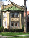 | March 15, 1984 (#84000980) | 2517 Central St. 42°03′53″N 87°42′31″W / 42.064722°N 87.708611°W / 42.064722; -87.708611 (Building at 2517 Central Street) | ||
| 11 | Building at 2519 Central Street |  | March 15, 1984 (#84000982) | 2519 Central St. 42°03′53″N 87°42′33″W / 42.064722°N 87.709167°W / 42.064722; -87.709167 (Building at 2519 Central Street) | ||
| 12 | Building at 2523 Central Street | 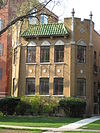 | March 15, 1984 (#84000983) | 2523 Central St. 42°03′53″N 87°42′35″W / 42.064722°N 87.709722°W / 42.064722; -87.709722 (Building at 2523 Central Street) | ||
| 13 | Building at 417–419 Lee Street |  | March 15, 1984 (#84000942) | 417–419 Lee St. 42°02′10″N 87°40′39″W / 42.036111°N 87.6775°W / 42.036111; -87.6775 (Building at 417–419 Lee Street) | ||
| 14 | Building at 548–606 Michigan Avenue |  | March 15, 1984 (#84000945) | 548–606 Michigan Ave. 42°01′43″N 87°40′21″W / 42.028611°N 87.6725°W / 42.028611; -87.6725 (Building at 548–606 Michigan Avenue) | ||
| 15 | Building at 813–815 Forest Avenue |  | March 15, 1984 (#84000950) | 813–815 Forest Ave. 42°01′58″N 87°40′26″W / 42.032778°N 87.673889°W / 42.032778; -87.673889 (Building at 813–815 Forest Avenue) | ||
| 16 | Building at 923–925 Michigan Avenue | 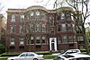 | March 15, 1984 (#84000953) | 923–925 Michigan Ave. 42°02′05″N 87°40′23″W / 42.034722°N 87.673056°W / 42.034722; -87.673056 (Building at 923–925 Michigan Avenue) | ||
| 17 | Building at 999 Michigan, 200 Lee |  | March 15, 1984 (#84000958) | 999 Michigan Ave., 200 Lee St. 42°02′08″N 87°40′24″W / 42.035556°N 87.673333°W / 42.035556; -87.673333 (Building at 999 Michigan, 200 Lee) | ||
| 18 | Buildings at 1104–1110 Seward |  | September 2, 1986 (#86001743) | 1104–1110 Seward 42°01′44″N 87°41′16″W / 42.028889°N 87.687778°W / 42.028889; -87.687778 (Buildings at 1104–1110 Seward) | ||
| 19 | Buildings at 815–817 Brummel and 819–821 Brummel |  | March 15, 1984 (#84000952) | 815–817, and 819–821 Brummel St. 42°01′17″N 87°41′04″W / 42.021389°N 87.684444°W / 42.021389; -87.684444 (Buildings at 815–817 Brummel and 819–821 Brummel) | ||
| 20 | Frederick B. Carter, Jr. House |  | July 30, 1974 (#74000758) | 1024 Judson Ave. 42°02′11″N 87°40′37″W / 42.036389°N 87.676944°W / 42.036389; -87.676944 (Frederick B. Carter, Jr. House) | 1910 Prairie School style house, designed by Walter Burley Griffin. | |
| 21 | Castle Tower Apartments |  | March 15, 1984 (#84000985) | 2212-2226 Sherman Ave. 42°03′30″N 87°40′56″W / 42.058333°N 87.682222°W / 42.058333; -87.682222 (Castle Tower Apartments) | ||
| 22 | Colonnade Court |  | March 15, 1984 (#84000987) | 501-507 Main St., 904-908 Hinman Ave. 42°02′06″N 87°40′43″W / 42.035°N 87.678611°W / 42.035; -87.678611 (Colonnade Court) | ||
| 23 | Charles Gates Dawes House |  | December 8, 1976 (#76000706) | 225 Greenwood St. 42°02′35″N 87°40′25″W / 42.043056°N 87.673611°W / 42.043056; -87.673611 (Charles Gates Dawes House) | Home of the Evanston History Center | |
| 24 | George B. Dryden House |  | December 18, 1978 (#78001135) | 1314 Ridge Ave. 42°02′30″N 87°41′21″W / 42.041667°N 87.689167°W / 42.041667; -87.689167 (George B. Dryden House) | ||
| 25 | Evanston Lakeshore Historic District |  | September 29, 1980 (#80001353) | Roughly bounded by Northwestern University, Lake Michigan, Calvary Cemetery, and Chicago Ave. 42°02′15″N 87°40′30″W / 42.0375°N 87.675°W / 42.0375; -87.675 (Evanston Lakeshore Historic District) | ||
| 26 | Evanston Ridge Historic District | 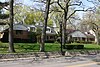 | March 3, 1983 (#83000309) | Roughly bounded by Main, Asbury, Ashland, Emerson, Ridge Ave and Maple Ave. 42°02′35″N 87°41′21″W / 42.043056°N 87.689167°W / 42.043056; -87.689167 (Evanston Ridge Historic District) | ||
| 27 | Evanston Towers |  | March 15, 1984 (#84000990) | 554-602 Sheridan Sq. 42°01′43″N 87°40′10″W / 42.028611°N 87.669444°W / 42.028611; -87.669444 (Evanston Towers) | ||
| 28 | The Forest and Annex |  | March 15, 1984 (#84000991) | 901-905 Forest Ave. 42°02′02″N 87°40′27″W / 42.033889°N 87.674167°W / 42.033889; -87.674167 (The Forest and Annex) | ||
| 29 | Fountain Plaza Apartments |  | March 15, 1984 (#84000992) | 830-856 Hinman Ave. 42°02′00″N 87°40′42″W / 42.033333°N 87.678333°W / 42.033333; -87.678333 (Fountain Plaza Apartments) | ||
| 30 | The Greenwood | 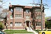 | March 15, 1984 (#84000993) | 425 Greenwood St. 42°02′35″N 87°40′44″W / 42.043056°N 87.678889°W / 42.043056; -87.678889 (The Greenwood) | ||
| 31 | Grosse Point Light Station |  | September 8, 1976 (#76000707) | 2601 Sheridan Rd. 42°03′50″N 87°40′34″W / 42.063889°N 87.676111°W / 42.063889; -87.676111 (Grosse Point Light Station) | ||
| 32 | Hillcrest Apartment | 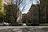 | March 15, 1984 (#84000994) | 1509-1515 Hinman Ave. 42°02′42″N 87°40′41″W / 42.044955°N 87.677964°W / 42.044955; -87.677964 (Hillcrest Apartment) | ||
| 33 | Hinman Apartments |  | March 15, 1984 (#84000995) | 1629-1631 Hinman Ave. 42°02′48″N 87°40′39″W / 42.046667°N 87.6775°W / 42.046667; -87.6775 (Hinman Apartments) | ||
| 34 | The Homestead |  | February 1, 2006 (#05001607) | 1625 Hinman Ave. 42°02′48″N 87°40′38″W / 42.046555°N 87.677271°W / 42.046555; -87.677271 (The Homestead) | ||
| 35 | James B. Irving House | Upload image | February 5, 2021 (#100006102) | 2771 Crawford Ave. 42°04′08″N 87°43′50″W / 42.068938°N 87.730591°W / 42.068938; -87.730591 (James B. Irving House) | ||
| 36 | The Judson |  | March 15, 1984 (#84000998) | 1243-1249 Judson Ave. 42°02′27″N 87°40′35″W / 42.040833°N 87.676389°W / 42.040833; -87.676389 (The Judson) | ||
| 37 | Lake Shore Apartments |  | March 15, 1984 (#84001000) | 470-498 Sheridan Rd. 42°01′37″N 87°40′07″W / 42.026944°N 87.668611°W / 42.026944; -87.668611 (Lake Shore Apartments) | ||
| 38 | Maple Court Apartments |  | March 15, 1984 (#84001013) | 1115-1133 Maple Ave. 42°02′20″N 87°41′06″W / 42.038889°N 87.685°W / 42.038889; -87.685 (Maple Court Apartments) | ||
| 39 | Marywood Academy |  | February 9, 2006 (#06000007) | 2100 Ridge Ave. 42°03′24″N 87°41′14″W / 42.056715°N 87.687190°W / 42.056715; -87.687190 (Marywood Academy) | A former Catholic girls school which is now home to the Evanston Civic Center [4] | |
| 40 | Melwood Apartments |  | March 15, 1984 (#84001016) | 1201-1213 Michigan Ave. and 205-207 Hamilton St. 42°02′22″N 87°40′24″W / 42.039444°N 87.673333°W / 42.039444; -87.673333 (Melwood Apartments) | ||
| 41 | Michigan-Lee Apartments |  | March 15, 1984 (#84001018) | 940-950 Michigan Ave. 42°02′07″N 87°40′26″W / 42.035278°N 87.673889°W / 42.035278; -87.673889 (Michigan-Lee Apartments) | ||
| 42 | Northeast Evanston Historic District |  | August 12, 1999 (#99000979) | Roughly bounded by Emerson St., Sherman Ave., Sheridan Pl., Lake Michigan, Sheridan Rd., and Orrington Ave. 42°03′40″N 87°40′47″W / 42.061111°N 87.679722°W / 42.061111; -87.679722 (Northeast Evanston Historic District) | ||
| 43 | Oak Ridge Apartments |  | March 15, 1984 (#84001025) | 1615-1625 Ridge Ave. 42°02′51″N 87°41′19″W / 42.0475°N 87.688611°W / 42.0475; -87.688611 (Oak Ridge Apartments) | ||
| 44 | Oakton Gables |  | March 15, 1984 (#84001024) | 900-910 Oakton St. and 439-445 Ridge Ave. 42°01′35″N 87°41′07″W / 42.026389°N 87.685278°W / 42.026389; -87.685278 (Oakton Gables) | ||
| 45 | Oakton Historic District |  | May 23, 2005 (#05000106) | Roughly bounded by Oakton St., Howard St., Ridge Ave., and Asbury Ave. 42°01′31″N 87°41′15″W / 42.025278°N 87.6875°W / 42.025278; -87.6875 (Oakton Historic District) | ||
| 46 | Dwight Perkins House |  | August 29, 1985 (#85001908) | 2319 Lincoln St. 42°03′44″N 87°42′47″W / 42.062222°N 87.713056°W / 42.062222; -87.713056 (Dwight Perkins House) | ||
| 47 | Raymond Park Apartments | 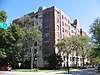 | April 12, 2002 (#85003581) | 1501 Hinman Ave. and 425 Grove St. 42°02′41″N 87°40′42″W / 42.044722°N 87.678333°W / 42.044722; -87.678333 (Raymond Park Apartments) | ||
| 48 | Ridge Boulevard Apartments |  | March 15, 1984 (#84001028) | 843-849 Ridge Ave. and 1014-1020 Main St. 42°02′02″N 87°41′12″W / 42.033889°N 87.686667°W / 42.033889; -87.686667 (Ridge Boulevard Apartments) | ||
| 49 | Ridge Grove | 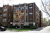 | March 15, 1984 (#84001030) | 1112 Grove St. 42°02′43″N 87°41′16″W / 42.045278°N 87.687778°W / 42.045278; -87.687778 (Ridge Grove) | ||
| 50 | Ridge Manor |  | March 15, 1984 (#84001034) | 1603-1611 Ridge Ave. and 1125 Davis St. 42°02′51″N 87°41′19″W / 42.0475°N 87.688611°W / 42.0475; -87.688611 (Ridge Manor) | ||
| 51 | Ridgewood |  | October 4, 1978 (#78001136) | 1703-1713 Ridge Ave. 42°02′56″N 87°41′18″W / 42.048889°N 87.688333°W / 42.048889; -87.688333 (Ridgewood) | ||
| 52 | Rookwood Apartments | 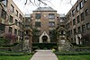 | March 15, 1984 (#84001043) | 718-734 Noyes St. 42°03′30″N 87°40′53″W / 42.058333°N 87.681389°W / 42.058333; -87.681389 (Rookwood Apartments) | ||
| 53 | Roycemore School |  | August 3, 1987 (#87001256) | 640 Lincoln St. 42°03′41″N 87°40′44″W / 42.061389°N 87.678889°W / 42.061389; -87.678889 (Roycemore School) | ||
| 54 | Shakespeare Garden |  | November 16, 1988 (#88002234) | Northwestern University campus 42°03′24″N 87°40′34″W / 42.056667°N 87.676111°W / 42.056667; -87.676111 (Shakespeare Garden) | ||
| 55 | Sheridan Square Apartments |  | March 15, 1984 (#84001050) | 620-638 Sheridan Sq. 42°01′44″N 87°40′11″W / 42.028889°N 87.669722°W / 42.028889; -87.669722 (Sheridan Square Apartments) | ||
| 56 | Stoneleigh Manor |  | March 15, 1984 (#84001057) | 904-906 Michigan Ave. and 227-229 Main St. 42°02′02″N 87°40′25″W / 42.033889°N 87.673611°W / 42.033889; -87.673611 (Stoneleigh Manor) | ||
| 57 | Tudor Manor |  | March 15, 1984 (#84001058) | 524 Sheridan Sq. 42°01′39″N 87°40′09″W / 42.0275°N 87.669167°W / 42.0275; -87.669167 (Tudor Manor) | ||
| 58 | Edward Kirk Warren House and Garage | 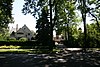 | January 30, 1986 (#86000136) | 2829 and 2831 Sheridan Pl. 42°04′10″N 87°40′46″W / 42.069444°N 87.679444°W / 42.069444; -87.679444 (Edward Kirk Warren House and Garage) | ||
| 59 | Westminster |  | March 15, 1984 (#84001061) | 632-640 Hinman Ave. 42°01′47″N 87°40′39″W / 42.029722°N 87.6775°W / 42.029722; -87.6775 (Westminster) | ||
| 60 | Frances Willard House | 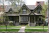 | October 15, 1966 (#66000318) | 1730 Chicago Ave. 42°02′54″N 87°40′45″W / 42.048333°N 87.679167°W / 42.048333; -87.679167 (Frances Willard House) | ||
| 61 | Woman's Christian Temperance Union Administration Building |  | August 13, 2002 (#02000849) | 1730R Chicago Ave. 42°02′56″N 87°40′45″W / 42.048973°N 87.679151°W / 42.048973; -87.679151 (Woman's Christian Temperance Union Administration Building) | ||
| 62 | Woman's Club of Evanston | 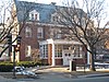 | November 9, 2006 (#06001020) | 1702 Chicago Ave. 42°02′53″N 87°40′45″W / 42.048136°N 87.679063°W / 42.048136; -87.679063 (Woman's Club of Evanston) |
Wikimedia Commons has media related to National Register of Historic Places in Evanston, Illinois.
References
- ^ Numbers represent an alphabetical ordering by significant words. Various colorings, defined here, differentiate National Historic Landmarks and historic districts from other NRHP buildings, structures, sites or objects.
- ^ "National Register Information System". National Register of Historic Places. National Park Service. January 23, 2007.
- ^ The eight-digit number below each date is the number assigned to each location in the National Register Information System database, which can be viewed by clicking the number.
- ^ http://www.cityofevanston.org/government/council/civic.shtml#Marywood Evanston Civic Center History
- v
- t
- e
- Central Street
- Evanston/Skokie School District 65
- Evanston Township High School
- Roycemore School
- Northwestern University
- template
- Oakton College (operates no facilities in Evanston, but Evanston is in its service area)
- Evanston Public Library
| Closed |
|---|
- Ladd Arboretum
- Mount Trashmore
- Andridge Apartments
- Frederick B. Carter Jr. House
- Charles G. Dawes House
- George B. Dryden House
- Evanston Towers
- Grosse Point Light(house)
- Marywood Academy
- Dwight Perkins House
- Ridgewood
- Old Roycemore School building
- Shakespeare Garden
- Edward Kirk Warren House and Garage
- Frances Willard House (Evanston, Illinois)
- Woman's Christian Temperance Union Administration Building
- Woman's Club of Evanston
This list is incomplete.


