National Register of Historic Places listings in Grant County, Washington

This list presents the full set of buildings, structures, objects, sites, or districts designated on the National Register of Historic Places in Grant County, Washington, and offers brief descriptive information about each of them. The National Register recognizes places of national, state, or local historic significance across the United States.[1] Out of over 90,000 National Register sites nationwide,[2] Washington is home to approximately 1,500,[3] and 11 of those are found partially or wholly in Grant County.
This National Park Service list is complete through NPS recent listings posted June 7, 2024.[4]
Current listings
| [5] | Name on the Register | Image | Date listed[6] | Location | City or town | Description |
|---|---|---|---|---|---|---|
| 1 | Bell Hotel |  | September 15, 1997 (#97001082) | 210 W. Division St. 47°19′14″N 119°33′04″W / 47.320556°N 119.551111°W / 47.320556; -119.551111 (Bell Hotel) | Ephrata | |
| 2 | Beverly Railroad Bridge |  | July 16, 1982 (#82004214) | Spans Columbia River 46°49′52″N 119°56′54″W / 46.831111°N 119.948333°W / 46.831111; -119.948333 (Beverly Railroad Bridge) | Beverly | |
| 3 | Columbia Basin Project Irrigation Division Headquarters Office | 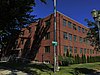 | June 21, 2019 (#100004099) | 32 C St. NW 47°19′17″N 119°33′10″W / 47.3214°N 119.5529°W / 47.3214; -119.5529 (Columbia Basin Project Irrigation Division Headquarters Office) | Ephrata | |
| 4 | Grant County Courthouse |  | September 5, 1975 (#75001850) | C St., NW 47°19′19″N 119°33′08″W / 47.321944°N 119.552222°W / 47.321944; -119.552222 (Grant County Courthouse) | Ephrata | |
| 5 | Hartline School |  | January 7, 2010 (#09001217) | 92 Chelan Street 47°41′12″N 119°06′30″W / 47.686667°N 119.108333°W / 47.686667; -119.108333 (Hartline School) | Hartline | |
| 6 | Lind Coulee Archaeological Site | 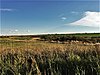 | January 21, 1974 (#74001953) | Address Restricted | Warden | |
| 7 | Mesa 36 |  | December 8, 1978 (#78002744) | Address Restricted | Soap Lake | |
| 8 | Paris Archeological Site | Upload image | September 20, 1978 (#78002743) | Address Restricted | Richland | |
| 9 | Samuel and Katherine Reiman House |  | December 17, 2008 (#08001201) | 415 F. St. SW. 47°14′01″N 119°51′40″W / 47.2337°N 119.8610°W / 47.2337; -119.8610 (Samuel and Katherine Reiman House) | Quincy | Now used as a museum |
| 10 | Stratford School |  | October 25, 1990 (#90001606) | Just off WA 7 47°25′36″N 119°16′24″W / 47.426667°N 119.273333°W / 47.426667; -119.273333 (Stratford School) | Stratford | Rural Public Schools of Washington State MPS |
| 11 | Wilson Creek State Bank |  | September 25, 1975 (#75001851) | Off WA 7 47°25′23″N 119°07′14″W / 47.423056°N 119.120556°W / 47.423056; -119.120556 (Wilson Creek State Bank) | Wilson Creek | Built in 1906. Currently houses local history museum. |
See also
- National Register of Historic Places listings in Washington state
- Listings in neighboring counties: Adams, Benton, Douglas, Franklin, Kittitas, Lincoln, Okanogan, Yakima
- Historic preservation
- History of Washington (state)
- Index of Washington (state)-related articles
References
- ^ Andrus, Patrick W.; Shrimpton, Rebecca H.; et al. (2002). "How to Apply the National Register Criteria for Evaluation". National Register Bulletin. National Park Service, U.S. Department of the Interior. Retrieved June 20, 2014.
- ^ National Park Service. "National Register of Historic Places Program: Research". Retrieved January 28, 2015.
- ^ Department of Archaeology and Historic Preservation. "Washington Information System for Architectural and Archaeological Records Data (WISAARD)". Retrieved February 14, 2015.
- ^ National Park Service, United States Department of the Interior, "National Register of Historic Places: Weekly List Actions", retrieved June 7, 2024.
- ^ Numbers represent an alphabetical ordering by significant words. Various colorings, defined here, differentiate National Historic Landmarks and historic districts from other NRHP buildings, structures, sites or objects.
- ^ The eight-digit number below each date is the number assigned to each location in the National Register Information System database, which can be viewed by clicking the number.
External links
Map all coordinates using OpenStreetMap
Download coordinates as:
- KML
- GPX (all coordinates)
- GPX (primary coordinates)
- GPX (secondary coordinates)
- Washington Department of Archaeology and Historic Preservation, Historic Register program
- National Park Service, National Register of Historic Places site
 Media related to National Register of Historic Places in Grant County, Washington at Wikimedia Commons
- v
- t
- e
National Register of Historic Places listings in Washington (state)
by county
- Adams
- Asotin
- Benton
- Chelan
- Clallam
- Clark
- Columbia
- Cowlitz
- Douglas
- Ferry
- Franklin
- Garfield
- Grant
- Grays Harbor
- Island
- Jefferson
- King
- Kitsap
- Kittitas
- Lewis
- Lincoln
- Mason
- Okanogan
- Pacific
- Pend Oreille
- Pierce
- San Juan
- Skagit
- Skamania
- Snohomish
- Spokane
- Stevens
- Thurston
- Wahkiakum
- Walla Walla
- Whatcom
- Whitman
- Yakima

- National Historic Landmarks
- Bridges and Tunnels
| |
|---|---|
| Topics | |
| Lists by state |
|
| Lists by insular areas | |
| Lists by associated state | |
| Other areas | |
| Related | |
| |


Municipalities and communities of Grant County, Washington, United States | ||
|---|---|---|
County seat: Ephrata | ||
| Cities |  | |
| Towns | ||
| CDPs | ||
| Other communities | ||
| Ghost towns | ||
| Footnotes | ‡This populated place also has portions in an adjacent county or counties | |
| ||


