National Register of Historic Places listings in Howard County, Missouri

This is a list of the National Register of Historic Places listings in Howard County, Missouri.
This is intended to be a complete list of the properties and districts on the National Register of Historic Places in Howard County, Missouri, United States. Latitude and longitude coordinates are provided for many National Register properties and districts; these locations may be seen together in a map.[1]
There are 25 properties and districts listed on the National Register in the county.
This National Park Service list is complete through NPS recent listings posted June 7, 2024.[2]
Map all coordinates using OpenStreetMap
Download coordinates as:
- KML
- GPX (all coordinates)
- GPX (primary coordinates)
- GPX (secondary coordinates)
Current listings
| [3] | Name on the Register | Image | Date listed[4] | Location | City or town | Description |
|---|---|---|---|---|---|---|
| 1 | Edwin and Nora Payne Bedford House |  | January 23, 1998 (#97001666) | 308 S. Main St. 39°08′39″N 92°40′51″W / 39.144167°N 92.680791°W / 39.144167; -92.680791 (Edwin and Nora Payne Bedford House) | Fayette | |
| 2 | Boonslick State Park | 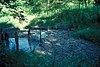 | December 30, 1969 (#69000104) | 1 mile (1.6 km) north of Boonesboro on MO 87, 2 miles (3.2 km) southwest on MO 187 39°05′01″N 92°52′44″W / 39.083611°N 92.878889°W / 39.083611; -92.878889 (Boonslick State Park) | Boonesboro | |
| 3 | Campbell Chapel African Methodist Episcopal Church |  | November 13, 1997 (#97001427) | 602 Commerce St. 39°13′36″N 92°50′29″W / 39.226667°N 92.841389°W / 39.226667; -92.841389 (Campbell Chapel African Methodist Episcopal Church) | Glasgow | |
| 4 | Cedar Grove |  | July 19, 1982 (#82003140) | West of Franklin 39°00′35″N 92°47′57″W / 39.009722°N 92.799167°W / 39.009722; -92.799167 (Cedar Grove) | Franklin | |
| 5 | Central Methodist College Campus Historic District | 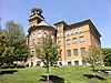 | September 15, 1980 (#80002357) | Roughly bounded by Mulberry, Elm, Church and MO 5 39°09′01″N 92°41′07″W / 39.150380°N 92.685380°W / 39.150380; -92.685380 (Central Methodist College Campus Historic District) | Fayette | |
| 6 | Coleman Hall | 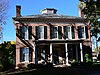 | June 11, 1986 (#86001326) | 502 N. Linn 39°08′55″N 92°41′10″W / 39.148611°N 92.686111°W / 39.148611; -92.686111 (Coleman Hall) | Fayette | |
| 7 | Fayette City Park Swimming Pool |  | April 15, 1999 (#99000457) | Memorial Park 39°09′07″N 92°41′42″W / 39.151944°N 92.695°W / 39.151944; -92.695 (Fayette City Park Swimming Pool) | Fayette | |
| 8 | Fayette Courthouse Square Historic District |  | February 5, 1998 (#98000069) | Roughly along S. Main and N. Main, W. Morrison, E. Morrison, N. Church, and W. Davis Sts. 39°08′45″N 92°40′57″W / 39.145833°N 92.6825°W / 39.145833; -92.6825 (Fayette Courthouse Square Historic District) | Fayette | |
| 9 | Fayette Residential Historic District | Upload image | September 3, 2009 (#09000681) | Roughly bounded by Church Street, West Morrison Street and Cleveland Avenue 39°08′35″N 92°41′08″W / 39.143056°N 92.685556°W / 39.143056; -92.685556 (Fayette Residential Historic District) | Fayette | |
| 10 | Finks-Harvey Plantation | Upload image | December 11, 1978 (#78001649) | West of Roanoke 39°19′20″N 92°45′11″W / 39.322222°N 92.753056°W / 39.322222; -92.753056 (Finks-Harvey Plantation) | Roanoke | |
| 11 | Glasgow Commercial Historic District |  | January 16, 1992 (#91001915) | 501-623 First St., 100-195 Market St., 603 Second St. 39°13′35″N 92°50′48″W / 39.226389°N 92.846667°W / 39.226389; -92.846667 (Glasgow Commercial Historic District) | Glasgow | |
| 12 | Glasgow Presbyterian Church |  | September 9, 1982 (#82003141) | Commerce and 4th Sts. 39°13′36″N 92°50′36″W / 39.226667°N 92.843333°W / 39.226667; -92.843333 (Glasgow Presbyterian Church) | Glasgow | |
| 13 | Glasgow Public Library |  | May 21, 1969 (#69000106) | NW corner Market and 4th Sts. 39°13′34″N 92°50′36″W / 39.226111°N 92.843333°W / 39.226111; -92.843333 (Glasgow Public Library) | Glasgow | |
| 14 | Greenwood |  | March 29, 1983 (#83000994) | MO 5 39°03′49″N 92°45′04″W / 39.063611°N 92.751111°W / 39.063611; -92.751111 (Greenwood) | Fayette | |
| 15 | Harris-Chilton-Ruble House | 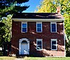 | September 4, 1980 (#80002359) | 108 N. Missouri Ave. 39°01′12″N 92°44′28″W / 39.02°N 92.741111°W / 39.02; -92.741111 (Harris-Chilton-Ruble House) | New Franklin | |
| 16 | Thomas Hickman House | Upload image | July 19, 2006 (#06000627) | 10 Research Center Rd. 39°01′22″N 92°45′37″W / 39.022778°N 92.760278°W / 39.022778; -92.760278 (Thomas Hickman House) | New Franklin | |
| 17 | Inglewood | Upload image | June 21, 1990 (#90000981) | 701 Randolph St. 39°13′48″N 92°50′18″W / 39.23°N 92.838333°W / 39.23; -92.838333 (Inglewood) | Glasgow | |
| 18 | Prior Jackson Homeplace | Upload image | March 10, 1980 (#80002358) | South of Fayette on MO DD 39°08′03″N 92°41′20″W / 39.134167°N 92.688889°W / 39.134167; -92.688889 (Prior Jackson Homeplace) | Fayette | |
| 19 | Alfred W. Morrison House | Upload image | April 16, 1969 (#69000105) | 1 mile (1.6 km) southwest of Fayette on MO 5 39°08′03″N 92°41′36″W / 39.134167°N 92.693333°W / 39.134167; -92.693333 (Alfred W. Morrison House) | Fayette | |
| 20 | New Franklin Commercial Historic District |  | January 23, 2013 (#12001207) | 106-136 & 101-113 E. Broadway 39°01′02″N 92°44′12″W / 39.0173°N 92.736651°W / 39.0173; -92.736651 (New Franklin Commercial Historic District) | New Franklin | |
| 21 | Oakwood |  | September 23, 1982 (#82003138) | 1 Leonard Ave. 39°08′51″N 92°40′34″W / 39.1475°N 92.676111°W / 39.1475; -92.676111 (Oakwood) | Fayette | |
| 22 | Rivercene | Upload image | February 16, 1973 (#73001039) | R.F.D. 1 38°59′08″N 92°44′30″W / 38.985556°N 92.741667°W / 38.985556; -92.741667 (Rivercene) | New Franklin | |
| 23 | St. Mary's Episcopal Church |  | September 9, 1982 (#82003139) | 104 W. Davis St. 39°08′46″N 92°41′06″W / 39.146111°N 92.685°W / 39.146111; -92.685 (St. Mary's Episcopal Church) | Fayette | |
| 24 | South Main Street Historic District | 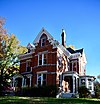 | February 5, 1999 (#99000083) | 200, 202, 204, and 208-312 South Main St. 39°08′37″N 92°40′50″W / 39.143611°N 92.680556°W / 39.143611; -92.680556 (South Main Street Historic District) | Fayette | |
| 25 | Dr. Uriel S. Wright Office |  | December 22, 1987 (#87001727) | 120 Church St. 39°08′49″N 92°41′01″W / 39.146944°N 92.683611°W / 39.146944; -92.683611 (Dr. Uriel S. Wright Office) | Fayette |
See also
- List of National Historic Landmarks in Missouri
- National Register of Historic Places listings in Missouri
References
Wikimedia Commons has media related to National Register of Historic Places in Howard County, Missouri.
- ^ The latitude and longitude information provided in this table was derived originally from the National Register Information System, which has been found to be fairly accurate for about 99% of listings. Some locations in this table may have been corrected to current GPS standards.
- ^ National Park Service, United States Department of the Interior, "National Register of Historic Places: Weekly List Actions", retrieved June 7, 2024.
- ^ Numbers represent an alphabetical ordering by significant words. Various colorings, defined here, differentiate National Historic Landmarks and historic districts from other NRHP buildings, structures, sites or objects.
- ^ The eight-digit number below each date is the number assigned to each location in the National Register Information System database, which can be viewed by clicking the number.
- v
- t
- e
- List of U.S. National Historic Landmarks by state:
- Alabama
- Alaska
- Arizona
- Arkansas
- California
- Colorado
- Connecticut
- Delaware
- Florida
- Georgia
- Hawaii
- Idaho
- Illinois
- Indiana
- Iowa
- Kansas
- Kentucky
- Louisiana
- Maine
- Maryland
- Massachusetts
- Michigan
- Minnesota
- Mississippi
- Missouri
- Montana
- Nebraska
- Nevada
- New Hampshire
- New Jersey
- New Mexico
- New York
- North Carolina
- North Dakota
- Ohio
- Oklahoma
- Oregon
- Pennsylvania
- Rhode Island
- South Carolina
- South Dakota
- Tennessee
- Texas
- Utah
- Vermont
- Virginia
- Washington
- West Virginia
- Wisconsin
- Wyoming
 National Register of Historic Places portal
 Category


Municipalities and communities of Howard County, Missouri, United States | ||
|---|---|---|
County seat: Fayette | ||
| Cities |  | |
| Townships | ||
| Unincorporated communities | ||
| Ghost town | ||
| Footnotes | ‡This populated place also has portions in an adjacent county or counties | |
| ||


