National Register of Historic Places listings in Iron County, Utah
This is a list of the National Register of Historic Places listings in Iron County, Utah.
This is intended to be a complete list of the properties and districts on the National Register of Historic Places in Iron County, Utah, United States. Latitude and longitude coordinates are provided for many National Register properties and districts; these locations may be seen together in a map.[1]
There are 18 properties and districts listed on the National Register in the county. Two other sites in the county were once listed on the Register, but have since been removed.
This National Park Service list is complete through NPS recent listings posted May 31, 2024.[2]
Map all coordinates using OpenStreetMap
Download coordinates as:
- KML
- GPX (all coordinates)
- GPX (primary coordinates)
- GPX (secondary coordinates)
Current listings
| [3] | Name on the Register[4] | Image | Date listed[5] | Location | City or town | Description |
|---|---|---|---|---|---|---|
| 1 | Caretaker's Cabin | August 4, 1983 (#83004385) | Off State Route 14 37°36′55″N 112°50′12″W / 37.615278°N 112.836667°W / 37.615278; -112.836667 (Caretaker's Cabin) | Cedar City | ||
| 2 | Cedar City Historic District |  | July 7, 2004 (#04000677) | Roughly bounded by 100 West and 300 West, College Ave., and 400 South 37°40′23″N 113°03′51″W / 37.673056°N 113.064167°W / 37.673056; -113.064167 (Cedar City Historic District) | Cedar City | |
| 3 | Cedar City Railroad Depot | 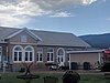 | August 9, 1984 (#84002184) | 220 N. Main St. 37°40′53″N 113°03′41″W / 37.681389°N 113.061389°W / 37.681389; -113.061389 (Cedar City Railroad Depot) | Cedar City | |
| 4 | Ensign-Smith House | 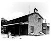 | May 19, 1983 (#83004400) | 96 N. Main St. 37°53′12″N 112°46′26″W / 37.886667°N 112.773889°W / 37.886667; -112.773889 (Ensign-Smith House) | Paragonah | |
| 5 | Evans Mound (42IN40) | Upload image | October 24, 1985 (#85003387) | Address Restricted[6] | Summit | |
| 6 | Gold Spring | Upload image | July 21, 1977 (#77001305) | Address Restricted[6] | Modena | |
| 7 | Long Flat Site | Upload image | November 1, 1979 (#79002496) | Address Restricted[6] | Parowan | |
| 8 | William and Julia Lyman House | 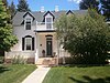 | April 6, 2000 (#00000355) | 191 S. Main St. 37°50′22″N 112°49′35″W / 37.839444°N 112.826389°W / 37.839444; -112.826389 (William and Julia Lyman House) | Parowan | |
| 9 | Meeks-Green Farmstead | 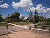 | April 15, 1994 (#94000295) | Approximately 40 N. 400 West 37°50′34″N 112°50′08″W / 37.842778°N 112.835556°W / 37.842778; -112.835556 (Meeks-Green Farmstead) | Parowan | |
| 10 | Modena Elementary School |  | April 1, 1985 (#85000806) | About 150 N. Main St. 37°48′00″N 113°55′29″W / 37.8°N 113.924722°W / 37.8; -113.924722 (Modena Elementary School) | Modena | |
| 11 | Old Irontown | 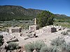 | May 14, 1971 (#71000843) | About 22 miles (35 km) west of Cedar City, 3 miles (4.8 km) south of State Route 56 37°36′00″N 113°26′56″W / 37.6°N 113.448889°W / 37.6; -113.448889 (Old Irontown) | Cedar City | |
| 12 | Old Main and Science Buildings | 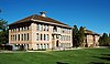 | August 21, 1984 (#84002186) | Southern Utah University campus 37°40′32″N 113°04′03″W / 37.675556°N 113.0675°W / 37.675556; -113.0675 (Old Main and Science Buildings) | Cedar City | |
| 13 | Daniel R. and Sophia G. Page House | 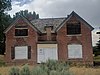 | May 9, 1985 (#85000961) | Richie Flat at the western edge of the Harmony Mountains 37°34′03″N 113°25′24″W / 37.5675°N 113.423333°W / 37.5675; -113.423333 (Daniel R. and Sophia G. Page House) | Newcastle | |
| 14 | Parowan Gap Petroglyphs | 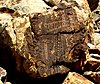 | October 10, 1975 (#75001806) | 10.5 miles (16.9 km) west of Main Street in Parowan[7] 37°54′35″N 112°59′07″W / 37.909722°N 112.985278°W / 37.909722; -112.985278 (Parowan Gap Petroglyphs) | Parowan | |
| 15 | Parowan Meetinghouse | 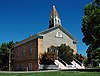 | May 6, 1976 (#76001818) | Center block of Main St., between Center and 100 South St. 37°50′28″N 112°49′41″W / 37.841111°N 112.828056°W / 37.841111; -112.828056 (Parowan Meetinghouse) | Parowan | |
| 16 | Jesse N. Smith House | 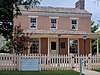 | June 20, 1975 (#75001807) | 45 W. 100 South 37°50′24″N 112°49′39″W / 37.84°N 112.8275°W / 37.84; -112.8275 (Jesse N. Smith House) | Parowan | |
| 17 | US Post Office-Cedar City Main |  | November 27, 1989 (#89001993) | 10 N. Main St. 37°40′39″N 113°03′39″W / 37.6775°N 113.060833°W / 37.6775; -113.060833 (US Post Office-Cedar City Main) | Cedar City | Now houses city offices |
| 18 | Visitor Center | 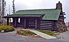 | August 4, 1983 (#83004386) | Off State Route 14 37°37′09″N 112°50′12″W / 37.619167°N 112.836667°W / 37.619167; -112.836667 (Visitor Center) | Cedar City |
Former listing
| [3] | Name on the Register | Image | Date listed | Date removed | Location | City or town | Description |
|---|---|---|---|---|---|---|---|
| 1 | Joseph S. Hunter House | Upload image | February 11, 1982 (#82004126) | February 21, 2007 | 86 E. Center St.(Original location. Now located at:) 37°41′20″N 113°03′48″W / 37.6888515°N 113.063228°W / 37.6888515; -113.063228 (Joseph S. Hunter House) | Cedar City | Delisted when the house was moved to Iron Mission State Park.[8] |
| 2 | George H. Wood House | Upload image | November 14, 1978 (#78002662) | August 15, 2023 | 432 N. Main St. 37°41′06″N 113°03′39″W / 37.685°N 113.060833°W / 37.685; -113.060833 (George H. Wood House) | Cedar City |
See also
References
- ^ The latitude and longitude information provided in this table was derived originally from the National Register Information System, which has been found to be fairly accurate for about 99% of listings. Some locations in this table may have been corrected to current GPS standards.
- ^ National Park Service, United States Department of the Interior, "National Register of Historic Places: Weekly List Actions", retrieved May 31, 2024.
- ^ a b Numbers represent an alphabetical ordering by significant words. Various colorings, defined here, differentiate National Historic Landmarks and historic districts from other NRHP buildings, structures, sites or objects.
- ^ "National Register Information System". National Register of Historic Places. National Park Service. April 24, 2008.
- ^ The eight-digit number below each date is the number assigned to each location in the National Register Information System database, which can be viewed by clicking the number.
- ^ a b c Some listings on the NRHP are highly sensitive sites and may be subject to looting or vandalism. The NRHP lists this site as "Address Restricted."
- ^ "The Parowan Gap".
- ^ "Patience a virtue with efforts to move historic house". The Spectrum (Utah). December 10, 2005. p. 9. Retrieved August 30, 2022 – via Newspapers.com.
External links
![]() Media related to National Register of Historic Places in Iron County, Utah at Wikimedia Commons
Media related to National Register of Historic Places in Iron County, Utah at Wikimedia Commons
- v
- t
- e

| |
|---|---|
| Topics | |
| Lists by state |
|
| Lists by insular areas | |
| Lists by associated state | |
| Other areas | |
| Related | |
| |


Municipalities and communities of Iron County, Utah, United States | ||
|---|---|---|
County seat: Parowan | ||
| Cities |  | |
| Towns | ||
| CDPs | ||
| Other communities | ||
| Ghost town | ||
| Indian reservation | ||
| Footnotes | ‡This populated place also has portions in an adjacent county or counties | |
| ||


