National Register of Historic Places listings in Johnston County, North Carolina
Map all coordinates using OpenStreetMap
Download coordinates as:
- KML
- GPX (all coordinates)
- GPX (primary coordinates)
- GPX (secondary coordinates)

This list includes properties and districts listed on the National Register of Historic Places in Johnston County, North Carolina. Click the "Map of all coordinates" link to the right to view an online map of all properties and districts with latitude and longitude coordinates in the table below.[1]
Current listings
This National Park Service list is complete through NPS recent listings posted June 14, 2024.[2]
| [3] | Name on the Register[4] | Image | Date listed[5] | Location | City or town | Description |
|---|---|---|---|---|---|---|
| 1 | Atkinson-Smith House | Upload image | June 5, 1975 (#75001276) | 10 miles (16 km) east of Smithfield off SR 1007 35°42′50″N 78°14′17″W / 35.713889°N 78.238056°W / 35.713889; -78.238056 (Atkinson-Smith House) | Smithfield | |
| 2 | Benson Historic District | Upload image | May 9, 1985 (#85001053) | Roughly bounded by E. Hill, N. Lee, E. Parish and Farmers Dr. on Main and Church Sts. 35°22′54″N 78°32′51″W / 35.381667°N 78.5475°W / 35.381667; -78.5475 (Benson Historic District) | Benson | |
| 3 | Bentonville Battleground State Historic Site | 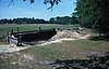 | February 26, 1970 (#70000460) | South of Princeton, off U.S. 701 and SR 1008 35°18′23″N 78°19′26″W / 35.306389°N 78.323889°W / 35.306389; -78.323889 (Bentonville Battleground State Historic Site) | Princeton | |
| 4 | Boyette Slave House |  | September 20, 1979 (#79003329) | Northwest of Kenly on SR 2110 35°39′09″N 78°10′52″W / 35.652589°N 78.181231°W / 35.652589; -78.181231 (Boyette Slave House) | Kenly | |
| 5 | Brooklyn Historic District |  | May 5, 2000 (#00000443) | Roughly bounded by Spring Branch Creek, S. Fifth St., S. Third St., and Lee St. 35°30′22″N 78°20′52″W / 35.506111°N 78.347778°W / 35.506111; -78.347778 (Brooklyn Historic District) | Smithfield | |
| 6 | Clayton Banking Company Building |  | December 6, 1996 (#96001444) | 301 E. Main St. 35°38′59″N 78°27′29″W / 35.649722°N 78.458056°W / 35.649722; -78.458056 (Clayton Banking Company Building) | Clayton | |
| 7 | Clayton Graded School and Clayton Grammar School-Municipal Auditorium |  | October 20, 2001 (#01001133) | 101 and 111 2nd St. 35°39′08″N 78°27′38″W / 35.652222°N 78.460556°W / 35.652222; -78.460556 (Clayton Graded School and Clayton Grammar School-Municipal Auditorium) | Clayton | |
| 8 | Clayton Historic District |  | June 7, 2010 (#10000314) | Bounded by Mulberry St., W Barnes St., Mill St., S Lombard St., Blanche St. 35°39′03″N 78°27′23″W / 35.650711°N 78.456392°W / 35.650711; -78.456392 (Clayton Historic District) | Clayton | |
| 9 | Cleveland School | Upload image | September 7, 2005 (#05000961) | 8968 Cleveland Rd. 35°34′06″N 78°31′43″W / 35.568333°N 78.528611°W / 35.568333; -78.528611 (Cleveland School) | Clayton | |
| 10 | Downtown Selma Historic District | Upload image | August 30, 2010 (#10000601) | Includes portions of both sides of N. and S. Raiford, E. & W. Anderson, E. and W. Waddell, and E. and W. Railroad Sts, and W Web 35°32′12″N 78°17′04″W / 35.536667°N 78.284444°W / 35.536667; -78.284444 (Downtown Selma Historic District) | Selma | |
| 11 | Downtown Smithfield Historic District |  | October 14, 1993 (#93001120) | S. Third and Market Sts. 35°30′39″N 78°20′46″W / 35.510833°N 78.346111°W / 35.510833; -78.346111 (Downtown Smithfield Historic District) | Smithfield | |
| 12 | Noah Edward Edgerton House |  | June 24, 1982 (#82003477) | 301 W. Railroad St. 35°32′10″N 78°17′49″W / 35.536111°N 78.296944°W / 35.536111; -78.296944 (Noah Edward Edgerton House) | Selma | |
| 13 | Ellington-Ellis Farm | Upload image | July 21, 1983 (#83001892) | SR 1004 35°40′18″N 78°28′46″W / 35.671667°N 78.479444°W / 35.671667; -78.479444 (Ellington-Ellis Farm) | Clayton | |
| 14 | Former US Post Office |  | April 22, 1993 (#93000315) | 405 E. Market St. 35°30′38″N 78°20′39″W / 35.510689°N 78.344256°W / 35.510689; -78.344256 (Former US Post Office) | Smithfield | |
| 15 | Four Oaks Commercial Historic District |  | August 9, 2006 (#06000692) | 100-300 blocks N. Main, 100-200 blocks S. Main, 100 block S.W. Railroad, 100 block W Wellons St. & 100 block W. Woodall St. 35°26′46″N 78°25′46″W / 35.446111°N 78.429444°W / 35.446111; -78.429444 (Four Oaks Commercial Historic District) | Four Oaks | |
| 16 | Hannah's Creek Primitive Baptist Church | Upload image | January 25, 1991 (#90002181) | NC 301 southwest of junction with NC 1171 35°24′36″N 78°30′20″W / 35.41°N 78.505556°W / 35.41; -78.505556 (Hannah's Creek Primitive Baptist Church) | Benson | |
| 17 | Harper House | 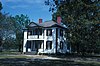 | February 26, 1970 (#70000459) | Near junction of SR 1008 and 1188 35°18′05″N 78°19′57″W / 35.301389°N 78.3325°W / 35.301389; -78.3325 (Harper House) | Harper | |
| 18 | Richard B. Harrison School | Upload image | December 26, 2012 (#12001089) | 605 W. Noble & 405 S. Brevard Sts. 35°32′11″N 78°17′31″W / 35.536426°N 78.291966°W / 35.536426; -78.291966 (Richard B. Harrison School) | Selma | |
| 19 | Hastings-McKinnie House |  | September 8, 1983 (#83001893) | 201 S. Pierce St. 35°27′43″N 78°09′24″W / 35.461944°N 78.156667°W / 35.461944; -78.156667 (Hastings-McKinnie House) | Princeton | |
| 20 | Hood Brothers Building |  | August 14, 1986 (#86001623) | 100-104 S. Third St. 35°30′40″N 78°20′47″W / 35.511128°N 78.346275°W / 35.511128; -78.346275 (Hood Brothers Building) | Smithfield | |
| 21 | Hood-Strickland House |  | August 23, 1990 (#90001310) | 415 S. 4th St. 35°30′22″N 78°20′50″W / 35.50601°N 78.347157°W / 35.50601; -78.347157 (Hood-Strickland House) | Smithfield | |
| 22 | Johnston County Courthouse | 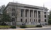 | May 10, 1979 (#79001728) | 207 E. Johnston St. 35°30′41″N 78°20′50″W / 35.511287°N 78.347277°W / 35.511287; -78.347277 (Johnston County Courthouse) | Smithfield | |
| 23 | Walter R. and Eliza Smith Moore House | Upload image | May 4, 2005 (#05000379) | 3919 Raleigh Rd. 35°33′07″N 78°31′43″W / 35.551944°N 78.528611°W / 35.551944; -78.528611 (Walter R. and Eliza Smith Moore House) | Clayton | |
| 24 | North Smithfield Historic District | Upload image | May 26, 2000 (#00000550) | Roughly bounded by Market, Front, North, and Seventh Sts. 35°30′49″N 78°20′38″W / 35.513611°N 78.343889°W / 35.513611; -78.343889 (North Smithfield Historic District) | Smithfield | |
| 25 | Nowell-Mayerburg-Oliver House |  | June 24, 1982 (#82003478) | 312 W. Anderson St. 35°32′14″N 78°17′11″W / 35.537222°N 78.286389°W / 35.537222; -78.286389 (Nowell-Mayerburg-Oliver House) | Selma | |
| 26 | Princeton Graded School | 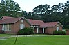 | October 4, 2005 (#05001139) | 601-611 W. Edwards St. 35°28′11″N 78°10′07″W / 35.469753°N 78.168681°W / 35.469753; -78.168681 (Princeton Graded School) | Princeton | |
| 27 | Sanders-Hairr House | Upload image | May 6, 1971 (#71000597) | South of Clayton on SR 1525 35°36′46″N 78°32′05″W / 35.612778°N 78.534722°W / 35.612778; -78.534722 (Sanders-Hairr House) | Clayton | |
| 28 | Shiloh Primitive Baptist Church | Upload image | January 31, 2008 (#07001498) | 9495 Brogden Rd. 35°24′21″N 78°12′41″W / 35.405833°N 78.211389°W / 35.405833; -78.211389 (Shiloh Primitive Baptist Church) | Brogden | |
| 29 | William E. Smith House | 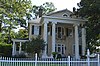 | June 24, 1982 (#82003480) | 309 W. Railroad St. 35°32′08″N 78°17′13″W / 35.535556°N 78.286944°W / 35.535556; -78.286944 (William E. Smith House) | Selma | |
| 30 | Smithfield Masonic Lodge |  | September 28, 2007 (#07001012) | 115 N. Second St. 35°30′45″N 78°20′51″W / 35.51244°N 78.347375°W / 35.51244; -78.347375 (Smithfield Masonic Lodge) | Smithfield | |
| 31 | Stallings-Carpenter House | Upload image | March 28, 1983 (#83001894) | SR 1713 35°41′26″N 78°27′27″W / 35.690556°N 78.4575°W / 35.690556; -78.4575 (Stallings-Carpenter House) | Clayton | |
| 32 | Everitt P. Stevens House | Upload image | June 24, 1982 (#82003481) | SR 1003 35°33′33″N 78°17′49″W / 35.559167°N 78.296944°W / 35.559167; -78.296944 (Everitt P. Stevens House) | Selma | |
| 33 | Union Station |  | June 24, 1982 (#82003482) | E. Railroad St. 35°31′57″N 78°16′50″W / 35.5325°N 78.280556°W / 35.5325; -78.280556 (Union Station) | Selma | |
| 34 | Watson-Sanders House | Upload image | January 26, 2001 (#01000015) | 2810 Brogden Rd. 35°28′07″N 78°19′34″W / 35.468611°N 78.326111°W / 35.468611; -78.326111 (Watson-Sanders House) | Smithfield | |
| 35 | West Selma Historic District |  | December 30, 2011 (#11000975) | Bounded by W. Railroad, N. Brevard, W. Richardson, and N. Pollock Sts. 35°32′20″N 78°17′09″W / 35.538897°N 78.285925°W / 35.538897; -78.285925 (West Selma Historic District) | Selma | |
| 36 | Wood-Rains Cotton Gin | Upload image | December 21, 2023 (#100009629) | 206 W. Railroad Avenue 35°28′00″N 78°09′39″W / 35.4667°N 78.1607°W / 35.4667; -78.1607 (Wood-Rains Cotton Gin) | Princeton |
See also
Wikimedia Commons has media related to National Register of Historic Places in Johnston County, North Carolina.
- National Register of Historic Places listings in North Carolina
- List of National Historic Landmarks in North Carolina
References
- ^ The latitude and longitude information provided in this table was derived originally from the National Register Information System, which has been found to be fairly accurate for about 99% of listings. Some locations in this table may have been corrected to current GPS standards.
- ^ National Park Service, United States Department of the Interior, "National Register of Historic Places: Weekly List Actions", retrieved June 14, 2024.
- ^ Numbers represent an alphabetical ordering by significant words. Various colorings, defined here, differentiate National Historic Landmarks and historic districts from other NRHP buildings, structures, sites or objects.
- ^ "National Register Information System". National Register of Historic Places. National Park Service. April 24, 2008.
- ^ The eight-digit number below each date is the number assigned to each location in the National Register Information System database, which can be viewed by clicking the number.
- v
- t
- e

by county
- Alamance
- Alexander
- Alleghany
- Anson
- Ashe
- Avery
- Beaufort
- Bertie
- Bladen
- Brunswick
- Buncombe
- Burke
- Cabarrus
- Caldwell
- Camden
- Carteret
- Caswell
- Catawba
- Chatham
- Cherokee
- Chowan
- Clay
- Cleveland
- Columbus
- Craven
- Cumberland
- Currituck
- Dare
- Davidson
- Davie
- Duplin
- Durham
- Edgecombe
- Forsyth
- Franklin
- Gaston
- Gates
- Graham
- Granville
- Greene
- Guilford
- Halifax
- Harnett
- Haywood
- Henderson
- Hertford
- Hoke
- Hyde
- Iredell
- Jackson
- Johnston
- Jones
- Lee
- Lenoir
- Lincoln
- Macon
- Madison
- Martin
- McDowell
- Mecklenburg
- Mitchell
- Montgomery
- Moore
- Nash
- New Hanover
- Northampton
- Onslow
- Orange
- Pamlico
- Pasquotank
- Pender
- Perquimans
- Person
- Pitt
- Polk
- Randolph
- Richmond
- Robeson
- Rockingham
- Rowan
- Rutherford
- Sampson
- Scotland
- Stanly
- Stokes
- Surry
- Swain
- Transylvania
- Tyrrell
- Union
- Vance
- Wake
- Warren
- Washington
- Watauga
- Wayne
- Wilkes
- Wilson
- Yadkin
- Yancey
| |
|---|---|
| Topics | |
| Lists by state |
|
| Lists by insular areas | |
| Lists by associated state | |
| Other areas | |
| Related | |
| |


Municipalities and communities of Johnston County, North Carolina, United States | ||
|---|---|---|
County seat: Smithfield | ||
| Towns |  | |
| Unincorporated communities | ||
| Footnotes | ‡This populated place also has portions in an adjacent county or counties | |
| ||


