National Register of Historic Places listings in Pinal County, Arizona
This is a list of the National Register of Historic Places listings in Pinal County, Arizona.
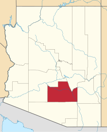
This is intended to be a complete list of the properties and districts on the National Register of Historic Places in Pinal County, Arizona, United States. The locations of National Register properties and districts for which the latitude and longitude coordinates are included below, may be seen in a map.[1]
There are 108 properties and districts listed on the National Register in the county, including two National Monuments and one National Historic Landmark. There are also five former listings.
This National Park Service list is complete through NPS recent listings posted June 14, 2024.[2]
Map all coordinates using OpenStreetMap
Download coordinates as:
- KML
- GPX (all coordinates)
- GPX (primary coordinates)
- GPX (secondary coordinates)
Current listings
| [3] | Name on the Register | Image | Date listed[4] | Location | City or town | Description |
|---|---|---|---|---|---|---|
| 1 | Acadia Ranch |  | February 22, 1984 (#84000765) | 825 E. Mt. Lemmon Highway[5] 32°36′34″N 110°45′54″W / 32.609556°N 110.764955°W / 32.609556; -110.764955 (Acadia Ranch) | Oracle | Now the Acadia Ranch Museum[5] |
| 2 | Adamsville Ruin |  | August 25, 1970 (#70000114) | Address Restricted | Florence | Water tanks which once served Adamsville. |
| 3 | All Saints' Church |  | May 3, 1984 (#84000768) | 705 E. American Avenue[6] 32°36′35″N 110°45′59″W / 32.609786°N 110.766516°W / 32.609786; -110.766516 (All Saints' Church) | Oracle | |
| 4 | American Flag Post Office Ranch | 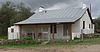 | June 20, 1979 (#79000426) | 5 miles southeast of Oracle 32°34′48″N 110°43′14″W / 32.580066°N 110.72054°W / 32.580066; -110.72054 (American Flag Post Office Ranch) | Oracle | Oldest surviving territorial post office building in Arizona. |
| 5 | Ramon Arballo House |  | August 1, 1986 (#86002623) | 515 Park St.[7] 33°02′12″N 111°22′59″W / 33.036593°N 111.38308°W / 33.036593; -111.38308 (Ramon Arballo House) | Florence | |
| 6 | Encarnacion Avenenti House |  | July 13, 1987 (#87001592) | 203 Butte St. 33°01′52″N 111°23′07″W / 33.031111°N 111.385278°W / 33.031111; -111.385278 (Encarnacion Avenenti House) | Florence | Demolished |
| 7 | Earl Bayless House |  | April 16, 1985 (#85000878) | 211 N. Cameron 32°52′31″N 111°44′52″W / 32.875392°N 111.747851°W / 32.875392; -111.747851 (Earl Bayless House) | Casa Grande | |
| 8 | Wilbur O. Bayless/Grasty House |  | April 16, 1985 (#85000879) | 221 N. Cameron 32°52′32″N 111°44′52″W / 32.875582°N 111.74785°W / 32.875582; -111.74785 (Wilbur O. Bayless/Grasty House) | Casa Grande | Listed erroneously in NRHP as "Wilbur O. Baylis/Grasty House".[8] |
| 9 | Bien/McNatt House |  | April 16, 1985 (#85000880) | 208A W. 1st St. 32°52′38″N 111°45′19″W / 32.877348°N 111.755404°W / 32.877348; -111.755404 (Bien/McNatt House) | Casa Grande | |
| 10 | Dr. George M. and Esther A. Brockway House |  | May 26, 2004 (#04000485) | 501 S. Central Ave. 33°01′43″N 111°23′25″W / 33.028611°N 111.390278°W / 33.028611; -111.390278 (Dr. George M. and Esther A. Brockway House) | Florence | |
| 11 | Building at 121 North Florence Street |  | November 20, 2002 (#02000737) | 121 N. Florence St. 32°52′35″N 111°45′16″W / 32.876346°N 111.754496°W / 32.876346; -111.754496 (Building at 121 North Florence Street) | Casa Grande | |
| 12 | Building at 400 East Third Street |  | November 20, 2002 (#02000749) | 400 E. 3rd St. 32°52′36″N 111°45′00″W / 32.876566°N 111.750041°W / 32.876566; -111.750041 (Building at 400 East Third Street) | Casa Grande | |
| 13 | Butte-Cochran Charcoal Ovens | Upload image | May 30, 1975 (#75000358) | 16 miles east of Florence north of Gila River 33°06′16″N 111°09′52″W / 33.104444°N 111.164444°W / 33.104444; -111.164444 (Butte-Cochran Charcoal Ovens) | Florence | |
| 14 | Chi'chil Bildagoteel Historic District |  | March 4, 2016 (#16000002) | Including and surrounding the Oak Flat campground[9] 33°18′29″N 111°03′00″W / 33.308056°N 111.050000°W / 33.308056; -111.050000 (Chi'chil Bildagoteel Historic District) | Superior | |
| 15 | Camp Grant Massacre Site | Upload image | March 6, 1998 (#98000171) | Address Restricted | Mammoth | |
| 16 | Carminatti-Perham House |  | August 1, 1986 (#86002624) | 6th and Florence Sts. 33°02′08″N 111°23′01″W / 33.035594°N 111.383628°W / 33.035594; -111.383628 (Carminatti-Perham House) | Florence | |
| 17 | Casa Grande Dispatch |  | November 20, 2002 (#02000747) | 109 E. 2nd St. 32°52′37″N 111°45′12″W / 32.876837°N 111.753387°W / 32.876837; -111.753387 (Casa Grande Dispatch) | Casa Grande | |
| 18 | Casa Grande Hospital |  | November 20, 2002 (#02000740) | 601 N. Cameron Ave. 32°52′44″N 111°44′52″W / 32.878817°N 111.747845°W / 32.878817; -111.747845 (Casa Grande Hospital) | Casa Grande | |
| 19 | Casa Grande Hotel |  | April 16, 1985 (#85000881) | 201 W. Main Ave. 32°52′33″N 111°45′23″W / 32.875754°N 111.756275°W / 32.875754; -111.756275 (Casa Grande Hotel) | Casa Grande | |
| 20 | Casa Grande National Monument |  | October 15, 1966 (#66000192) | Casa Grande National Monument 32°59′49″N 111°31′55″W / 32.996944°N 111.531944°W / 32.996944; -111.531944 (Casa Grande National Monument) | Coolidge | |
| 21 | Casa Grande Stone Church |  | June 15, 1978 (#78000567) | 110 W. Florence Boulevard[10] 32°52′47″N 111°45′15″W / 32.879788°N 111.754285°W / 32.879788; -111.754285 (Casa Grande Stone Church) | Casa Grande | Now the Casa Grande Valley Historical Society museum[10] |
| 22 | Casa Grande Union High School and Gymnasium |  | February 3, 1986 (#86000821) | 510 E. Florence Boulevard[10] 32°52′49″N 111°44′51″W / 32.880276°N 111.747625°W / 32.880276; -111.747625 (Casa Grande Union High School and Gymnasium) | Casa Grande | Now Casa Grande's city hall.[10] |
| 23 | Casa Grande Woman's Club Building |  | March 21, 1979 (#79000425) | 407 N. Sacaton St. 32°52′46″N 111°45′18″W / 32.87933°N 111.754888°W / 32.87933; -111.754888 (Casa Grande Woman's Club Building) | Casa Grande | |
| 24 | Central Creditors Association Building |  | April 16, 1985 (#85000882) | 118 N. Sacaton 32°52′38″N 111°45′21″W / 32.877215°N 111.755886°W / 32.877215; -111.755886 (Central Creditors Association Building) | Casa Grande | |
| 25 | Church of the Nazarene |  | November 20, 2002 (#02000750) | 305 E. 4th St. 32°52′39″N 111°45′03″W / 32.877461°N 111.750707°W / 32.877461; -111.750707 (Church of the Nazarene) | Casa Grande | |
| 26 | Albert Colton and H. H. Freeman House |  | August 1, 1986 (#86002625) | Willow Street and Butte Avenue, southwest corner 33°01′52″N 111°23′23″W / 33.031063°N 111.389689°W / 33.031063; -111.389689 (Albert Colton and H. H. Freeman House) | Florence | |
| 27 | Coolidge Dam |  | October 29, 1981 (#81000135) | Southwest of San Carlos 33°10′26″N 110°31′37″W / 33.173889°N 110.526944°W / 33.173889; -110.526944 (Coolidge Dam) | San Carlos | (ed. note: does this span 2 counties, should appear in other county list too) |
| 28 | Coolidge Woman's Club | 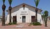 | October 4, 1990 (#90001524) | 240 W. Pinkley Ave. 32°58′44″N 111°31′07″W / 32.979011°N 111.51874°W / 32.979011; -111.51874 (Coolidge Woman's Club) | Coolidge | |
| 29 | William Cox Building |  | September 3, 1999 (#99001068) | 501 N. Marshall St. 32°52′43″N 111°45′06″W / 32.878495°N 111.751672°W / 32.878495; -111.751672 (William Cox Building) | Casa Grande | |
| 30 | Cruz Trading Post |  | April 16, 1985 (#85000883) | 200 W. Main St. 32°52′35″N 111°45′20″W / 32.87643°N 111.75564°W / 32.87643; -111.75564 (Cruz Trading Post) | Casa Grande | Commercial building built around 1888, renovated in Pueblo Revival style around 1937. |
| 31 | Judge William T. Day House |  | July 25, 1985 (#85001624) | 306 W. 1st St.[10] 32°52′40″N 111°45′22″W / 32.877862°N 111.756208°W / 32.877862; -111.756208 (Judge William T. Day House) | Casa Grande | |
| 32 | Devil's Canyon Bridge |  | September 30, 1988 (#88001681) | Abandoned U.S. Route 60 over Devil's Canyon 33°19′40″N 111°01′56″W / 33.32791°N 111.03209°W / 33.32791; -111.03209 (Devil's Canyon Bridge) | Superior | Filled spandrel arch bridge |
| 33 | James S. Melquides E. Douglass House |  | May 27, 2004 (#04000486) | 850 S. Park St. 33°01′27″N 111°23′00″W / 33.024063°N 111.383453°W / 33.024063; -111.383453 (James S. Melquides E. Douglass House) | Florence | |
| 34 | Evergreen Addition Historic District |  | January 22, 2009 (#08001346) | Generally bounded by McMurray Blvd., Gilbert Ave., Florence Blvd., and Casa Grande Ave. 32°52′59″N 111°44′43″W / 32.883125°N 111.745369°W / 32.883125; -111.745369 (Evergreen Addition Historic District) | Casa Grande | |
| 35 | First Baptist Church |  | November 20, 2002 (#02000751) | 218 E. 8th St. 32°52′51″N 111°45′04″W / 32.88088°N 111.751213°W / 32.88088; -111.751213 (First Baptist Church) | Casa Grande | |
| 36 | First Florence Courthouse |  | July 30, 1974 (#74000461) | 5th and Main Sts. 33°02′32″N 111°23′40″W / 33.042222°N 111.394444°W / 33.042222; -111.394444 (First Florence Courthouse) | Florence | 1878 courthouse, now preserved within McFarland State Historic Park. |
| 37 | First Presbyterian Church of Florence |  | June 10, 1994 (#94000573) | 225 E. Butte Ave. 33°01′52″N 111°23′06″W / 33.030998°N 111.385049°W / 33.030998; -111.385049 (First Presbyterian Church of Florence) | Florence | |
| 38 | Florence Townsite Historic District |  | October 26, 1982 (#82001623) | Roughly bounded by 3rd and Florence Sts., Butte and Central Aves., and Chase/Ruggles Ditch 33°02′01″N 111°23′13″W / 33.033611°N 111.386944°W / 33.033611; -111.386944 (Florence Townsite Historic District) | Florence | Main Street |
| 39 | Florence Union High School |  | June 22, 1987 (#87001306) | 1000 S. Main St. 33°01′21″N 111°23′16″W / 33.0225°N 111.387778°W / 33.0225; -111.387778 (Florence Union High School) | Florence | |
| 40 | Thomas Fulbright House |  | October 4, 1996 (#96001055) | 75 S. Matilda St. 33°01′50″N 111°23′02″W / 33.030647°N 111.383933°W / 33.030647; -111.383933 (Thomas Fulbright House) | Florence | |
| 41 | Grewe Site | Upload image | May 30, 2001 (#01000565) | Address Restricted | Coolidge | |
| 42 | Ha-ak Va-ak Intaglio Site | Upload image | September 6, 1979 (#79000427) | Address Restricted | Sacaton | |
| 43 | Harvey-Niemeyer House |  | August 1, 1986 (#86002627) | 250 S. Main St. 33°01′45″N 111°23′13″W / 33.029167°N 111.386944°W / 33.029167; -111.386944 (Harvey-Niemeyer House) | Florence | Address was 1613 Main St. |
| 44 | C. D. Henry House |  | August 1, 1986 (#86002628) | 144 S. Willow St. 33°01′49″N 111°23′20″W / 33.030278°N 111.388889°W / 33.030278; -111.388889 (C. D. Henry House) | Florence | Address was 1520 Willow St. |
| 45 | Hieroglyphic Canyon Site |  | April 11, 1994 (#94000269) | Address Restricted | Apache Junction | |
| 46 | Hohokam-Pima National Monument |  | July 19, 1974 (#74002221) | 20 miles (30 km) south of Phoenix on Interstate 10 33°11′12″N 111°55′00″W / 33.186667°N 111.916667°W / 33.186667; -111.916667 (Hohokam-Pima National Monument) | Gila River Indian Reservation | |
| 47 | House at 222 West Ninth St. |  | November 20, 2002 (#02000743) | 222 W. 9th St. 32°52′55″N 111°45′21″W / 32.881895°N 111.755823°W / 32.881895; -111.755823 (House at 222 West Ninth St.) | Casa Grande | |
| 48 | House at 317 East Eighth Street |  | November 20, 2002 (#02000753) | 317 E. 8th St. 32°52′49″N 111°45′00″W / 32.880342°N 111.749926°W / 32.880342; -111.749926 (House at 317 East Eighth Street) | Casa Grande | |
| 49 | House at 320 West Eighth Street |  | November 20, 2002 (#02000745) | 320 W. 8th St. 32°52′51″N 111°45′26″W / 32.880778°N 111.757101°W / 32.880778; -111.757101 (House at 320 West Eighth Street) | Casa Grande | |
| 50 | House at 323 West Eighth St. | 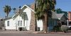 | November 20, 2002 (#02000744) | 323 W. 8th St. 32°52′49″N 111°45′26″W / 32.880317°N 111.757101°W / 32.880317; -111.757101 (House at 323 West Eighth St.) | Casa Grande | |
| 51 | House at 59 North Brown Avenue |  | November 20, 2002 (#02000742) | 59 N. Brown Ave. 32°52′21″N 111°44′44″W / 32.872547°N 111.745575°W / 32.872547; -111.745575 (House at 59 North Brown Avenue) | Casa Grande | |
| 52 | House at 736 North Center Avenue |  | November 20, 2002 (#02000738) | 736 N. Center Ave. 32°52′49″N 111°45′11″W / 32.880274°N 111.753159°W / 32.880274; -111.753159 (House at 736 North Center Avenue) | Casa Grande | |
| 53 | House at North Lehmberg Avenue |  | November 20, 2002 (#02000735) | 1105 N. Lehmberg Ave. 32°53′08″N 111°44′37″W / 32.885531°N 111.743516°W / 32.885531; -111.743516 (House at North Lehmberg Avenue) | Casa Grande | |
| 54 | Dr. George Huffman House |  | August 1, 1986 (#86002629) | 471 E. Butte Avenue[11] 33°01′52″N 111°22′58″W / 33.03098°N 111.382836°W / 33.03098; -111.382836 (Dr. George Huffman House) | Florence | |
| 55 | Johnson's Grocery Store |  | April 16, 1985 (#85000885) | 301 N. Picacho 32°52′36″N 111°45′05″W / 32.876756°N 111.751281°W / 32.876756; -111.751281 (Johnson's Grocery Store) | Casa Grande | |
| 56 | Kannally Ranch |  | March 28, 1996 (#96000307) | Mt. Lemmon Highway east of Oracle 32°36′34″N 110°43′59″W / 32.609444°N 110.733056°W / 32.609444; -110.733056 (Kannally Ranch) | Oracle | |
| 57 | Kelvin Bridge |  | September 30, 1988 (#88001646) | Florence-Kelvin Highway over the Gila River 33°06′10″N 110°58′26″W / 33.102778°N 110.973889°W / 33.102778; -110.973889 (Kelvin Bridge) | Kelvin | |
| 58 | V.W. Kilcrease Building |  | November 20, 2002 (#02000754) | 139 W. 1st St. 32°52′36″N 111°45′18″W / 32.876744°N 111.755127°W / 32.876744; -111.755127 (V.W. Kilcrease Building) | Casa Grande | |
| 59 | Henry and Anna Kochsmeier House |  | November 20, 2002 (#02000746) | 403 W. 2nd Ave. 32°52′33″N 111°45′34″W / 32.875762°N 111.759547°W / 32.875762; -111.759547 (Henry and Anna Kochsmeier House) | Casa Grande | |
| 60 | Gus Kratzka House |  | April 16, 1985 (#85000886) | 319 W. 3rd Street[10] 32°52′45″N 111°45′20″W / 32.879112°N 111.755677°W / 32.879112; -111.755677 (Gus Kratzka House) | Casa Grande | Now the Casa Grande Art Museum[10] |
| 61 | La Casa del High Jinks |  | October 16, 1996 (#96001056) | High Jinks Rd., 8 miles southeast of Oracle and 2.5 miles west of Mt. Lemmon Rd. 32°34′17″N 110°44′18″W / 32.571311°N 110.738429°W / 32.571311; -110.738429 (La Casa del High Jinks) | Oracle | |
| 62 | Laundry Building |  | April 16, 1985 (#85000887) | Rear of 309 W. 8th 32°52′49″N 111°45′22″W / 32.880278°N 111.756111°W / 32.880278; -111.756111 (Laundry Building) | Casa Grande | Apparently no longer extant[12] |
| 63 | Dr. H. B. Lehmberg House |  | April 16, 1985 (#85000888) | 929 N. Lehmberg 32°52′59″N 111°44′37″W / 32.882979°N 111.743582°W / 32.882979; -111.743582 (Dr. H. B. Lehmberg House) | Casa Grande | |
| 64 | Lincoln Hospital |  | November 20, 2002 (#02000741) | 112 N. Brown Ave. 32°52′27″N 111°44′41″W / 32.87419°N 111.744642°W / 32.87419; -111.744642 (Lincoln Hospital) | Casa Grande | |
| 65 | Inez and Davis Littlefield Bea House |  | August 1, 1986 (#86002630) | 1913 Elizabeth St. 33°01′38″N 111°23′08″W / 33.027222°N 111.385556°W / 33.027222; -111.385556 (Inez and Davis Littlefield Bea House) | Florence | |
| 66 | Andronico Lorona Second House |  | August 1, 1986 (#86002631) | 324 Silver St.[13] 33°02′05″N 111°22′54″W / 33.034789°N 111.38156°W / 33.034789; -111.38156 (Andronico Lorona Second House) | Florence | |
| 67 | Los Robles Archeological District | Upload image | May 11, 1989 (#89000337) | Address Restricted | Red Rock | |
| 68 | Magma Hotel |  | August 19, 1994 (#94000981) | 100-130 Main St. 33°17′38″N 111°05′45″W / 33.293889°N 111.095833°W / 33.293889; -111.095833 (Magma Hotel) | Superior | The original Magma Hotel was built in 1912 and is located at 100 Main Street. An adobe addition was built in 1916. In 1923, a two story brick addition labelled "MacPherson's Hotel Magma" (pictured) was built at 130 Main Street. |
| 69 | Mandell and Meyer Building | 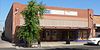 | November 20, 2002 (#02000736) | 211 N. Florence St. 32°52′37″N 111°45′15″W / 32.876979°N 111.754124°W / 32.876979; -111.754124 (Mandell and Meyer Building) | Casa Grande | |
| 70 | Manjarres House |  | August 6, 1987 (#87001591) | 351 Silver St.[14] 33°02′05″N 111°22′53″W / 33.034785°N 111.381251°W / 33.034785; -111.381251 (Manjarres House) | Florence | |
| 71 | McClellan Wash Archeological District | Upload image | May 11, 1989 (#89000336) | Address Restricted | Picacho | |
| 72 | James and Mary McGee House | Upload image | May 27, 2004 (#04000487) | 330 E. Butte Ave. 33°01′54″N 111°22′58″W / 33.031667°N 111.382778°W / 33.031667; -111.382778 (James and Mary McGee House) | Florence | Demolished |
| 73 | Meehan/Gaar House |  | April 16, 1985 (#85000890) | 200 W. 1st St.[10] 32°52′38″N 111°45′19″W / 32.877177°N 111.755147°W / 32.877177; -111.755147 (Meehan/Gaar House) | Casa Grande | |
| 74 | Mineral Creek Bridge | Upload image | September 30, 1988 (#88001648) | Old U.S. Route 77 over Mineral Creek 33°07′20″N 110°58′32″W / 33.122222°N 110.975556°W / 33.122222; -110.975556 (Mineral Creek Bridge) | Kelvin | |
| 75 | Paramount Theatre |  | September 3, 1999 (#99001067) | 420 N. Florence St. 32°52′42″N 111°45′09″W / 32.878325°N 111.752621°W / 32.878325; -111.752621 (Paramount Theatre) | Casa Grande | |
| 76 | Period Revival House |  | July 25, 1985 (#85001623) | 905 N. Lehmberg 32°52′55″N 111°44′37″W / 32.881975°N 111.743531°W / 32.881975; -111.743531 (Period Revival House) | Casa Grande | |
| 77 | Picacho Pass Skirmish Site-Overland Mail Co. Stage Station at Picacho Pass |  | November 22, 2002 (#02001384) | 1 mile northwest of Interchange #219 on Interstate 10 32°40′10″N 111°24′53″W / 32.669444°N 111.414722°W / 32.669444; -111.414722 (Picacho Pass Skirmish Site-Overland Mail Co. Stage Station at Picacho Pass) | Picacho | The site is near Picacho Peak State Park where a reenactment takes place. |
| 78 | Adrian Pierson House |  | July 13, 1987 (#87001593) | E. 6th St. and U.S. Route 79 33°02′08″N 111°22′42″W / 33.035556°N 111.378333°W / 33.035556; -111.378333 (Adrian Pierson House) | Florence | |
| 79 | Second Pinal County Courthouse | 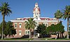 | August 2, 1978 (#78000568) | Pinal and 12th Sts. 33°01′56″N 111°23′06″W / 33.032222°N 111.385°W / 33.032222; -111.385 (Second Pinal County Courthouse) | Florence | |
| 80 | Pioneer Market |  | April 16, 1985 (#85000919) | 119 N. Florence St.[10] 32°52′35″N 111°45′16″W / 32.876279°N 111.754567°W / 32.876279; -111.754567 (Pioneer Market) | Casa Grande | |
| 81 | Prettyman's Meat Market and Grocery/Brigg's Jeweler |  | April 16, 1985 (#85000891) | 110 W. Main St.[10] 32°52′34″N 111°45′18″W / 32.876069°N 111.754948°W / 32.876069; -111.754948 (Prettyman's Meat Market and Grocery/Brigg's Jeweler) | Casa Grande | |
| 82 | W. Y. Price House |  | August 1, 1986 (#86002632) | 1612 Willow St. 33°01′48″N 111°23′20″W / 33.03°N 111.388889°W / 33.03; -111.388889 (W. Y. Price House) | Florence | |
| 83 | Queen Creek Bridge |  | September 30, 1988 (#88001679) | Abandoned U.S. Route 60 over Upper Queen Creek Canyon 33°17′47″N 111°05′19″W / 33.296389°N 111.088611°W / 33.296389; -111.088611 (Queen Creek Bridge) | Superior | |
| 84 | Queen Creek Bridge |  | September 30, 1988 (#88001643) | Old Florence Highway over Queen Creek 33°17′16″N 111°19′42″W / 33.287778°N 111.328333°W / 33.287778; -111.328333 (Queen Creek Bridge) | Florence Junction | |
| 85 | Rancho Linda Vista |  | September 9, 1999 (#99001099) | 1955 W. Linda Vista Rd. 32°36′12″N 110°47′41″W / 32.603333°N 110.794722°W / 32.603333; -110.794722 (Rancho Linda Vista) | Oracle | |
| 86 | Rancho Solano | Upload image | September 7, 1995 (#95001079) | 34145 S. Golder Dam Rd. 32°34′01″N 110°50′52″W / 32.566944°N 110.847778°W / 32.566944; -110.847778 (Rancho Solano) | Catalina | |
| 87 | Randolph Community Historic District | Upload image | March 18, 2024 (#100010053) | Generally bounded by Highway 287, East Randolph Rd., East Kleck Rd., and Union Pacific Railroad Right-of-Way 32°54′57″N 111°30′50″W / 32.9158°N 111.5138°W / 32.9158; -111.5138 (Randolph Community Historic District) | Coolidge | |
| 88 | S.S. Blinky Jr. Building |  | November 20, 2002 (#02000748) | 465 W. Gila Bend Highway[10] 32°52′47″N 111°45′31″W / 32.879647°N 111.758742°W / 32.879647; -111.758742 (S.S. Blinky Jr. Building) | Casa Grande | |
| 89 | Sacaton Dam Bridge |  | September 30, 1988 (#88001621) | Gila River Indian Reservation Rd. 33°05′19″N 111°41′11″W / 33.088611°N 111.686389°W / 33.088611; -111.686389 (Sacaton Dam Bridge) | Sacaton | |
| 90 | Saint Anthony's Church and Rectory |  | April 16, 1985 (#85000892) | 215 N. Picacho 32°52′33″N 111°45′09″W / 32.87578°N 111.752549°W / 32.87578; -111.752549 (Saint Anthony's Church and Rectory) | Casa Grande | |
| 91 | San Tan Canal Bridge |  | September 30, 1988 (#88001622) | Gila River Indian Reservation Rd. 33°05′30″N 111°41′11″W / 33.091667°N 111.686389°W / 33.091667; -111.686389 (San Tan Canal Bridge) | Sacaton | |
| 92 | Shonessy Building/Don Chun Wo Store |  | April 16, 1985 (#85000893) | 121 W. Main Ave. 32°52′32″N 111°45′19″W / 32.875556°N 111.755278°W / 32.875556; -111.755278 (Shonessy Building/Don Chun Wo Store) | Casa Grande | Apparently no longer extant.[15] |
| 93 | Shonessy House |  | April 16, 1985 (#85000894) | 115 W. Main Ave. 32°52′32″N 111°45′22″W / 32.875514°N 111.756004°W / 32.875514; -111.756004 (Shonessy House) | Casa Grande | |
| 94 | Snaketown National Historic Landmark | | October 15, 1966 (#07001462) | Chandler vicinity 33°10′59″N 111°55′28″W / 33.183056°N 111.9245°W / 33.183056; -111.9245 (Snaketown National Historic Landmark) | Chandler | |
| 95 | Stone Bungalow |  | April 16, 1985 (#85000895) | 515 E. 3rd St. 32°52′32″N 111°44′57″W / 32.875578°N 111.749261°W / 32.875578; -111.749261 (Stone Bungalow) | Casa Grande | |
| 96 | Stone Warehouse |  | April 16, 1985 (#85000896) | 119 Florence St. in rear 32°52′35″N 111°45′17″W / 32.876395°N 111.754786°W / 32.876395; -111.754786 (Stone Warehouse) | Casa Grande | |
| 97 | Benjamin Templeton House |  | November 20, 2002 (#02000739) | 923 N. Center Ave. 32°52′57″N 111°45′14″W / 32.882521°N 111.75381°W / 32.882521; -111.75381 (Benjamin Templeton House) | Casa Grande | |
| 98 | Boyce Thompson Southwestern Arboretum |  | March 26, 1976 (#76000381) | 2 miles west of Superior on U.S. Route 60 33°16′21″N 111°09′27″W / 33.2725°N 111.1575°W / 33.2725; -111.1575 (Boyce Thompson Southwestern Arboretum) | Superior | |
| 99 | Truman-Randall House |  | July 13, 1987 (#87001594) | 550 S. Main St. 33°01′37″N 111°23′14″W / 33.026944°N 111.387222°W / 33.026944; -111.387222 (Truman-Randall House) | Florence | Address was 2010 S. Main St. |
| 100 | Valley National Bank |  | November 20, 2002 (#02000733) | 221 N. Florence St. 32°52′38″N 111°45′14″W / 32.877112°N 111.754011°W / 32.877112; -111.754011 (Valley National Bank) | Casa Grande | |
| 101 | Vasquez House | 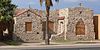 | April 16, 1985 (#85000897) | 114 E. Florence Boulevard 32°52′47″N 111°45′09″W / 32.879797°N 111.7526°W / 32.879797; -111.7526 (Vasquez House) | Casa Grande | |
| 102 | Verdugo Homestead Historic District | Upload image | August 30, 2001 (#01000904) | Address Restricted | Randolph | |
| 103 | Ward's Variety Store | 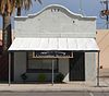 | April 16, 1985 (#85000898) | 112 N. Sacaton 32°52′38″N 111°45′22″W / 32.877085°N 111.755977°W / 32.877085; -111.755977 (Ward's Variety Store) | Casa Grande | |
| 104 | P. C. Warner First House | Upload image | August 1, 1986 (#86002633) | 310 3rd St. 33°02′13″N 111°23′05″W / 33.036944°N 111.384722°W / 33.036944; -111.384722 (P. C. Warner First House) | Florence | Demolished |
| 105 | White House |  | April 16, 1985 (#85000899) | 901 N. Morrison 32°52′54″N 111°44′48″W / 32.881761°N 111.746774°W / 32.881761; -111.746774 (White House) | Casa Grande | |
| 106 | Walter Wilbur House |  | November 20, 2002 (#02000752) | 904 E. 8th St. 32°52′51″N 111°44′35″W / 32.880739°N 111.742933°W / 32.880739; -111.742933 (Walter Wilbur House) | Casa Grande | |
| 107 | C. J. (Blinky) Wilson House |  | April 16, 1985 (#85000900) | 223 W. 10th 32°52′57″N 111°45′21″W / 32.882476°N 111.755804°W / 32.882476; -111.755804 (C. J. (Blinky) Wilson House) | Casa Grande | |
| 108 | Winkelman Bridge |  | September 30, 1988 (#88001649) | Old State Route 77 over the Gila River 32°59′05″N 110°46′20″W / 32.984598°N 110.77231°W / 32.984598; -110.77231 (Winkelman Bridge) | Winkelman |
Former listings
| [3] | Name on the Register | Image | Date listed | Date removed | Location | City or town | Description |
|---|---|---|---|---|---|---|---|
| 1 | C.H. Cook Memorial Church |  | August 28, 1975 (#75000359) | May 13, 2019 | Church St. 33°04′44″N 111°44′28″W / 33.078889°N 111.741111°W / 33.078889; -111.741111 (C.H. Cook Memorial Church) | Sacaton | Destroyed by fire March 2019 |
| 2 | Ed and Lottie Devine House | Upload image | August 1, 1986 (#86002626) | December 6, 1996 | 1200 Central St. 32°59′06″N 110°46′18″W / 32.985°N 110.771667°W / 32.985; -110.771667 (Ed and Lottie Devine House) | Winkelman | |
| 3 | Fisher Memorial Home |  | April 16, 1985 (#85000884) | January 31, 2019 | 300 E. 8th St. 32°52′51″N 111°45′03″W / 32.880867°N 111.750741°W / 32.880867; -111.750741 (Fisher Memorial Home) | Casa Grande | Destroyed by fire in April 2017[16] |
| 4 | John C. Loss House | Upload image | April 16, 1985 (#85000889) | October 2, 1992 | 107 W. Main Ave. | Casa Grande | |
| 5 | Southern Pacific Railroad Depot |  | November 20, 2002 (#02000734) | January 31, 2019 | 201 W. Main St. 32°52′34″N 111°45′19″W / 32.876111°N 111.755278°W / 32.876111; -111.755278 (Southern Pacific Railroad Depot) | Casa Grande | Depot was destroyed by fire in 2009.[17] |
See also
Wikimedia Commons has media related to National Register of Historic Places in Pinal County, Arizona.
- List of National Historic Landmarks in Arizona
- National Register of Historic Places listings in Arizona
References
- ^ The latitude and longitude information provided in this table was derived originally from the National Register Information System, which has been found to be fairly accurate for about 99% of listings. Some locations in this table may have been corrected to current GPS standards.
- ^ National Park Service, United States Department of the Interior, "National Register of Historic Places: Weekly List Actions", retrieved June 14, 2024.
- ^ a b Numbers represent an alphabetical ordering by significant words. Various colorings, defined here, differentiate National Historic Landmarks and historic districts from other NRHP buildings, structures, sites or objects.
- ^ The eight-digit number below each date is the number assigned to each location in the National Register Information System database, which can be viewed by clicking the number.
- ^ a b "Acadia Ranch Museum". Oracle Historical Society. Retrieved 2013-09-14.
- ^ Untitled page regarding church's winning 2008 Firewise award. Oracle Fire Department. Retrieved 2013-09-11.
- ^ See 2013 photo of address plaque.
- ^ At NRHP Focus, the name is given as "Baylis"."Arizona State Historic Property Inventory: Wilbur 0. Bayless/Grasty House", linked from Focus, spells the name "Bayless". It is also spelled "Bayless" at "Main Street District Historic Sites", maintained by Casa Grande Main Street.
- ^ Bregel, Emily. Historic Designation of Mining Site Provokes Lawmakers' Anger. Arizona Daily Star, 2016-03-14. Accessed 2016-05-13.
- ^ a b c d e f g h i j k "Main Street District Historic Sites". Casa Grande Main Street. Retrieved 2013-09-06.
- ^ House number is visible on gate in this 2013 photo
- ^ See photo of vacant lot at southwest corner of 8th Street and Arbor Avenue. As of September 2013, site was not listed at "Main Street District Historic Sites", Casa Grande Mainstreet.
- ^ Address is visible near right edge of this 2013 photo.
- ^ Address "351" is visible on the door in this 2013 photo.
- ^ See 2013 photo of 100s block of West Main Ave, which shows nothing on the block apart from the Shonessy house. The site is not listed at Casa Grande Mainstreet's "Main Street District Historic Sites" page, retrieved 2013-09-08.
- ^ "Historic CG building that burned was once a beautiful home". Casa Grande Dispatch. April 17, 2017. Retrieved May 3, 2022.
- ^ "Fire destroys historic Casa Grande train depot". The Arizona Daily Sun. June 7, 2009. p. A2. Retrieved May 3, 2022 – via Newspapers.com.
- v
- t
- e
Municipalities and communities of Pinal County, Arizona, United States
County seat: Florence

- Ak-Chin Village
- Arizona City
- Blackwater
- Cactus Forest
- Campo Bonito
- Casa Blanca
- Chuichu
- Dudleyville
- Gold Canyon
- Goodyear Village
- Kohatk
- Lower Santan Village
- Oracle
- Picacho
- Queen Valley
- Red Rock
- Sacate Village
- Sacaton
- Sacaton Flats Village
- Saddlebrooke
- San Manuel
- San Tan Valley
- Santa Cruz
- Stanfield
- Stotonic Village
- Sweet Water Village
- Tat Momoli
- Top-of-the-World‡
- Upper Santan Village
- Vaiva Vo
- Wet Camp Village
places
‡This populated place also has portions in an adjacent county or counties
- Arizona portal
- United States portal


