National Register of Historic Places listings in Walworth County, South Dakota

This is a list of the National Register of Historic Places listings in Walworth County, South Dakota.
This is intended to be a complete list of the properties on the National Register of Historic Places in Walworth County, South Dakota, United States. The locations of National Register properties for which the latitude and longitude coordinates are included below, may be seen in a map.[1]
There are 13 properties listed on the National Register in the county.
This National Park Service list is complete through NPS recent listings posted June 7, 2024.[2]
Map all coordinates using OpenStreetMap
Download coordinates as:
- KML
- GPX (all coordinates)
- GPX (primary coordinates)
- GPX (secondary coordinates)
Current listings
| [3] | Name on the Register[4] | Image | Date listed[5] | Location | City or town | Description |
|---|---|---|---|---|---|---|
| 1 | Brown Palace Hotel | 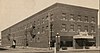 | January 27, 1983 (#83003022) | 301 Main St. 45°32′08″N 100°26′02″W / 45.535556°N 100.433889°W / 45.535556; -100.433889 (Brown Palace Hotel) | Mobridge | |
| 2 | A. H. Brown Public Library |  | December 22, 1978 (#78002573) | N. Main St. 45°32′17″N 100°26′02″W / 45.538056°N 100.433889°W / 45.538056; -100.433889 (A. H. Brown Public Library) | Mobridge | |
| 3 | Brown-Evans House | Upload image | June 21, 1990 (#90000960) | 405 1st Ave., W. 45°32′12″N 100°26′07″W / 45.536667°N 100.435278°W / 45.536667; -100.435278 (Brown-Evans House) | Mobridge | |
| 4 | Gravel Pit Site (39WW203) |  | April 3, 1986 (#86000834) | Address Restricted | Mobridge | |
| 5 | Java Depot | Upload image | June 6, 2001 (#01000640) | Northwestern corner of Railway Ave. and Main St. 45°30′17″N 99°53′12″W / 45.504722°N 99.886667°W / 45.504722; -99.886667 (Java Depot) | Java | |
| 6 | Johnson Barn | Upload image | August 30, 2005 (#05000950) | Approximately 4 miles west-northwest of Glenham 45°32′55″N 100°21′36″W / 45.548611°N 100.36°W / 45.548611; -100.36 (Johnson Barn) | Mobridge | |
| 7 | Mobridge Auditorium | 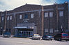 | May 23, 1986 (#86001189) | 212 Main St. 45°32′10″N 100°25′58″W / 45.536111°N 100.432778°W / 45.536111; -100.432778 (Mobridge Auditorium) | Mobridge | |
| 8 | Mobridge Masonic Temple | 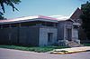 | March 25, 1977 (#77001259) | 6th and Main Sts. 45°32′17″N 100°26′00″W / 45.538056°N 100.433333°W / 45.538056; -100.433333 (Mobridge Masonic Temple) | Mobridge | |
| 9 | Molstad Lake Park | Upload image | November 29, 2010 (#10000953) | 1¾ miles north of U.S. Route 12 on 293rd Ave. 45°33′38″N 100°18′20″W / 45.560556°N 100.305556°W / 45.560556; -100.305556 (Molstad Lake Park) | Glenham | |
| 10 | Wilhelm Moser House-Barn | Upload image | November 28, 1984 (#84001299) | North of Java in the middle of the western half of Section 6, T124, R74W[6] 45°35′13″N 99°49′37″W / 45.586944°N 99.826944°W / 45.586944; -99.826944 (Wilhelm Moser House-Barn) | Java | |
| 11 | Jacob Ochszbner Sr. House | Upload image | August 13, 1984 (#84003421) | North of Java in the southern half of Section 18, T124N, R75W[6] 45°33′07″N 99°56′38″W / 45.551944°N 99.943889°W / 45.551944; -99.943889 (Jacob Ochszbner Sr. House) | Java | |
| 12 | Selby Opera House |  | September 25, 1987 (#87001730) | 3409 Main St. 45°30′23″N 100°01′06″W / 45.506389°N 100.018333°W / 45.506389; -100.018333 (Selby Opera House) | Selby | |
| 13 | Walworth County Courthouse |  | June 3, 1999 (#99000680) | 4304 4th Ave. 45°30′25″N 100°02′03″W / 45.506944°N 100.034167°W / 45.506944; -100.034167 (Walworth County Courthouse) | Selby |
See also
Wikimedia Commons has media related to National Register of Historic Places in Walworth County, South Dakota.
- List of National Historic Landmarks in South Dakota
- National Register of Historic Places listings in South Dakota
References
- ^ The latitude and longitude information provided in this table was derived originally from the National Register Information System, which has been found to be fairly accurate for about 99% of listings. Some locations in this table may have been corrected to current GPS standards.
- ^ National Park Service, United States Department of the Interior, "National Register of Historic Places: Weekly List Actions", retrieved June 7, 2024.
- ^ Numbers represent an alphabetical ordering by significant words. Various colorings, defined here, differentiate National Historic Landmarks and historic districts from other NRHP buildings, structures, sites or objects.
- ^ "National Register Information System". National Register of Historic Places. National Park Service. April 24, 2008.
- ^ The eight-digit number below each date is the number assigned to each location in the National Register Information System database, which can be viewed by clicking the number.
- ^ a b Location derived from its NRHP nomination form; the NRIS lists it as "Address Restricted"
- v
- t
- e

county
- Aurora
- Beadle
- Bennett
- Bon Homme
- Brookings
- Brown
- Brule
- Buffalo
- Butte
- Campbell
- Charles Mix
- Clark
- Clay
- Codington
- Corson
- Custer
- Davison
- Day
- Deuel
- Dewey
- Douglas
- Edmunds
- Fall River
- Faulk
- Grant
- Gregory
- Haakon
- Hamlin
- Hand
- Hanson
- Harding
- Hughes
- Hutchinson
- Hyde
- Jackson
- Jerauld
- Jones
- Kingsbury
- Lake
- Lawrence
- Lincoln
- Lyman
- Marshall
- McCook
- McPherson
- Meade
- Mellette
- Miner
- Minnehaha
- Moody
- Oglala Lakota
- Pennington
- Perkins
- Potter
- Roberts
- Sanborn
- Spink
- Stanley
- Sully
- Todd
- Tripp
- Turner
- Union
- Walworth
- Yankton
- Ziebach
 Category
 List
List National Register of Historic Places Portal


