Nkhotakota District
District of Malawi
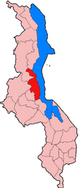
Nkhotakota is a district in the Central Region of Malawi. The capital is Nkhotakota. The district covers an area of 4,259 km² and has a population of 395,897.[1] The word Nkhotakota means "zig-zag" in Chichewa. It is located along the shore of Lake Malawi.
Demographics
At the time of the 2018 Census of Malawi, the distribution of the population of Nkhotakota District by ethnic group was as follows:[2]
- 75.8% Chewa
- 10.4% Tonga
- 3.9% Tumbuka
- 2.1% Lomwe
- 2.3% Ngoni
- 1.9% Yao
- 1.7% Sena
- 0.5% Nyanja
- 0.4% Nkhonde
- 0.4% Mang'anja
- 0.2% Lambya
- 0.1% Sukwa
- 0.2% Others
Government and administrative divisions
There are five National Assembly constituencies in Nkhotakota:[3]
- Nkhotakota - Central
- Nkhotakota - North
- Nkhotakota - North East
- Nkhotakota - South
- Nkhotakota - South East
References

13°00′S 34°05′E / 13.000°S 34.083°E / -13.000; 34.083
 | This Malawi location article is a stub. You can help Wikipedia by expanding it. |
- v
- t
- e


