Nova Scotia Route 358
Major junctionsSouth end  Trunk 1 in Greenwich
Major intersections  Route 341 in Canard
 Route 221 in Canning
North end Rogers Road in Scot's Bay Location Country Canada Province Nova Scotia Highway system
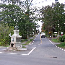
Route 358 in Canning 
100-series Trunk routes Collector roads Scenic routes
 Trunk 1 in Greenwich
 Route 341 in Canard
  Route 221 in Canning
- 100-series
←  Route 357 Route 357 | →  Route 359 Route 359 |
Route 358 is a collector road in the Canadian province of Nova Scotia.
It is located in Kings County and connects Greenwich at Trunk 1 with Scot's Bay. Between Port Williams and Canard, the highway crosses the Canard River and the low fields of the riverbank in a wide curve, tracing the path of the Grand Dyke, built by the Acadians about 1750.[2]
Communities

Parks
- Scots Bay Provincial Park
- Blomidon Provincial Park
- Cape Split Provincial Park Reserve
History

The section of the Collector Highway 358 from Canard to Canning was designated as part of the Trunk Highway 41.
See also
References
- v
- t
- e
- 201
- 202
- 203
- 204
- 205
- 206
- 207
- 208
- 209
- 210
- 211
- 212
- 213
- 214
- 215
- 216
- 217
- 219
- 221
- 223
- 224
- 236
- 239
- 242
- 245
- 246
- 247
- 252
- 253
- 255
- 256
- 276
- 277
- 289
- 301
- 302
- 303
- 304
- 305
- 306
- 307
- 308
- 309
- 311
- 312
- 316
- 318
- 320
- 321
- 322
- 324
- 325
- 326
- 327
- 328
- 329
- 330
- 331
- 332
- 333
- 334
- 335
- 336
- 337
- 340
- 341
- 344
- 347
- 348
- 349
- 354
- 357
- 358
- 359
- 360
- 362
- 366
- 368
- 374
- 376
- 395
 | This Nova Scotia road, road transport or highway-related article is a stub. You can help Wikipedia by expanding it. |
- v
- t
- e


