Peyrilles
Commune in Occitania, France

Coat of arms
Location of Peyrilles

(2020–2026) Stéphane Magot[1]
1
(2021)[2]
46219 /46310
(avg. 259 m or 850 ft)
Peyrilles (French pronunciation: [peʁij]; Occitan: Peirilhas) is a commune in the Lot department in south-western France.[3]
Demographics
People living there are called Peyrillacois in French.
| Year | Pop. | ±% p.a. |
|---|---|---|
| 1968 | 369 | — |
| 1975 | 336 | −1.33% |
| 1982 | 326 | −0.43% |
| 1990 | 340 | +0.53% |
| 1999 | 313 | −0.92% |
| 2007 | 345 | +1.22% |
| 2012 | 388 | +2.38% |
| 2017 | 354 | −1.82% |
| Source: INSEE[4] | ||
Places
-
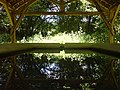
 Washing-place of the Dégagnazès
 -
 Washing-place Dégagnazès
 -
 Castel of Peyrilles
 -
 Church of Peyrilles' parish


See also
References
- ^ "Répertoire national des élus: les maires". data.gouv.fr, Plateforme ouverte des données publiques françaises (in French). 2 December 2020.
- ^ "Populations légales 2021". The National Institute of Statistics and Economic Studies. 28 December 2023.
- ^ INSEE commune file
- ^ Population en historique depuis 1968, INSEE
Wikimedia Commons has media related to Peyrilles.
- v
- t
- e
 Communes of the Lot department
- Albas
- Albiac
- Alvignac
- Anglars
- Anglars-Juillac
- Anglars-Nozac
- Arcambal
- Les Arques
- Assier
- Aujols
- Autoire
- Aynac
- Bach
- Bagnac-sur-Célé
- Baladou
- Bannes
- Barguelonne-en-Quercy
- Le Bastit
- Beauregard
- Béduer
- Bélaye
- Belfort-du-Quercy
- Bellefont-La Rauze
- Belmont-Bretenoux
- Belmont-Sainte-Foi
- Berganty
- Bessonies
- Bétaille
- Biars-sur-Cère
- Bio
- Blars
- Boissières
- Le Bourg
- Boussac
- Le Bouyssou
- Bouziès
- Brengues
- Bretenoux
- Cabrerets
- Cadrieu
- Cahorspref
- Cahus
- Caillac
- Cajarc
- Calamane
- Calès
- Calvignac
- Cambayrac
- Cambes
- Camboulit
- Camburat
- Caniac-du-Causse
- Capdenac
- Carayac
- Cardaillac
- Carennac
- Carlucet
- Carnac-Rouffiac
- Cassagnes
- Castelfranc
- Castelnau-Montratier
- Catus
- Cavagnac
- Cazals
- Cénevières
- Cézac
- Cieurac
- Cœur de Causse
- Concorès
- Concots
- Condat
- Corn
- Cornac
- Couzou
- Cras
- Crayssac
- Crégols
- Cremps
- Cressensac-Sarrazac
- Creysse
- Cuzac
- Cuzance
- Dégagnac
- Douelle
- Duravel
- Durbans
- Escamps
- Esclauzels
- Espagnac-Sainte-Eulalie
- Espédaillac
- Espère
- Espeyroux
- Estal
- Fajoles
- Faycelles
- Felzins
- Figeacsubpr
- Flaujac-Gare
- Flaujac-Poujols
- Floirac
- Floressas
- Fons
- Fontanes
- Fourmagnac
- Francoulès
- Frayssinet
- Frayssinet-le-Gélat
- Frayssinhes
- Frontenac
- Gagnac-sur-Cère
- Gignac
- Gigouzac
- Gindou
- Ginouillac
- Gintrac
- Girac
- Glanes
- Gorses
- Goujounac
- Gourdonsubpr
- Gramat
- Gréalou
- Grézels
- Grèzes
- Issendolus
- Issepts
- Les Junies
- Labastide-du-Haut-Mont
- Labastide-du-Vert
- Labastide-Marnhac
- Labathude
- Laburgade
- Lacapelle-Cabanac
- Lacapelle-Marival
- Lacave
- Lachapelle-Auzac
- Ladirat
- Lagardelle
- Lalbenque
- Lamagdelaine
- Lamothe-Cassel
- Lamothe-Fénelon
- Lanzac
- Laramière
- Larnagol
- Larroque-Toirac
- Latouille-Lentillac
- Latronquière
- Lauresses
- Lauzès
- Laval-de-Cère
- Lavercantière
- Lavergne
- Lendou-en-Quercy
- Lentillac-du-Causse
- Lentillac-Saint-Blaise
- Léobard
- Leyme
- Lherm
- Lhospitalet
- Limogne-en-Quercy
- Linac
- Lissac-et-Mouret
- Livernon
- Loubressac
- Loupiac
- Lugagnac
- Lunan
- Lunegarde
- Luzech
- Marcilhac-sur-Célé
- Marminiac
- Martel
- Masclat
- Mauroux
- Maxou
- Mayrac
- Mayrinhac-Lentour
- Mechmont
- Mercuès
- Meyronne
- Miers
- Milhac
- Molières
- Montamel
- Le Montat
- Montbrun
- Montcabrier
- Montcléra
- Montcuq-en-Quercy-Blanc
- Montdoumerc
- Montet-et-Bouxal
- Montfaucon
- Montgesty
- Montlauzun
- Montredon
- Montvalent
- Nadaillac-de-Rouge
- Nadillac
- Nuzéjouls
- Orniac
- Padirac
- Parnac
- Payrac
- Payrignac
- Les Pechs-du-Vers
- Pern
- Pescadoires
- Peyrilles
- Pinsac
- Planioles
- Pomarède
- Pontcirq
- Porte-du-Quercy
- Pradines
- Prayssac
- Prendeignes
- Promilhanes
- Prudhomat
- Puy-l'Évêque
- Puybrun
- Puyjourdes
- Quissac
- Rampoux
- Reilhac
- Reilhaguet
- Reyrevignes
- Rignac
- Le Roc
- Rocamadour
- Rouffilhac
- Rudelle
- Rueyres
- Sabadel-Latronquière
- Sabadel-Lauzès
- Saignes
- Saillac
- Saint-Bressou
- Saint-Caprais
- Saint-Céré
- Saint-Chamarand
- Saint-Chels
- Saint-Cirgues
- Saint-Cirq-Lapopie
- Saint-Cirq-Madelon
- Saint-Cirq-Souillaguet
- Saint-Clair
- Saint-Denis-Catus
- Saint-Denis-lès-Martel
- Sainte-Colombe
- Saint-Félix
- Saint-Germain-du-Bel-Air
- Saint Géry-Vers
- Saint-Hilaire
- Saint-Jean-de-Laur
- Saint-Jean-Lagineste
- Saint-Jean-Lespinasse
- Saint-Jean-Mirabel
- Saint-Laurent-les-Tours
- Saint-Martin-Labouval
- Saint-Martin-le-Redon
- Saint-Maurice-en-Quercy
- Saint-Médard
- Saint-Médard-de-Presque
- Saint-Médard-Nicourby
- Saint-Michel-de-Bannières
- Saint-Michel-Loubéjou
- Saint-Paul-de-Vern
- Saint-Paul-Flaugnac
- Saint-Perdoux
- Saint-Pierre-Lafeuille
- Saint-Pierre-Toirac
- Saint-Projet
- Saint-Simon
- Saint-Sozy
- Saint-Sulpice
- Saint-Vincent-du-Pendit
- Saint-Vincent-Rive-d'Olt
- Salviac
- Sauliac-sur-Célé
- Sauzet
- Sénaillac-Latronquière
- Sénaillac-Lauzès
- Séniergues
- Sérignac
- Sonac
- Soturac
- Soucirac
- Souillac
- Soulomès
- Sousceyrac-en-Quercy
- Strenquels
- Tauriac
- Terrou
- Teyssieu
- Thédirac
- Thégra
- Thémines
- Théminettes
- Tour-de-Faure
- Touzac
- Trespoux-Rassiels
- Ussel
- Uzech
- Varaire
- Vaylats
- Vayrac
- Viazac
- Vidaillac
- Le Vigan
- Le Vignon-en-Quercy
- Villesèque
- Vire-sur-Lot
- pref: prefecture
- subpr: subprefecture
| Authority control databases: National |
|
|---|
 | This Lot geographical article is a stub. You can help Wikipedia by expanding it. |
- v
- t
- e


