Römerberg
Municipality in Rhineland-Palatinate, Germany

Coat of arms
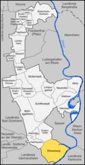
Location of Römerberg within Rhein-Pfalz-Kreis district
(2019–24) Matthias Hoffmann[1] (Greens)
(2022-12-31)[2]
67354
Römerberg is a municipality in the Rhein-Pfalz-Kreis, in Rhineland-Palatinate, Germany. It is situated on the left bank of the Rhine, approximately 5 kilometres (3.1 mi) southwest of Speyer.
History
The municipality of Römerberg was established by the fusion of the municipalities of Berghausen, Heiligenstein and Mechtersheim in 1969. The seat of the municipality is in the village Heiligenstein.
References
- v
- t
- e
Towns and municipalities in Rhein-Pfalz-Kreis
- Altrip
- Beindersheim
- Birkenheide
- Bobenheim-Roxheim
- Böhl-Iggelheim
- Dannstadt-Schauernheim
- Dudenhofen
- Fußgönheim
- Großniedesheim
- Hanhofen
- Harthausen
- Heßheim
- Heuchelheim bei Frankenthal
- Hochdorf-Assenheim
- Kleinniedesheim
- Lambsheim
- Limburgerhof
- Maxdorf
- Mutterstadt
- Neuhofen
- Otterstadt
- Rödersheim-Gronau
- Römerberg
- Schifferstadt
- Waldsee

| Authority control databases: National |
|
|---|
 | This Rhein-Pfalz-Kreis location article is a stub. You can help Wikipedia by expanding it. |
- v
- t
- e


