Sande, Lower Saxony
Municipality in Lower Saxony, Germany

Flag

Coat of arms
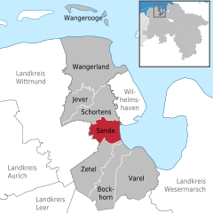
Location of Sande within Friesland district
(2021–26) Stephan Eiklenborg[1]
(2022-12-31)[2]
26452
Sande is a municipality in the district of Friesland, Lower Saxony, Germany. It is situated near the Jade Bight, approximately 7 kilometres (4.3 mi) west of Wilhelmshaven, and 12 kilometres (7.5 mi) southeast of Jever.
Sande is on the railway which links Oldenburg to Wilhelmshaven and Esens. A bypass is planned so that rail traffic for the JadeWeserPort will not pass through the centre of Sande.[3]
-
 Sander Sea
 -
 Ems-Jade Canal


References
- ^ "Stichwahlen zu Direktwahlen in Niedersachsen vom 26. September 2021" (PDF). Landesamt für Statistik Niedersachsen. 13 October 2021.
- ^ "LSN-Online Regionaldatenbank, Tabelle A100001G: Fortschreibung des Bevölkerungsstandes, Stand 31. Dezember 2022" (in German). Landesamt für Statistik Niedersachsen.
- ^ "Freight bypass funding agreed – Railway Gazette". Railway Gazette International. Retrieved 9 August 2012.
- v
- t
- e
Towns and municipalities in Friesland (district)
- Bockhorn
- Jever
- Sande
- Schortens
- Varel
- Wangerland
- Wangerooge
- Zetel

Authority control databases | |
|---|---|
| International |
|
| National |
|
| Geographic |
|
 | This Friesland (district) location article is a stub. You can help Wikipedia by expanding it. |
- v
- t
- e


