Sierra Carapé


Sierra Carapé
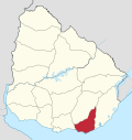
Sierra Carapé or Sierra de Carapé is a hill range located in Maldonado Department, in southern Uruguay. The range crosses the Maldonado Department from west to east and enters the Rocha Department.
Local demarcation
It constitutes the border between the departments of Lavalleja and Maldonado, in south-eastern Uruguay. This hill range constitutes part of a larger range named Cuchilla Grande.
Highest point in Uruguay
This range has the highest point of the country, the Cerro Catedral, with 513.66 metres (1,685.24 feet) of altitude.
See also
- Geography of Uruguay
- Cerro Catedral (Uruguay)#Location and geology
External links
- (in Spanish) Cerro Catedral, Site of the Municipality of Maldonado, Uruguay.
- (in English) Peakbagger.com: Cerro Catedral, Uruguay
- v
- t
- e
 Maldonado Department of Uruguay
Capital:  Maldonado
 Maldonado
- Aiguá
- Garzón
- Maldonado
- Pan de Azúcar
- Piriápolis
- Punta del Este
- San Carlos
- Solís Grande
villages
 | This article about a place in Maldonado Department is a stub. You can help Wikipedia by expanding it. |
- v
- t
- e


