Sievers Mountain
Summit in Pitkin County, Colorado, United States


Sievers Mountain
Location in Colorado
Show map of Colorado
Sievers Mountain
Sievers Mountain (the United States)
Show map of the United StatesElk Mountains[4]
Sievers Mountain is a 12,786-foot (3,897 m) summit in Pitkin County, Colorado, United States.
Description
Sievers Mountain is located 21 miles (34 km) west of the Continental Divide in the Elk Mountains which are a subrange of the Rocky Mountains. The mountain is situated seven miles (11 km) southwest of the community of Aspen in the Maroon Bells–Snowmass Wilderness, on land managed by White River National Forest.[4] Precipitation runoff from the mountain's slopes drains into Willow and Maroon creeks which are tributaries of the Roaring Fork River. Topographic relief is significant as the summit rises 4,000 feet (1,219 m) above Maroon Creek in 1.5 mile (2.4 km) and 1,950 feet (594 m) above Willow Creek in 0.75 mile (1.21 km). The Maroon Bells viewed from Maroon Lake is the most-photographed place in Colorado.[6] The lake was formed when a landslide from the slopes of Sievers Mountain slid into the valley and dammed West Maroon Creek.[7] The mountain's toponym has been officially adopted by the United States Board on Geographic Names.[3]
Climate
According to the Köppen climate classification system, Sievers Mountain is located in an alpine subarctic climate zone with cold, snowy winters, and cool to warm summers.[8] Due to its altitude, it receives precipitation all year, as snow in winter and as thunderstorms in summer, with a dry period in late spring. Climbers can expect afternoon rain, hail, and lightning from the seasonal monsoon in late July and August.
Gallery
-
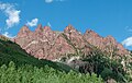
 South aspect of Sievers
 -
 South aspect
 -
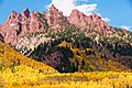 South end of Sievers Mountain above Maroon Lake.
These reddish crags are Maroon Formation. -
 South end of Sievers Mountain


See also
 Mountains portal
- Mountains of Pitkin County, Colorado

References
- ^ a b c d e "Sievers Mountain - 12,786' CO". listsofjohn.com. Retrieved June 14, 2023.
- ^ "Sievers Mountain, Peakvisor.com". Retrieved June 14, 2023.
- ^ a b "Sievers Mountain". Geographic Names Information System. United States Geological Survey, United States Department of the Interior. Retrieved June 14, 2023.
- ^ a b "Sievers Mountain, Colorado". Peakbagger.com. Retrieved June 14, 2023.
- ^ Bruce Bryant, Geologic map of the Maroon Bells quadrangle, Pitkin and Gunnison Counties, Colorado, U.S. Geological Survey, 1969.
- ^ Susan Joy Paul, Stewart M. Green (2022), Best Lake Hikes Colorado, Rowman & Littlefield, ISBN 9781493046836, p. 56.
- ^ Marty Bartholomew (2010), Great Places: Colorado, Wilderness Adventures Press, ISBN 9781932098686, p. 182.
- ^ Peel, M. C.; Finlayson, B. L.; McMahon, T. A. (2007). "Updated world map of the Köppen−Geiger climate classification". Hydrol. Earth Syst. Sci. 11. ISSN 1027-5606.
External links
Wikimedia Commons has media related to Sievers Mountain.
- Sievers Mountain: weather forecast
Places adjacent to Sievers Mountain | ||||||||||||||||
|---|---|---|---|---|---|---|---|---|---|---|---|---|---|---|---|---|
| ||||||||||||||||


- v
- t
- e

- Mount Garfield
- Aspen Mountain
- Capitol Peak
- Castle Peak
- Cathedral Peak
- Chair Mountain
- Crested Butte
- Gothic Mountain
- Italian Mountain
- Maroon Bells
- Mount Emmons
- Mount Owen
- Mount Sopris
- Pyramid Peak
- Snowmass Mountain
- Snowmass Peak
- Treasure Mountain
- Black Mountain (Moffat County)
- Columbus Mountain
- Elk Mountain (Routt County)
- Hahns Peak
- Flat Top Mountain
- Sleepy Cat Peak
- Eagles Nest
- Jacque Peak
- Meridian Peak
- Mount Powell
- The Spider
- Crater Peak
- North Mamm Peak
- Clark Peak
- Arkansas Hills
- Clinton Peak
- Dyer Mountain
- Gemini Peak
- Horseshoe Mountain
- Mount Arkansas
- Mount Bross
- Mount Buckskin
- Mount Democrat
- Mount Lincoln
- Mount Sheridan
- Mount Sherman
- Pacific Peak
- West Buffalo Peak
- Elk Mountain (Grand County)
- Parkview Mountain
- Radial Mountain
- Whiteley Peak
| Sangre de Cristo Range |
|
|---|---|
| Wet Mountains |
|
| Others |
|
| Collegiate Peaks |
|
|---|---|
| Others |
|
- Crystal Peak
- Fletcher Mountain
- Peak 10
- Peak One
- Quandary Peak
- Tenmile Peak
- Bear Mountain
- Blair Mountain
- Chalk Mountains
- Cochetopa Hills
- Dawson Butte
- Diamond Peak
- Flirtation Peak
- Granite Peak
- Grand Hogback
- Grannys Nipple
- Horsefly Peak
- Lead Mountain (Grand County)
- Mount Neva
- Powell Peak
- San Luis Hills
- Storm King Mountain
- Terrible Mountain
- Two Buttes
- Ute Mountain


