Sint Odiliënberg
Village in Limburg, Netherlands

Flag

Coat of arms
51°08′35″N 6°00′10″E / 51.14306°N 6.00278°E / 51.14306; 6.00278
(2021)[1]
6077[1]
Sint Odiliënberg (Dutch pronunciation: [sɪnt oːˈdiljə(m)bɛr(ə)x]) is a village in southeast Netherlands, It is located in Roerdalen, Limburg, in the Roer River valley.
History
Romans settled here very early. Around 700, missionary monks from Northumbria,[3] Saints Wiro, Plechelmus, and Otgerus, built a monastery there, which was important in the Christianisation of the Netherlands.[4] In the time of the Viking invasions the Utrecht clergy found shelter here. At first it was a secular collegiate chapter, which later moved to Roermond in the 14th century. A community of the Canons Regular of the Holy Sepulchre settled on the hill during that period.
The village was first mentioned in the first half of the 9th century as Mons Petri. The current name means "hill of Odile of Alsace".[4]
After the Eighty Years' War, this area came under Spanish rule; it was ceded to the Dutch Republic in 1715. Until the French municipal reorganisation, St. Odiliënberg belonged to the administrative division known as Ambt Montfort. Around 1810 it became a separate commune/municipality. In 1991 the municipality of Sint Odiliënberg merged into Ambt Montfort, which in January 2007 merged into Roerdalen.
Attractions
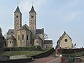
Standing on a hill is a Romanesque basilica with two towers dating from the eleventh century. Next to the basilica is a 10th-century chapel, originally the parish church.
Gallery
-
 Sint Odiliënberg, basilica
 -
 Sint Odiliënberg, windmill: molen van Verbeek


Notable residents
- Connie Palmen, writer, born in St. Odiliënberg
- Geert Chatrou, professional whistler, born in St. Odiliënberg
References
- ^ a b c "Kerncijfers wijken en buurten 2021". Central Bureau of Statistics. Retrieved 25 April 2022.
- ^ "Postcodetool for 6077AA". Actueel Hoogtebestand Nederland (in Dutch). Het Waterschapshuis. Retrieved 25 April 2022.
- ^ Farmer, David. The Oxford Dictionary of Saints (5 rev) OUP, 2011] ISBN 9780199596607
- ^ a b "Sint Odiliënberg - (geografische naam)". Etymologiebank (in Dutch). Retrieved 25 April 2022.
Wikimedia Commons has media related to Sint Odiliënberg.
- v
- t
- e
Populated places in the municipality of Roerdalen
- Herkenbosch [nl]
- Melick [nl]
- Posterholt
- Sint Odiliënberg
- Vlodrop
List of cities, towns and villages in Limburg (Netherlands)
| Authority control databases |
|
|---|


