Tunjuelo River
River in Cundinamarca, Colombia
4°18′25″N 74°07′50″W / 4.3070°N 74.1306°W / 4.3070; -74.1306 • coordinates
Magdalena Basin
Caribbean Sea
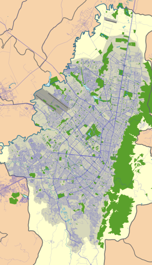
The Tunjuelo or Tunjuelito River is a river on the Bogotá savanna and a left tributary of the Bogotá River. The river, with a length of 73 kilometres (45 mi) originates in the Sumapaz Páramo and flows northward through the Usme Synclinal to enter the Colombian capital Bogotá. There, the river is mostly canalised flowing westward into the Bogotá River. It is one of the three main rivers of the city, together with the Fucha and Juan Amarillo Rivers.
Etymology
The names Tunjuelo and Tunjuelito ("little Tunjuelo") are derived from the Cerro de los Tunjos, also Los Tunjos Lake, named after the tunjos, the religious votive figurines of the indigenous language of the Muisca, who inhabited the Bogotá savanna before the Spanish conquest.[1]
Description


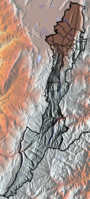
source

mouth
class=notpageimage|
Source and mouth of the Tunjuelo River on the Bogotá savannaThe Tunjuelo River has a total length of 73 kilometres (45 mi) and originates in the Sumapaz Páramo, in the southern part of Bogotá.[2] It flows through the southern part of the Colombian capital, south of the Fucha River, and has the largest drainage basin of the rivers of Bogotá.[3] The river flows through the Usme Synclinal, where the type localities of various geological formations (among others the Marichuela Formation) are situated. The Tunjuelo River forms the border between the localities Usme and Ciudad Bolivar and between the namesake locality Tunjuelito and Ciudad Bolívar. The Tunjuelo River is highly contaminated.[4]
Geology
The Tunjuelo River valley hosts the type localities of various geologic formations of the Altiplano Cundiboyacense.
| Age | Formation | Lithologies | Notes |
|---|---|---|---|
| Pleistocene | Tunjuelo Formation | Conglomerates, sandstones, shales | |
| Early Pliocene | Marichuela Formation | Conglomerates | |
| Late Miocene | |||
| Early Oligocene | Usme Formation | Shales, sandstones, conglomerates | |
| Late Eocene | |||
| Regadera Formation | Sandstones, conglomerates, shales | ||
| Early Eocene | |||
| Bogotá Formation | Mudstones, shales, siltstones, sandstones | ||
| Late Paleocene |
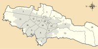
Wetlands


mouth
class=notpageimage|
Wetlands in the Tunjuelo River basin
Three of the fifteen protected wetlands of Bogotá are located in the Tunjuelo River basin.
| Wetland | Location | Altitude (m) | Area (ha) | Notes |
|---|---|---|---|---|
| La Vaca | Kennedy | 2548 | 7.96 | [9] |
| La Isla | Bosa | 2550 | 7.7 | [10] |
| Tibanica | Bosa Soacha | 2542 | 28.8 | [11] |
Gallery
-
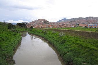 Tunjuelo River in Ciudad Bolívar
 -
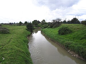
 Tunjuelo River
 -
 Tunjuelo River
 -
 Tunjuelo River in Tunjuelito
 -
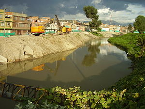 Canalised part of the river


See also
 Colombia portal
 Geography portal


- List of rivers of Colombia
- Eastern Hills, Bogotá
- Bogotá savanna, Sumapaz Páramo
- Fucha River, Juan Amarillo River
References
- ^ Osorio Osorio, 2007, p.29
- ^ Osorio Osorio, 2007, p.12
- ^ (in Spanish) Entre ríos y quebradas Bogotá tiene 198 cuerpos de agua ¿Los conoce?
- ^ (in Spanish) Tunjuelo: olores ofensivos
- ^ Montoya & Reyes, 2005, p.71
- ^ a b Montoya & Reyes, 2005, p.65
- ^ Montoya & Reyes, 2005, p.60
- ^ Montoya & Reyes, 2005, p.57
- ^ Humedal La Vaca
- ^ Humedal La Isla
- ^ Humedal Tibanica
Bibliography
- Montoya Arenas, Diana María, and Germán Alfonso Reyes Torres. 2005. Geología de la Sabana de Bogotá, 1–104. INGEOMINAS.
- Osorio Osorio, Julián Antonio. 2007. El río Tunjuelo en la historia de Bogotá, 1900-1990, 1-116. Alcaldía Mayor de Bogotá. Accessed 2017-02-28.
Further reading
- Bayona, Germán; Omar Montenegro; Agustín Cardona; Carlos Jaramillo; Felipe Lamus; Sara Morón; Luiz Quiroz; María C. Ruíz, and Victor Valencia and Mauricio Parra. 2010. Estratigrafía, procedencia, subsidencia y exhumación de las unidades paleógenas en el Sinclinal de Usme, sur de la zona axial de la Cordillera Oriental - Stratigraphy, provenance, subsidence and exhumation of the Paleogene succession in the Usme Syncline, southern axial zone of the Eastern Cordillera. Geología Colombiana 35. 5-35. Accessed 2017-03-16.
- Guerrero Uscátegui, Alberto Lobo. 1992. Geología e Hidrogeología de Santafé de Bogotá y su Sabana, 1–20. Sociedad Colombiana de Ingenieros.
External links
Wikimedia Commons has media related to Río Tunjuelito.
- (in Spanish) Sistema Hídrico, Bogotá
- v
- t
- e


subdivision
in 20 localities
- Eastern Hills
- Suba Hills
- Bogotá River
- Fucha
- Juan Amarillo
- Soacha
- Tunjuelo
- Savanna
- TvdH Reserve
- Wetlands
- Timeline
- History
- Prehistory
- First inhabitants
- Muisca
- Conquest and foundation
- Post-colonial history
- Categories


