United Nations station (LRT)
Train station in Manila, Philippines
| Preceding station |  Manila LRT | Following station | ||
|---|---|---|---|---|
| Central towards Fernando Poe Jr. | LRT Line 1 | Pedro Gil towards Baclaran | ||
Location | |
|---|---|
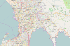  United Nations Location within Metro Manila |
United Nations station is an elevated Light Rail Transit (LRT) station located on the LRT Line 1 (LRT-1) system in Ermita, Manila. Situated above the intersection of Taft Avenue and United Nations Avenue, the station is named after the latter.
United Nations station is the seventh stop from Baclaran and the twelfth from Fernando Poe Jr.
Opened in 1984, the station served as the line's initial northern terminus until Monumento station and nine intermediate stations opened in 1985.[1]
Nearby landmarks

United Nations station is also near educational institutions such as the Technological University of the Philippines, the Philippine Normal University, Adamson University, Santa Isabel College Manila, Emilio Aguinaldo College, Araullo High School and Manila Science High School. It is convenient to several tourist destinations including Rizal Park, the National Museum of Fine Arts, the National Museum of Anthropology, and the National Museum of Natural History. It is also adjacent to the interconnecting Times Plaza, World Health Organization Western Pacific Region office, National Bureau of Investigation headquarters, Medical Center Manila, Manila Doctors Hospital and Waterfront Manila Pavilion Hotel and Casino. It is also near public squares such as Plaza Salamanca and Plaza Rueda, as well as Paco Park. The station was also adjacent to the now-defunct Philam Life Building.
Transportation links
United Nations station is served by buses, jeepneys, and UV Express along Taft Avenue and other nearby routes. Regular taxis, cycle rickshaws, tricycles, and e-tricycles also stop at and near the station.
Gallery
-
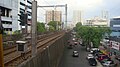 Overview of the area south of United Nations station
 -
 The rails
 -
 Platform area, panoramic view


See also
References
- v
- t
- e
Italicized stations are either under construction, not yet operational, or have been closed.
| |||||||||||
| |||||||||||||
| |||||||||
14°34′56.97″N 120°59′04.78″E / 14.5824917°N 120.9846611°E / 14.5824917; 120.9846611


