Warriors' Path State Park
State park in Tennessee, United States
36°29′29″N 82°29′02″W / 36.49139°N 82.48389°W / 36.49139; -82.48389


Warriors' Path State Park is a 950-acre (3.84 km2) Tennessee State Park in Colonial Heights, Tennessee, an area within the city of Kingsport. It is named for the Great Indian Warpath that was used by the Iroquois in war raids with the Cherokee and other tribes. The park is located around the Fort Patrick Henry Reservoir and Duck Island on the South Fork Holston River. This land was acquired from the Tennessee Valley Authority in 1952.[1]
Park activities and amenities
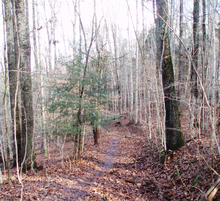
Trails
The park offers a variety of trails available for hiking, biking, and horseback riding. Hiking trails travel through forests and wetlands and range from paved, accessible paths to strenuous climbs. There are also over 8 miles (13 km) of mountain biking trails. Horseback riding trails are available to both independent riders and those interested in guided walks. Stables offer a selection of riding horses and ponies as well as a place for owners to board their horses. Several historic settlements and houses can be seen along the trails.
Aquatics
A marina on Patrick Henry Reservoir offers boat slips as well as canoes and paddle boats for rent. Several public use ramps are available to visitors. Common fish in the lake include crappie, trout, catfish, bream, and bass. An Olympic-size swimming pool is open from Memorial Day to Labor Day.
Campgrounds
The main campground offers 90 campsites, each with tables, grills, water, and electrical hookups. A nearby overflow campground open from Memorial Day to Labor Day contains an additional 40 sites with tables and grills. Campgrounds include bathhouses and dumping stations.
Golf
The Warriors' Path Golf Course is an 18-hole par 72 course on the shores of the Patrick Henry Lake. The course was designed by George Cobb and opened in 1972. Facilities include a driving range, practice green, and practice bunker.[2]
Other facilities
The park has many picnic tables and several pavilions that are available for rent. An accessible playground is open to children of all abilities. Tennis courts, soccer fields, and a 27-hole disc golf course are free to use.
References
External links
- Official Warriors' Path State Park website
- v
- t
- e
Protected areas of Tennessee
| National parks | |
|---|---|
| National historical parks and sites | |
| National Military Parks | |
| National recreation areas | |
| National Trails System | |
| National forests | |
| National Wild and Scenic Rivers | |
| National Wildlife Refuges | |
| Wilderness areas |
|
| Other protected areas |
| East Tennessee state parks |
|
|---|---|
| Middle Tennessee state parks |
|
| West Tennessee state parks | |
| State forests |
|
| State natural areas |
|
| Other |
 | This Sullivan County, Tennessee geography–related article is a stub. You can help Wikipedia by expanding it. |
- v
- t
- e
This article related to a protected area in Tennessee is a stub. You can help Wikipedia by expanding it. |
- v
- t
- e


