Az-Zakariyya
az-Zakariyya زكرية al-Zakariya | |
|---|---|
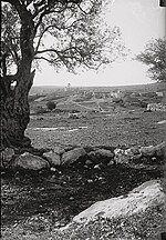 Az-Zakariyya, pra-1926 | |
| Etimologi: "Zachariah" | |
| 31°42′30″N 34°56′50″E / 31.70833°N 34.94722°E / 31.70833; 34.94722 | |
| Grid Palestina | 145/124 |
| Entitas geopolitik | Mandat Palestina |
| Subdistrik | Hebron |
| Tanggal pengosongan | Juni 1950[3] |
| Luas | |
| • Total | 15,320 dunams (15,32 km2 or 5,92 sq mi) |
| Populasi (1945) | |
| • Total | 1,180[1][2] |
| Sebab pengosongan | Pengusiran oleh pasukan Yishuv |
| Wilayah saat ini | Zekharia[4] |
Az-Zakariyya atau Zakaria (bahasa Arab: زكرية[5]) adalah sebuah desa Arab Palestina yang berjarak 25 km dari barat laut kota Hebron (al-Khalil) di Subdistrik Hebron, dan sekitar 12 kilometer (7,5 mi) dari barat laut Bayt Jibrin, yang dikosongkan usai akhir Perang Arab-Israel 1948. Nama desa tersebut diambil dari nama nabi Zakharia,
Referensi
- ^ a b Government of Palestine, Department of Statistics. Village Statistics, April, 1945. Quoted in Hadawi, 1970, p. 50 Diarsipkan 2018-06-23 di Wayback Machine.
- ^ Government of Palestine, Department of Statistics, 1945, p. 23
- ^ Morris, 2004, p. xix, village # 295. Also gives the cause for depopulation
- ^ Kesalahan pengutipan: Tag
<ref>tidak sah; tidak ditemukan teks untuk ref bernamaKhalidi, 1992, p. 226 - ^ Palmer, 1881, p. 338
Daftar pustaka
- Al Jundi, S.; Marlowe, Jen (2011). Hour of Sunlight. Nation Books. ISBN 978-1-56858-631-1. Zakariyya: pp. 1–17
- Baramki, D. C. (1935). "An early Iron Age Tomb at Ez Zahiriyye". Quarterly Of The Department Of Antiquities In Palestine. 4: 109–110.
- Barron, J.B., ed. (1923). Palestine: Report and General Abstracts of the Census of 1922. Government of Palestine.
- Conder, C.R.; Kitchener, H.H. (1883). The Survey of Western Palestine: Memoirs of the Topography, Orography, Hydrography, and Archaeology. 3. London: Committee of the Palestine Exploration Fund.
- Fabri, F. (1893). Felix Fabri (circa 1480–1483 A.D.) vol II, part II. Palestine Pilgrims' Text Society.
- Government of Palestine, Department of Statistics (1945). Village Statistics, April, 1945.
- Guérin, V. (1869). Description Géographique Historique et Archéologique de la Palestine (dalam bahasa French). 1: Judee, pt. 2. Paris: L'Imprimerie Nationale. Pemeliharaan CS1: Bahasa yang tidak diketahui (link)
- Hadawi, S. (1970). Village Statistics of 1945: A Classification of Land and Area ownership in Palestine. Palestine Liberation Organization Research Centre.
- Hartmann, M. (1883). "Die Ortschaftenliste des Liwa Jerusalem in dem türkischen Staatskalender für Syrien auf das Jahr 1288 der Flucht (1871)". Zeitschrift des Deutschen Palästina-Vereins. 6: 102–149.
- Hütteroth, Wolf-Dieter; Abdulfattah, Kamal (1977). Historical Geography of Palestine, Transjordan and Southern Syria in the Late 16th Century. Erlanger Geographische Arbeiten, Sonderband 5. Erlangen, Germany: Vorstand der Fränkischen Geographischen Gesellschaft. ISBN 3-920405-41-2.
- Khalidi, W. (1992). All That Remains: The Palestinian Villages Occupied and Depopulated by Israel in 1948. Washington D.C.: Institute for Palestine Studies. ISBN 0-88728-224-5. ISBN 0-88728-224-5.
- Mills, E., ed. (1932). Census of Palestine 1931. Population of Villages, Towns and Administrative Areas. Jerusalem: Government of Palestine.
- Morris, B. (2004). The Birth of the Palestinian Refugee Problem Revisited. Cambridge University Press. ISBN 978-0-521-00967-6.
- Moudjir ed-dyn al-'Ulaymi (1876). Sauvaire, ed. Histoire de Jérusalem et d'Hébron depuis Abraham jusqu'à la fin du XVe siècle de J.-C. : fragments de la Chronique de Moudjir-ed-dyn.
- Palmer, E.H. (1881). The Survey of Western Palestine: Arabic and English Name Lists Collected During the Survey by Lieutenants Conder and Kitchener, R. E. Transliterated and Explained by E.H. Palmer. Committee of the Palestine Exploration Fund.
- Petersen, Andrew (2001). A Gazetteer of Buildings in Muslim Palestine (British Academy Monographs in Archaeology). 1. Oxford University Press. ISBN 978-0-19-727011-0.
- Pringle, Denys (1993). The Churches of the Crusader Kingdom of Jerusalem: A-K (excluding Acre and Jerusalem). I. Cambridge University Press. ISBN 0 521 39036 2.
- Robinson, E.; Smith, E. (1841). Biblical Researches in Palestine, Mount Sinai and Arabia Petraea: A Journal of Travels in the year 1838. 2. Boston: Crocker & Brewster.
- Schick, C. (1896). "Zur Einwohnerzahl des Bezirks Jerusalem". Zeitschrift des Deutschen Palästina-Vereins. 19: 120–127.
- Socin, A. (1879). "Alphabetisches Verzeichniss von Ortschaften des Paschalik Jerusalem". Zeitschrift des Deutschen Palästina-Vereins. 2: 135–163.
- Sozomen (1855). The Ecclesiastical History of Sozomen: Comprising a History of the Church from A.D. 324 to A.D. 440. Henry G. Bohn.
- Stillman, Yedida Kalfon (1979). Palestinian Costume and Jewelry. Albuquerque: University of New Mexico Press. ISBN 0-8263-0490-7. (A catalog of the Museum of International Folk Art (MOIFA) at Santa Fe's collection of Palestinian clothing and jewellery.)
- van de Velde, C.W.M. (1858). Memoir to Accompany the Map of the Holy Land. Gotha: Justus Perthes.
Pranala luar
- Welcome to Zakariyya
- Zakariyya, Zochrot
- Survey of Western Palestine, Map 17: IAA, Wikimedia commons


