Khulda
Khulda خُلدة Khuldeh | |
|---|---|
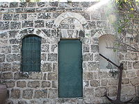 Sisa rumah terbesar di Khulda | |
| 31°49′10″N 34°54′14″E / 31.81944°N 34.90389°E / 31.81944; 34.90389 | |
| Grid Palestina | 141/136 |
| Entitas geopolitik | Mandat Palestina |
| Subdistrik | Ramle |
| Tanggal pengosongan | 6 April 1948[3] |
| Luas | |
| • Total | 9,461 dunams (9,461 km2 or 3,653 sq mi) |
| Populasi (1945) | |
| • Total | 280[1][2] |
| Sebab pengosongan | Serangan militer oleh pasukan Yishuv |
| Wilayah saat ini | Mishmar David[4] |
Khulda (bahasa Arab: خُلدة), juga Khuldeh, adalah sebuah desa Arab Palestina yang berjarak 12 kilometer (7,5 mi) dari selatan Ramla di Mandat Palestina. Dikenal sebagai Huldre oleh pasukan Salibis, desa tersebut juga disebutkan dalam dokumen-dokumen dari zaman Mamluk, Utsmaniyah dan kekuasaan Mandat atas Palestina. Pada perang 1948, desa tersebut dikosongkan sebagai bagian dari Operasi Nachshon dan kemudian dihancurkan. Kibbutz Israel Mishmar David didirikan pada tahun yang sama di atas lahan yang masuk desa tersebut.
Referensi
Daftar pustaka
- Barron, J.B., ed. (1923). Palestine: Report and General Abstracts of the Census of 1922. Government of Palestine.
- Clermont-Ganneau, C.S. (1896). [ARP] Archaeological Researches in Palestine 1873-1874, translated from the French by J. McFarlane. 2. London: Palestine Exploration Fund.
- Conder, C.R.; Kitchener, H.H. (1882). The Survey of Western Palestine: Memoirs of the Topography, Orography, Hydrography, and Archaeology. 2. London: Committee of the Palestine Exploration Fund.
- Conder, C.R. (2009), The Survey of Western Palestine: Arabic and English Name Lists Collected During the Survey, BiblioBazaar, LLC, ISBN 978-1-113-17340-9
- Department of Statistics (1945). Village Statistics, April, 1945. Government of Palestine.
- El-Eini, Roza (2006), Mandated landscape: British imperial rule in Palestine, 1929-1948 (edisi ke-Illustrated), Routledge, ISBN 978-0-7146-5426-3
- Guérin, V. (1869). Description Géographique Historique et Archéologique de la Palestine (dalam bahasa French). 1: Judee, pt. 2. Paris: L'Imprimerie Nationale. Pemeliharaan CS1: Bahasa yang tidak diketahui (link)
- Hadawi, S. (1970). Village Statistics of 1945: A Classification of Land and Area ownership in Palestine. Palestine Liberation Organization Research Center.
- Hartmann, M. (1883). "Die Ortschaftenliste des Liwa Jerusalem in dem türkischen Staatskalender für Syrien auf das Jahr 1288 der Flucht (1871)". Zeitschrift des Deutschen Palästina-Vereins. 6: 102–149.
- Hütteroth, Wolf-Dieter; Abdulfattah, Kamal (1977). Historical Geography of Palestine, Transjordan and Southern Syria in the Late 16th Century. Erlanger Geographische Arbeiten, Sonderband 5. Erlangen, Germany: Vorstand der Fränkischen Geographischen Gesellschaft. ISBN 3-920405-41-2.
- Khalidi, W. (1992). All That Remains: The Palestinian Villages Occupied and Depopulated by Israel in 1948. Washington D.C.: Institute for Palestine Studies. ISBN 0-88728-224-5.
- Mills, E., ed. (1932). Census of Palestine 1931. Population of Villages, Towns and Administrative Areas. Jerusalem: Government of Palestine.
- Morris, B. (2004). The Birth of the Palestinian Refugee Problem Revisited. Cambridge University Press. ISBN 978-0-521-00967-6.
- Moudjir ed-dyn (1876). Sauvaire, ed. Histoire de Jérusalem et d'Hébron depuis Abraham jusqu'à la fin du XVe siècle de J.-C. : fragments de la Chronique de Moudjir-ed-dyn.
- Palmer, E.H. (1881). The Survey of Western Palestine: Arabic and English Name Lists Collected During the Survey by Lieutenants Conder and Kitchener, R. E. Transliterated and Explained by E.H. Palmer. Committee of the Palestine Exploration Fund.
- Petersen, Andrew (2001). A Gazetteer of Buildings in Muslim Palestine: Volume I (British Academy Monographs in Archaeology). Oxford University Press. ISBN 978-0-19-727011-0.
- Pringle, Denys (1993). The Churches of the Crusader Kingdom of Jerusalem: A-K (excluding Acre and Jerusalem). I. Cambridge University Press. ISBN 0 521 39036 2.
- Robinson, E.; Smith, E. (1841). Biblical Researches in Palestine, Mount Sinai and Arabia Petraea: A Journal of Travels in the year 1838. 3. Boston: Crocker & Brewster.
- Socin, A. (1879). "Alphabetisches Verzeichniss von Ortschaften des Paschalik Jerusalem". Zeitschrift des Deutschen Palästina-Vereins. 2: 135–163.
- Sufian, Sandra (1993). Healing the Land and the Nation: Malaria and the Zionist Project in Palestine, 1920-1947. Chicago: University of Chicago Press. ISBN 0-226-77935-1.
Pranala luar
- Welcome To Khulda
- Khulda, Zochrot
- Survey of Western Palestine, Map 16: IAA, Wikimedia commons
- Khulda, from the Khalil Sakakini Cultural Center


