Shawnee, Oklahoma
Shawnee, Oklahoma Shânîheki | |
|---|---|
Kota | |
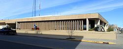 Balai Kota Shawnee, Desember 2016 | |
35°20′33″N 96°56′2″W / 35.34250°N 96.93389°W / 35.34250; -96.93389Koordinat: 35°20′33″N 96°56′2″W / 35.34250°N 96.93389°W / 35.34250; -96.93389 | |
| Negara |  Amerika Serikat Amerika Serikat |
| Negara bagian |  Oklahoma Oklahoma |
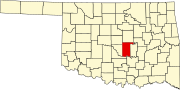
| County | Pottawatomie |
| Pemerintahan | |
| • Jenis | Dewan Walikota |
| • Wali kota | Ed Bolt (D)[butuh rujukan] |
| Luas | |
| • Total | 40,91 sq mi (105,95 km2) |
| • Luas daratan | 38,61 sq mi (99,99 km2) |
| • Luas perairan | 2,30 sq mi (5,96 km2) |
| Ketinggian | 1.053 ft (321 m) |
| Populasi (2020) | |
| • Total | 31.377 |
| • Kepadatan | 812,75/sq mi (313,81/km2) |
| Zona waktu | UTC−6 (Tengah (CST)) |
| • Musim panas (DST) | UTC−5 (CDT) |
| Kode ZIP | 74801, 74802, 74804 |
| Kode area telepon | 405/572 |
| Kode FIPS | 40-66800 [3] |
| ID fitur GNIS | 2411879[2] |
| Situs web | ShawneeOK.org |
Shawnee (Meskwaki: Shânîhekicode: sac is deprecated [4]) adalah kota dan pusat county County Pottawatomie, Oklahoma, Amerika Serikat.[5] The population was 29,857 in 2010, a 4.9 percent increase from the figure of 28,692 in 2000.[6] Kota ini merupakan bagian dari Wilayah Statistik Kombinasi Kota Oklahoma-Shawnee dam kota utama di Wilayah Statistik Mikropolitan Shawnee.
Dengan akses ke Interstate 40, Shawnee berjarak sekitar 45 menit dari sebelah timur downtown Kota Oklahoma. Ke sebelah timur dan timur laut, Shawnee berjarak 112 mil dari Sistem Navigasi Sungai Arkansas McClellan-Kerr, yang menyediakan akses tongkang pengiriman ke Teluk Meksiko.
Rujukan
- ^ "ArcGIS REST Services Directory". United States Census Bureau. Diakses tanggal September 20, 2022.
- ^ a b U.S. Geological Survey Geographic Names Information System: Shawnee, Oklahoma
- ^ "U.S. Census website". United States Census Bureau. Diakses tanggal January 31, 2008.
- ^ Gordon Whittaker, 2005, "A Concise Dictionary of the Sauk Language", The Sac & Fox National Public Library Stroud, Oklahoma. [1]
- ^ "Find a County". National Association of Counties. Diakses tanggal June 7, 2011.
- ^ "Shawnee, OK Population - Census 2010 and 2000 Interactive Map, Demographics, Statistics, Quick Facts - CensusViewer". censusviewer.com. Diakses tanggal April 7, 2018.
Pranala luar
Wikimedia Commons memiliki media mengenai Shawnee, Oklahoma.
Wikisource memiliki teks artikel a 1911 Encyclopædia Britannica about tentang Shawnee, Oklahoma.
Wikivoyage memiliki panduan wisata Shawnee.
- City of Shawnee
- Shawnee Chamber of Commerce
- Shawnee Department of Tourism
Munisipalitas dan komunitas di County Pottawatomie, Oklahoma | ||
|---|---|---|
Ibu kota county: Shawnee | ||
| Kota |
|  |
| Kota kecil |
| |
| CDP |
| |
| Komunitas lainnya |
| |
| Kota hantu |
| |
| Catatan kaki | ‡Permukiman ini juga memiliki porsi yang berada di county yang bersebelahan | |
Templat:Wilayah Metropolitan Kota Oklahoma Templat:Pusat county di Oklahoma
Pengawasan otoritas | |
|---|---|
| Umum |
|
| Perpustakaan nasional |
|
| Lain-lain |
|


