Orange County, California
 | |
| | |
Templat:Use mdy dates
Orange County, California | |||||||
|---|---|---|---|---|---|---|---|
Daerah | |||||||
| Daerah Orange | |||||||
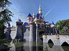
Imej, dari atas ke bawah, ke kiri ke kanan: Pemandangan udara dari pantai Newport Beach, Sleeping Beauty Castle di Disneyland, Huntington Beach Pier, San Clemente Pier, Laguna Beach | |||||||
 Bendera  Mohor | |||||||
 Lokasi dalam negeri California | |||||||
 Bandar dalam daerah | |||||||
| Koordinat: 33°40′N 117°47′W / 33.67°N 117.78°W / 33.67; -117.78Koordinat: 33°40′N 117°47′W / 33.67°N 117.78°W / 33.67; -117.78 | |||||||
| Negara |  Amerika Syarikat Amerika Syarikat | ||||||
| Negeri |  California California | ||||||
| Kawasan | Los Angeles Raya | ||||||
| Diperbadankan | August 1, 1889[1] | ||||||
| Dinamakan bersempena | Buah Oren, dinamakan supaya daerah itu akan kelihatan seperti wilayah semi-tropis, Mediterranean kepada orang-orang dari pantai timur[1] | ||||||
| Kerusi daerah |  Santa Ana Santa Ana | ||||||
| Bandar terbesar |  Anaheim (jumlah penduduk) Anaheim (jumlah penduduk) Irvine (area) Irvine (area) | ||||||
| Pentadbiran | |||||||
| • Badan | Board of Supervisors[2]
| ||||||
| Keluasan | |||||||
| • Jumlah | 948 batu persegi (2,460 km2) | ||||||
| • Tanah | 799 batu persegi (2,070 km2) | ||||||
| • Air | 157 batu persegi (410 km2) | ||||||
| Aras tertinggi | 5,690 ft (1,730 m) | ||||||
| Penduduk (April 1, 2010)[4] | |||||||
| • Jumlah | 3,010,232 | ||||||
| • Estimate (2018)[5] | 3,185,968 | ||||||
| • Kepadatan | 3,200/batu persegi (1,200/km2) | ||||||
| Demonim | Orange Countian | ||||||
| Zon waktu | UTC−8 (Zon Masa Lautan Pasifik) | ||||||
| • Musim panas (DST) | UTC−7 (Waktu Siang Pasifik) | ||||||
| Kod kawasan | 562, 657/714, 949 | ||||||
| GDP | $230 billion[6] | ||||||
| Laman sesawang | ocgov | ||||||


Orange County adalah sebuah daerah yang terletak di kawasan metropolitan Los Angeles di negeri A.S. di California. Sehingga banci 2010, penduduknya ialah 3,010,232,[4] menjadikannya daerah ketiga paling ramai penduduk di California, paling ramai penduduk di A.S., dan lebih ramai penduduk daripada 21 buah negeri A.S..[7] Walaupun kebanyakan pinggiran bandar, ia adalah daerah paling padat kedua yang kedua di negeri ini, di belakang San Francisco County.[8] Empat bandar paling ramai di wilayah ini, Anaheim, Santa Ana (kerusi daerah)[9] Irvine, dan Huntington Beach, masing-masing mempunyai penduduk melebihi 200,000. Beberapa bandar di pesisiran pantai Pasifik, termasuk Pantai Huntington, Newport Beach, Laguna Beach, Dana Point, dan San Clemente.
Orange County dimasukkan ke dalam Los Angeles-Long Beach-Anaheim Kawasan Statistik Metropolitan. Wilayah ini mempunyai 34 bandar diperbadankan. Bandar lama seperti Santa Ana, Anaheim, dan Fullerton mempunyai pusat bandar tradisional sejak abad ke-19, sementara pembangunan komersil yang lebih baru atau " bandar pinggiran" sepanjang I-5 antara Disneyland dan Santa Ana dan antara South Coast Plaza dan Kompleks Perniagaan Irvine, dan kelompok di Irvine Spectrum. Utara dan Tengah Orange County, sementara rumah keluarga tunggal masih lazim, agak lebih urbanized dan padat, sementara di luar Irvine, daerah ini agak kurang padat, walaupun masih bersebelahan, pinggir bandar dan tidak exurban.
Wilayah ini adalah pusat pelancongan, dengan tarikan seperti Disneyland, Knott's Berry Farm, dan beberapa pantai yang popular di sepanjang lebih dari 40 batu (64 km).
Sejarah


Ahli-ahli kumpulan Orang Asli Amerika Tongva, Juaneño, dan Luiseño telah lama mendiami kawasan tersebut. Selepas ekspedisi 1769 Gaspar de Portolà, ekspedisi Sepanyol yang diketuai oleh Junipero Serra menamakan kawasan Valle de Santa Ana (Lembah Saint Anne).[10] Pada 1 November 1776, Mission San Juan Capistrano menjadi penyelesaian pertama Eropah yang pertama. Antara mereka yang datang bersama Portolá ialah José Manuel Nieto dan José Antonio Yorba. Kedua-dua lelaki ini diberi geran tanah—Rancho Los Nietos dan Rancho Santiago de Santa Ana, masing-masing. Para ahli waris Nieto diberikan tanah pada 1834. Ladang Nieto dikenali sebagai Rancho Los Alamitos, Rancho Las Bolsas, dan Rancho Los Coyotes. Yorba pewaris Bernardo Yorba dan Teodosio Yorba juga diberikan Rancho Cañón de Santa Ana (Ladang Ternak Ngarai Santa Ana) dan Rancho Lomas de Santiago, masing-masing. Rancho lain di Orange County telah diberikan oleh kerajaan Mexico semasa tempoh Mexico di Alta California.[11]
Kemarau yang teruk pada tahun 1860-an merosakkan industri semasa, peternakan lembu, dan banyak tanah datang ke dalam milik Richard O'Neill, Sr.,[12] James Irvine dan baron tanah lain. Pada tahun 1887, perak telah ditemui di Santa Ana Mountains, menarik peneroka melalui Santa Fe dan Landasan Kereta Api Pasifik Selatan.

Selepas beberapa percubaan gagal dalam sesi terdahulu, badan perundangan California meluluskan rang undang-undang yang membenarkan bahagian Los Angeles County di selatan Coyote Creek untuk mengadakan referendum mengenai sama ada untuk kekal sebahagian daripada Los Angeles County atau untuk mengasingkan dan membentuk sebuah daerah baru yang dinamakan " Orange "seperti yang diarahkan oleh badan perundangan. Pungutan suara sedemikian memerlukan undi 2/3 untuk pemisahan, dan seterusnya pada 4 Jun 1889, penduduk di selatan Coyote Creek mengundi 2,509 hingga 500 memihak kepada pemisahan. Selepas referendum itu, Los Angeles County memfailkan tiga tindakan undang-undang di mahkamah untuk menghentikan dan menghentikan pemisahan itu daripada berlaku, tetapi percubaan itu sia-sia. Pada 17 Julai 1889, satu referendum kedua diadakan di selatan Coyote Creek untuk menentukan sama ada kerusi daerah daerah menjadi sama ada di Anaheim atau Santa Ana, bersama-sama dengan pilihan raya untuk setiap pegawai daerah. Pada akhirnya, Santa Ana mengalahkan Anaheim dalam referendum tersebut dan dipilih sebagai pegawai yang bersandar, dengan beberapa, termasuk salah satu pelobi utama untuk penciptaan daerah, Henry W. Head, yang dipilih kepada Lembaga Pengawas ketika menjadi anggota Ku Klux Klan (walaupun "Klan tidak semestinya wujud pada masa ini, dengan Bedford [Nathan Bedford Forrest, Grand Wizard of the Klan] secara rasmi memberitahu Klan untuk membubarkan dan membakar semua barang."),[13] dengan anak lelaki Head, Horace Head, yang dipilih sebagai Peguam Daerah tidak lama lagi menjadi daerah, yang dikenali, seperti yang dinyatakan oleh OC Weekly, mengancam "setiap orang Meksiko yang berjalan di depan rumah mereka dengan senapang patah ketika tidak membakar salib di depan rumput, "Bersama dengan Horace Head yang menyokong dan mempertahankan pertalian ayahnya dengan Ku Klux Klan. Dengan referendum yang berlaku, County Orange secara rasmi diperbadankan pada 1 Ogos 1889, sebagaimana yang ditetapkan oleh undang-undang negara.[14] Sejak tarikh pembentukan daerah itu, satu-satunya perubahan geografi yang telah berlaku yang menjejaskan Orange County adalah apabila County dan County Los Angeles bersetuju untuk memperdagangkan tanah di sekitar Coyote Creek untuk menyesuaikan sempadan kedua-dua daerah untuk mematuhi blok bandar.[13][15]
Daerah itu dikatakan telah dinamakan untuk buah jeruk dalam usaha untuk mempromosikan imigrasi dengan mencadangkan syurga semi-tropika – tempat di mana pun dapat berkembang.[16]

Tanaman sitrus lain, alpukat, dan ekstraksi minyak juga penting untuk ekonomi awal. Orange County mendapat manfaat dari 4 Julai 1904, menyiapkan Pacific Electric Railway, sebuah troli yang menghubungkan Los Angeles dengan Santa Ana dan Newport Beach. Pautan yang dibuat Orange County boleh dijadikan tempat percutian hujung minggu untuk selebriti Hollywood awal. Ia dianggap sangat penting bahawa Pasifik menukar namanya ke Huntington Beach untuk menghormati Henry E. Huntington, presiden Pacific Electric dan anak buah Collis Huntington. Pengangkutan semakin bertambah dengan menyelesaikan Laluan Negara dan Laluan A.S. 101 (kini kebanyakannya Interstate 5) pada tahun 1920-an.
Pertanian, seperti yang melibatkan boysenberries yang dibuat terkenal oleh orang asal Buena Park Walter Knott, mula merosot selepas Perang Dunia II. Walau bagaimanapun, kemakmuran daerah melonjak pada masa ini. Penyiapan Interstate 5 pada tahun 1954 membantu menjadikan Orange County sebuah bilik tidur komuniti bagi banyak orang yang berpindah ke California Selatan untuk bekerja dalam bidang aeroangkasa dan pembuatan. Orange County menerima rangsangan lebih lanjut pada tahun 1955 dengan pembukaan Disneyland.
Pada tahun 1969, anak kelahiran kelahiran Yorba Linda yang berasal dari Orange County, Richard Nixon menjadi Presiden Amerika Syarikat ke-37.
Pada tahun 1980-an, Orange County telah menjadi daerah kedua paling ramai penduduk di California kerana penduduk menduduki dua juta untuk pertama kalinya.
Pada tahun 1994, krisis dana pelaburan membawa kepada pendakwaan jenayah bendahari Robert Citron. Daerah ini kehilangan sekurang-kurangnya $1.5 bilion melalui pelaburan berisiko tinggi dalam bon. Kerugian itu dipersalahkan atas derivatif oleh beberapa laporan media. Pada 6 Disember 1994, County Orange diisytiharkan kemuflisan Bab 9,[17] yang mana ia muncul pada 12 Jun, 1996.[18] Kemuflisan Orange County pada masa itu kebankrapan perbandaran terbesar dalam sejarah A.S.[17]
Dalam tahun-tahun kebelakangan ini, konflik kegunaan tanah telah timbul antara kawasan yang ditubuhkan di utara dan kurang maju di selatan. Konflik-konflik ini telah menimbulkan isu-isu seperti pembinaan jalan tol baru dan menaikkan semula pangkalan udara yang dibatalkan. Stesen Udara Marin Corp El Toro telah ditetapkan oleh langkah pengundi pada tahun 1994 untuk dibangunkan menjadi lapangan terbang antarabangsa untuk melengkapi Lapangan Terbang John Wayne yang sedia ada. Tetapi inisiatif pengundi dan tindakan pengadilan yang berikutnya telah menyebabkan pelan lapangan terbang ditangguhkan secara kekal. Sebaliknya, ia menjadi Taman Besar Orange County.[19]
Geography


- Lihat juga: List of rivers of Orange County, California
According to the U.S. Census Bureau, the county has a total area of 948 batu persegi (2,460 km2), of which 791 batu persegi (2,050 km2) is land and 157 batu persegi (410 km2) (16.6%) is water.[20] It is the smallest county by area in Southern California. The average annual temperature is about 68 °F (20 °C).
Orange County is bordered on the southwest by the Pacific Ocean, on the north by Los Angeles County, on the northeast by San Bernardino County, on the east by Riverside County, and on the southeast by San Diego County.
The northwestern part of the county lies on the coastal plain of the Los Angeles Basin, while the southeastern end rises into the foothills of the Santa Ana Mountains. Most of Orange County's population reside in one of two shallow coastal valleys that lie in the basin, the Santa Ana Valley and the Saddleback Valley. The Santa Ana Mountains lie within the eastern boundaries of the county and of the Cleveland National Forest. The high point is Santiago Peak (5,689 kaki (1,734 m)[21]), about 20 bt (32 km) east of Santa Ana. Santiago Peak and nearby Modjeska Peak, just 200 kaki (60 m) shorter, form a ridge known as Saddleback, visible from almost everywhere in the county. The Peralta Hills extend westward from the Santa Ana Mountains through the communities of Anaheim Hills, Orange, and ending in Olive. The Loma Ridge is another prominent feature, running parallel to the Santa Ana Mountains through the central part of the county, separated from the taller mountains to the east by Santiago Canyon.
The Santa Ana River is the county's principal watercourse, flowing through the middle of the county from northeast to southwest. Its major tributary to the south and east is Santiago Creek. Other watercourses within the county include Aliso Creek, San Juan Creek, and Horsethief Creek. In the North, the San Gabriel River also briefly crosses into Orange County and exits into the Pacific on the Los Angeles-Orange County line between the cities of Long Beach and Seal Beach. Laguna Beach is home to the county's only natural lakes, Laguna Lakes, which are formed by water rising up against an underground fault.
Regions of Orange County
Orange County is sometimes divided into northern and southern regions. There are significant political, demographic, economic and cultural distinctions between North and South Orange County.[22] A popular dividing line between the two regions is the Costa Mesa Freeway.
North Orange County, including Anaheim, Fullerton and Santa Ana, was the first part of the county to be developed and is culturally closer to neighboring Los Angeles County. This region is more Hispanic (mostly Mexican) and Asian (predominantly Vietnamese and Korean)[23], more densely populated (Santa Ana is the fifth most densely-populated city in the United States with a population of over 200,000), younger, less wealthy and with higher unemployment. It has more renters, fewer homeowners and more registered Democrats as opposed to Republicans. There are notable exceptions to these general trends, such as strongly Republican Yorba Linda and affluent Anaheim Hills and Villa Park.[22] North Orange County is predominantly flat, giving way to the Santa Ana Mountains in the Northeast.
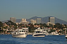
South Orange County is more residential, wealthier, more Republican, less racially diverse and more recently developed. Irvine, the largest city in the region, is an exception to some of these trends, being a major employment center and having an Asian plurality (although Irvine's Asian population tends to be East Asian rather than Southeast Asian). South Orange County almost always includes Irvine,[24] Newport Beach, and the cities to their southeast, including Laguna Beach, Mission Viejo, and San Clemente. Costa Mesa is sometimes included in South County,[25] although it is located predominantly to the west of the Costa Mesa Freeway.[26] Irvine is located in a valley defined by the Santa Ana Mountains and the San Joaquin Hills, while much of South Orange County is very hilly.
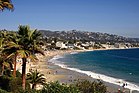
Another region of Orange County is the Orange Coast, which includes the six cities bordering the Pacific Ocean. These are (from northwest to southeast): Seal Beach, Huntington Beach, Newport Beach, Laguna Beach, Dana Point and San Clemente.
Commercial clusters — edge cities
- Lihat juga: Irvine Spectrum dan South Coast Plaza–John Wayne Airport edge city
Older cities like Santa Ana, Anaheim, and Fullerton have traditional downtowns dating back to the 19th century, with Downtown Santa Ana being the home of the county, state and federal institutions. However, far more commercial activity is concentrated in clusters of newer commercial development are found in the county's edge cities, the three largest being
- along Interstate 5 between Disneyland and Downtown Santa Ana
- South Coast Plaza to the Irvine Business Complex, and at
- Irvine Spectrum
Anaheim—Santa Ana edge city


A contiguous strip of commercial development (an edge city) stretches from Disneyland through to MainPlace Mall along the I-5 Santa Ana Freeway,[27][28][29][30][31] straddling the city limits of Anaheim, Garden Grove, Orange, and Santa Ana, and in fact stretching between the original downtowns of those four cities.
Entertainment and cultural facilities include Disneyland Resort, Angel Stadium, Christ Cathedral (formerly Crystal Cathedral), City National Grove of Anaheim - a live concert venue, Discovery Cube Orange County, the Honda Center - home to the Anaheim Ducks of the NHL (National Hockey League), and the Anaheim Convention Center. Health care facilities include CHOC (Children's Hospital of Orange County), Kaiser Permanente Health Pavilion (Anaheim), St. Joseph Hospital (Orange), and the UCI Medical Center.
Retail complexes include Anaheim GardenWalk, Anaheim Marketplace (claiming to be the largest indoor swap meet in Orange County with more than 200 vendors), MainPlace Mall, Orange Town & Country, and The Outlets at Orange, originally a mall named "The City" which was the centerpiece of a planned, 1970s mixed-use development by the same name. There is commercial strip-style development including big box retailers along West Chapman Avenue in Orange (Marshalls, Ralphs), along Harbor Boulevard in Garden Grove (Burlington, Ross Dress for Less), and around Harbor Blvd. and Chapman Ave. in Anaheim (Target).
Major hotels line Harbor Boulevard from Disneyland south to Garden Grove: Grand Legacy at the Park, Hilton, Marriott, Courtyard, DoubleTree Suites, Hampton Inn, Hilton Garden Inn, Homewood Suites, Embassy Suites, Residence Inn, Hyatt Regency, Marriott Suites, Sheraton, and the Great Wolf Lodge. The Orange County Transit Authority studied the corridor as the possible route for a streetcar, a proposal that was dropped in 2018 due to opposition from Anaheim and other city governments.[32]
In addition to suburban-style apartment complexes, Anaheim's Platinum Triangle is undergoing transformation from a low-density commercial and industrial zone into a more urban environment with high-density housing, commercial office towers, and retail space. Anaheim envisions it as a "downtown for Orange County".[33] The 820 ekar (330 he) area undergoing this large-scale redevelopment includes the city's two major sports venues, the Honda Center and Angel Stadium of Anaheim.[34]
National protected areas
- Cleveland National Forest (part)
- Seal Beach National Wildlife Refuge
Demografi
2018
| Penduduk, bangsa, dan pendapatan | |||||
|---|---|---|---|---|---|
| Jumlah penduduk[35] | 3,185,968 | ||||
| Orang Putih[35] | 71.5% | ||||
| Orang Putih bukan Hispanik[35] | 40.1% | ||||
| Orang Hitam atau Amerika Afrika[35] | 2.1% | ||||
| Orang Asli Amerika atau Asli Alaska[35] | 1.0% | ||||
| Orang Asia[35] | 21.4% | ||||
| Orang Asli Hawaii atau Pulau Pasifik[35] | 0.4% | ||||
| Orang Hispanik atau Latino (dari mana-mana bangsa)[36] | 34.2% | ||||
| Pendapatan dolar per kapita 2013-7 pada tahun 2018[36] | $37,603 | ||||
| Pendapatan dolar isi rumah median 2013-7 pada tahun 2018[perlu rujukan] | $81,851 | ||||
2011
| Penduduk, bangsa, dan pendapatan | |||||
|---|---|---|---|---|---|
| Jumlah penduduk[37] | 2,989,948 | ||||
| Orang Putih[37] | 1,852,969 | 62.0% | |||
| Black or African American[37] | 49,513 | 1.7% | |||
| American Indian or Alaska Native[37] | 12,548 | 0.4% | |||
| Asian[37] | 532,499 | 17.8% | |||
| Native Hawaiian or other Pacific Islander[37] | 9,331 | 0.3% | |||
| Hispanic or Latino (of any race)[38] | 994,279 | 33.3% | |||
| Per capita income[39] | $34,416 | ||||
| Median household income[40] | $75,762 | ||||
| Median family income[41] | $85,009 | ||||
Tempat mengikut jumlah penduduk, kaum, dan pendapatan
| Tempat | Jenis[42] | Jumlah penduduk[37] | Putih[37] | Lain-lain[37] [note 1] | Asia[37] | Hitam atau Amerika Afrika[37] | Asli Amerika[37] [note 2] | Hispanik atau Latino (dari mana-mana bangsa)[38] |
|---|---|---|---|---|---|---|---|---|
| Aliso Viejo | City | 47,037 | 71.3% | 11.6% | 13.6% | 3.3% | 0.1% | 17.0% |
| Anaheim | City | 335,057 | 60.2% | 21.8% | 14.6% | 2.7% | 0.7% | 53.0% |
| Anaheim Hills | City | 55,036 | 72.2% | 4.6% | 17.1% | 2.0% | 0.3% | 12.1% |
| Brea | City | 38,837 | 71.0% | 10.1% | 17.5% | 1.0% | 0.5% | 23.6% |
| Buena Park | City | 80,214 | 53.4% | 14.9% | 26.1% | 4.5% | 1.1% | 37.7% |
| Costa Mesa | City | 109,796 | 70.6% | 18.4% | 8.7% | 1.3% | 1.0% | 34.7% |
| Coto de Caza | CDP | 14,974 | 87.7% | 4.8% | 5.9% | 1.5% | 0.0% | 6.1% |
| Cypress | City | 47,610 | 58.5% | 7.5% | 31.1% | 2.1% | 0.7% | 18.1% |
| Dana Point | City | 33,510 | 89.4% | 7.1% | 2.8% | 0.4% | 0.3% | 15.3% |
| Fountain Valley | City | 55,209 | 55.9% | 7.1% | 35.1% | 1.4% | 0.5% | 12.6% |
| Fullerton | City | 134,079 | 53.6% | 19.3% | 23.3% | 3.0% | 0.7% | 33.1% |
| Garden Grove | City | 170,148 | 43.2% | 16.4% | 37.8% | 1.2% | 1.4% | 36.3% |
| Huntington Beach | City | 189,744 | 77.8% | 9.5% | 11.0% | 0.8% | 0.9% | 17.1% |
| Irvine | City | 205,057 | 53.7% | 6.2% | 37.5% | 1.8% | 0.7% | 9.4% |
| Ladera Ranch | CDP | 21,412 | 79.4% | 8.4% | 11.3% | 0.8% | 0.1% | 15.6% |
| Laguna Beach | City | 22,808 | 91.2% | 4.2% | 3.7% | 0.7% | 0.2% | 7.3% |
| Laguna Hills | City | 30,477 | 74.0% | 13.4% | 11.7% | 0.5% | 0.4% | 18.6% |
| Laguna Niguel | City | 62,855 | 79.5% | 8.2% | 9.7% | 2.1% | 0.5% | 12.5% |
| Laguna Woods | City | 16,276 | 88.0% | 1.6% | 9.5% | 0.9% | 0.0% | 3.8% |
| La Habra | City | 60,117 | 54.8% | 35.4% | 7.2% | 2.0% | 0.6% | 58.0% |
| Lake Forest | City | 77,111 | 67.3% | 14.9% | 15.1% | 1.9% | 0.7% | 22.8% |
| La Palma | City | 15,536 | 40.4% | 6.3% | 45.7% | 6.5% | 1.1% | 13.7% |
| Las Flores | CDP | 5,911 | 76.3% | 8.1% | 14.2% | 1.0% | 0.4% | 12.5% |
| Los Alamitos | City | 11,442 | 73.0% | 9.6% | 13.7% | 3.3% | 0.4% | 20.5% |
| Midway City | CDP | 8,052 | 35.2% | 15.5% | 47.1% | 0.2% | 1.9% | 27.7% |
| Mission Viejo | City | 93,076 | 79.8% | 9.1% | 9.2% | 1.3% | 0.6% | 15.3% |
| Newport Beach | City | 84,417 | 87.7% | 3.9% | 7.6% | 0.6% | 0.1% | 7.1% |
| North Tustin | CDP | 24,572 | 84.9% | 4.8% | 8.9% | 0.5% | 0.9% | 12.1% |
| Orange | City | 135,582 | 61.5% | 24.3% | 12.3% | 1.3% | 0.5% | 37.9% |
| Placentia | City | 50,089 | 66.4% | 16.6% | 15.0% | 1.6% | 0.4% | 38.2% |
| Rancho Santa Margarita | City | 47,769 | 78.0% | 9.5% | 10.6% | 1.4% | 0.5% | 16.9% |
| Rossmoor | CDP | 10,099 | 88.0% | 3.3% | 8.1% | 0.4% | 0.2% | 8.9% |
| San Clemente | City | 62,052 | 83.4% | 10.7% | 4.6% | 0.6% | 0.8% | 14.8% |
| San Juan Capistrano | City | 34,455 | 70.6% | 25.3% | 3.3% | 0.3% | 0.5% | 37.7% |
| Santa Ana | City | 325,517 | 42.1% | 46.0% | 10.1% | 1.2% | 0.7% | 78.7% |
| Seal Beach | City | 24,157 | 83.2% | 6.2% | 9.6% | 0.5% | 0.5% | 10.6% |
| Stanton | City | 38,141 | 44.4% | 29.5% | 22.0% | 2.8% | 1.3% | 47.7% |
| Sunset Beach | CDP | 1,486 | 87.7% | 5.1% | 2.7% | 4.5% | 0.0% | 5.5% |
| Tustin | City | 74,625 | 56.6% | 19.5% | 20.8% | 2.0% | 1.1% | 37.9% |
| Villa Park | City | 5,825 | 76.1% | 8.4% | 15.3% | 0.1% | 0.0% | 8.1% |
| Westminster | City | 89,440 | 40.1% | 11.1% | 47.2% | 0.8% | 0.8% | 22.3% |
| Yorba Linda | City | 63,578 | 75.7% | 6.4% | 15.5% | 1.6% | 0.7% | 14.5% |
| Tempat | Jenis[42] | Jumlah penduduk[43] | Pendapatan per kapita[39] | Pendapatan isi rumah median[perlu rujukan] | Pendapatan keluarga median[41] |
|---|---|---|---|---|---|
| Aliso Viejo | City | 47,037 | $44,646 | $99,095 | $113,183 |
| Anaheim | City | 335,057 | $23,109 | $59,330 | $63,180 |
| Anaheim Hills | City | 55,036 | $52,195 | $123,260 | $148,360 |
| Brea | City | 38,837 | $36,195 | $81,278 | $98,159 |
| Buena Park | City | 80,214 | $23,470 | $64,809 | $68,872 |
| Costa Mesa | City | 109,796 | $33,800 | $65,471 | $74,201 |
| Coto de Caza | CDP | 14,974 | $65,625 | $164,385 | $176,686 |
| Cypress | City | 47,610 | $32,815 | $82,954 | $92,276 |
| Dana Point | City | 33,510 | $51,431 | $83,306 | $101,186 |
| Fountain Valley | City | 55,209 | $35,487 | $81,661 | $91,003 |
| Fullerton | City | 134,079 | $30,967 | $69,432 | $78,812 |
| Garden Grove | City | 170,148 | $21,066 | $60,036 | $62,820 |
| Huntington Beach | City | 189,744 | $42,127 | $80,901 | $99,038 |
| Irvine | City | 205,057 | $43,102 | $92,599 | $109,762 |
| Ladera Ranch | CDP | 21,412 | $48,671 | $132,475 | $143,857 |
| Laguna Beach | City | 22,808 | $81,591 | $99,190 | $139,833 |
| Laguna Hills | City | 30,477 | $44,751 | $85,971 | $105,385 |
| Laguna Niguel | City | 62,855 | $51,491 | $100,480 | $119,757 |
| Laguna Woods | City | 16,276 | $36,017 | $35,393 | $50,332 |
| La Habra | City | 60,117 | $24,589 | $63,356 | $69,028 |
| Lake Forest | City | 77,111 | $39,844 | $94,632 | $108,211 |
| La Palma | City | 15,536 | $34,475 | $84,693 | $92,757 |
| Las Flores | CDP | 5,911 | $46,717 | $128,269 | $135,046 |
| Los Alamitos | City | 11,442 | $38,527 | $79,861 | $90,409 |
| Midway City | CDP | 8,052 | $18,610 | $46,714 | $55,168 |
| Mission Viejo | City | 93,076 | $41,436 | $96,420 | $109,693 |
| Newport Beach | City | 84,417 | $80,872 | $108,946 | $151,773 |
| North Tustin | CDP | 24,572 | $55,038 | $109,629 | $119,543 |
| Orange | City | 135,582 | $32,797 | $78,654 | $88,423 |
| Placentia | City | 50,089 | $30,451 | $78,364 | $90,372 |
| Rancho Santa Margarita | City | 47,769 | $41,787 | $104,167 | $116,540 |
| Rossmoor | CDP | 10,099 | $51,210 | $108,427 | $119,727 |
| San Clemente | City | 62,052 | $47,894 | $89,289 | $107,524 |
| San Juan Capistrano | City | 34,455 | $39,097 | $73,806 | $86,744 |
| Santa Ana | City | 325,517 | $16,564 | $54,399 | $53,111 |
| Seal Beach | City | 24,157 | $44,115 | $50,958 | $94,035 |
| Stanton | City | 38,141 | $20,558 | $51,933 | $53,968 |
| Sunset Beach | CDP | 1,486 | $47,415 | $68,036 | $109,125 |
| Tustin | City | 74,625 | $32,854 | $73,231 | $80,963 |
| Villa Park | City | 5,825 | $71,697 | $151,139 | $165,833 |
| Westminster | City | 89,440 | $23,201 | $56,867 | $61,145 |
| Yorba Linda | City | 63,578 | $49,485 | $115,291 | $128,528 |
2010
Templat:US Census population

Banci Amerika Syarikat melaporkan bahawa Orange County mempunyai jumlah penduduk 3,010,232. Cermin perkauman Orange County adalah 1,830,758 (60.8%) orang putih (44.0% orang putih bukan Hispanik), 50,744 (1.7%) orang Amerika Afrika, 18,132 (0.6%) orang Amerika Asli, 537,804 (17.9%) Orang Asia (Banci Amerika Syarikat), 9,354 (0.3% 435,641 (14.5%) dari kaum lain, dan 127,799 (4.2%) dari dua atau lebih kaum. Orang Hispanik atau orang Latino dari mana-mana kaum adalah 1,012,973 orang (33.7%).[44]
Populasi Hispanik dan Latin kebanyakannya berasal dari Mexico; kumpulan ini menyumbang 28.5% penduduk daerah, diikuti oleh Salvadorans (0.8%), Guatemala (0.5%), Puerto Ricans (0.4%), Kuba (0.3%), Colombia (0.3%), dan Peru (0.3% .[45] Santa Ana with its population reportedly 75 percent Hispanic/Latino, is among the most Hispanic/Latino percentage cities in both California and the U.S., esp. of Mexican-American descent.[46] See also Logan Park (Santa Ana), the city's largest and oldest barrio.
Di kalangan penduduk Asia, 6.1% adalah orang Vietnam, diikuti oleh Korea (2.9%), Cina (2.7%), Filipina (2.4%), India (1.4%), Jepun (1.1%), Kemboja (0.2%) Pakistan %), Thailand (0.1%), Indonesia (0.1%), dan orang Laos (0.1%). Menurut KPCC pada tahun 2014, Orange County mempunyai bahagian terbesar penduduk Asia Amerika di California Selatan, di mana satu daripada lima penduduk Asia Amerika.[47] Terdapat juga penduduk Islam yang penting di daerah itu.[48]
| Population reported at 2010 United States Census | |||||||||
|---|---|---|---|---|---|---|---|---|---|
The County | Total Population | White | African American | Native American | Asian | Pacific Islander | other races | two or more races | Hispanic or Latino (of any race) |
| Orange County | 3,010,232 | 1,830,758 | 67,708 | 18,132 | 537,804 | 9,354 | 435,641 | 127,799 | 1,012,973 |
Incorporated cities | Total Population | White | African American | Native American | Asian | Pacific Islander | other races | two or more races | Hispanic or Latino (of any race) |
| Aliso Viejo | 47,823 | 34,437 | 967 | 151 | 6,996 | 89 | 2,446 | 2,737 | 8,164 |
| Anaheim | 336,265 | 177,237 | 9,347 | 2,648 | 49,857 | 1,607 | 80,705 | 14,864 | 177,467 |
| Brea | 39,282 | 26,363 | 1,549 | 190 | 7,144 | 69 | 3,236 | 1,731 | 9,817 |
| Buena Park | 80,530 | 36,454 | 3,073 | 862 | 21,488 | 455 | 14,066 | 4,132 | 31,638 |
| Costa Mesa | 109,960 | 75,335 | 1,640 | 686 | 8,654 | 527 | 17,992 | 5,126 | 39,403 |
| Cypress | 47,802 | 26,000 | 1,444 | 289 | 14,978 | 234 | 2,497 | 2,360 | 8,779 |
| Dana Point | 33,351 | 28,701 | 294 | 229 | 1,064 | 37 | 1,952 | 1,074 | 5,662 |
| Fountain Valley | 55,313 | 31,225 | 1,510 | 229 | 18,418 | 171 | 2,445 | 2,315 | 7,250 |
| Fullerton | 135,161 | 72,845 | 4,138 | 842 | 30,788 | 321 | 21,439 | 5,788 | 46,501 |
| Garden Grove | 170,883 | 68,149 | 3,155 | 983 | 63,451 | 1,110 | 28,916 | 6,119 | 63,079 |
| Huntington Beach | 189,992 | 145,661 | 1,813 | 992 | 21,070 | 635 | 11,193 | 8,628 | 32,411 |
| Irvine | 212,375 | 107,215 | 3,868 | 355 | 83,176 | 334 | 5,867 | 11,710 | 19,621 |
| La Habra | 60,239 | 35,147 | 1,025 | 531 | 5,653 | 103 | 15,224 | 2,556 | 34,449 |
| La Palma | 15,568 | 5,762 | 802 | 56 | 7,483 | 41 | 760 | 664 | 2,487 |
| Laguna Beach | 22,723 | 20,645 | 278 | 61 | 811 | 15 | 350 | 663 | 1,650 |
| Laguna Hills | 30,344 | 22,045 | 520 | 101 | 3,829 | 58 | 2,470 | 1,421 | 6,242 |
| Laguna Niguel | 62,979 | 50,625 | 877 | 219 | 5,459 | 87 | 3,019 | 2,793 | 8,761 |
| Laguna Woods | 16,192 | 14,133 | 110 | 24 | 1,624 | 10 | 90 | 201 | 650 |
| Lake Forest | 77,264 | 54,341 | 1,695 | 384 | 10,115 | 191 | 7,267 | 3,671 | 19,024 |
| Los Alamitos | 11,449 | 8,131 | 324 | 51 | 1,471 | 50 | 726 | 696 | 2,418 |
| Mission Viejo | 93,305 | 74,493 | 1,710 | 379 | 8,462 | 153 | 4,332 | 4,276 | 15,877 |
| Newport Beach | 85,186 | 74,357 | 616 | 223 | 5,982 | 114 | 1,401 | 2,493 | 6,174 |
| Orange | 136,416 | 91,522 | 3,627 | 993 | 15,350 | 352 | 20,567 | 5,405 | 52,014 |
| Placentia | 50,533 | 31,373 | 914 | 386 | 7,531 | 74 | 8,247 | 2,008 | 18,416 |
| Rancho Santa Margarita | 47,853 | 37,421 | 887 | 182 | 4,350 | 102 | 2,674 | 2,237 | 8,902 |
| San Clemente | 63,522 | 54,605 | 511 | 363 | 2,333 | 90 | 3,433 | 2,287 | 10,702 |
| San Juan Capistrano | 34,593 | 26,664 | 293 | 286 | 975 | 33 | 5,234 | 1,208 | 13,388 |
| Santa Ana | 324,528 | 148,838 | 6,356 | 3,260 | 34,138 | 976 | 120,789 | 11,671 | 253,928 |
| Seal Beach | 24,168 | 20,154 | 279 | 65 | 2,309 | 58 | 453 | 850 | 2,331 |
| Stanton | 38,186 | 16,991 | 3,358 | 405 | 8,831 | 217 | 9,274 | 1,610 | 19,417 |
| Tustin | 75,540 | 39,729 | 2,722 | 442 | 15,299 | 268 | 14,499 | 3,581 | 30,024 |
| Villa Park | 5,812 | 4,550 | 92 | 34 | 854 | 1 | 162 | 169 | 598 |
| Westminster | 89,701 | 32,037 | 2,849 | 397 | 42,597 | 361 | 10,229 | 3,231 | 21,176 |
| Yorba Linda | 64,234 | 48,246 | 835 | 230 | 10,030 | 85 | 2,256 | 2,552 | 9,220 |
Census-designated places | Total Population | White | African American | Native American | Asian | Pacific Islander | other races | two or more races | Hispanic or Latino (of any race) |
| Coto de Caza | 14,866 | 13,094 | 132 | 26 | 878 | 20 | 174 | 542 | 1,170 |
| Ladera Ranch | 22,980 | 17,899 | 335 | 54 | 2,774 | 27 | 624 | 1,267 | 2,952 |
| Las Flores | 5,971 | 4,488 | 91 | 23 | 780 | 12 | 261 | 316 | 984 |
| Midway City | 8,485 | 2,884 | 71 | 65 | 3,994 | 40 | 1,165 | 266 | 2,467 |
| North Tustin | 24,917 | 20,836 | 148 | 104 | 1,994 | 52 | 908 | 875 | 3,260 |
| Rossmoor | 10,244 | 8,691 | 84 | 36 | 838 | 29 | 168 | 398 | 1,174 |
Unincorporated communities | Total Population | White | African American | Native American | Asian | Pacific Islander | other races | two or more races | Hispanic or Latino (of any race) |
| All others not CDPs (combined) | 32,726 | 20,572 | 4,365 | 290 | 3,934 | 144 | 6,113 | 1,272 | 13,247 |
2000
As of the census[49] of 2000, there were 2,846,289 people, 935,287 households, and 667,794 families living in the county, making Orange County the second most populous county in California. The population density was 1,392/km2 (3,606/sq mi). There were 969,484 housing units at an average density of 474/km2 (1,228/sq mi). The racial makeup of the county was 64.8% White, 13.6% Asian, 1.7% African American, 0.7% Native American, 0.3% Pacific Islander, 14.8% from other races, and 4.1% from two or more races. 30.8% are Hispanic or Latino of any race. 8.9% were of German, 6.9% English and 6.0% Irish ancestry according to Census 2000. 58.6% spoke only English at home; 25.3% spoke Spanish, 4.7% Vietnamese, 1.9% Korean, 1.5% Chinese (Cantonese or Mandarin) and 1.2% Tagalog.
In 1990, still according to the census[50] there were 2,410,556 people living in the county. The racial makeup of the county was 78.6% White, 10.3% Asian or Pacific Islander, 1.8% African American, 0.5% Native American, and 8.8% from other races. 23.4% were Hispanic or Latino of any race.
Out of 935,287 households, 37.0% had children under the age of 18 living with them, 55.9% married couples were living together, 10.7% had a female householder with no husband present, and 28.6% were non-families. 21.1% of all households were made up of individuals and 7.2% had someone living alone who was 65 years of age or older. The average household size was 3.00 and the average family size was 3.48.
Ethnic change has been transforming the population. By 2009, nearly 45 percent of the residents spoke a language other than English at home. Whites now comprise only 45 percent of the population, while the numbers of Hispanics grow steadily, along with Vietnamese, Korean and Chinese families. The percentage of foreign-born residents jumped to 30 percent in 2008 from 6 percent in 1970. The mayor of Irvine, Sukhee Kang, was born in Korea, making him the first Korean-American to run a major American city. “We have 35 languages spoken in our city,” Kang observed.[51] The population is diverse age-wise, with 27.0% under the age of 18, 9.4% from 18 to 24, 33.2% from 25 to 44, 20.6% from 45 to 64, and 9.9% 65 years of age or older. The median age is 33 years. For every 100 females, there were 99.0 males. For every 100 females age 18 and over, there were 96.7 males.
The median income for a household in the county was $61,899, and the median income for a family was $75,700 (these figures had risen to $71,601 and $81,260 respectively as of a 2007 estimate[52]). Males had a median income of $45,059 versus $34,026 for females. The per capita income for the county was $25,826. About 7.0% of families and 10.3% of the population were below the poverty line, including 13.2% of those under age 18 and 6.2% of those age 65 or over.
Residents of Orange County are known as "Orange Countians".[53]
Agama
Pada tahun 2014, daerah ini mempunyai 1,075 pertubuhan keagamaan, yang paling keenam daripada semua wilayah AS.[54]
Orange County adalah asas untuk beberapa organisasi keagamaan:
- Newport Beach California Temple, salah satu daripada empat kuil yang dikendalikan oleh Gereja Yesus Kristus Orang Suci Zaman Akhir di California Selatan.
- Pendeta Crystal Cathedral Robert Schuller berada di Garden Grove. Sebagai sebahagian daripada proses muflis, ia dijual kepada Gereja Katolik.
- Pusat Islam Irvine, yang telah menaikkan lebih $ 5.5 juta untuk projek pengembangannya (sehingga Oktober 2018).[55]
- Institut Islam Orange County, sebuah Pusat Islam di Orange County, yang terletak di Anaheim dan ditubuhkan pada tahun 1991.[56]
- Persatuan Islam Orange County di Garden Grove, yang ditubuhkan pada tahun 1976 dan merupakan salah satu masjid terbesar di Amerika Syarikat.
- Islamic Center of Santa Ana (ICSA), which opened a new $2.6 million facility in 2017.[57]
- Yayasan Islam County Orange, yang terletak di Mission Viejo.[58]
- Pusat Pendidikan Islam di Orange County (IECOC), terletak di Costa Mesa[59]
- Forty Martyrs Armenian Apostolic Church,[60] located in Santa Ana is one of two Armenian Apostolic Church, otherwise referred to as "Armenian Orthodox Church" or "Gregorian Church" in Orange County.
- Gereja Armenia St. Mary,[61] located in Costa Mesa is one of two Armenian Apostolic Church, jika tidak disebut sebagai "Gereja Ortodoks Armenia" atau "Gereja Gregorian" di Orange County.
- Keluarga Antarabangsa, yang juga dikenali sebagai "Anak-Anak Tuhan", ditubuhkan pada tahun 1968 di Huntington Beach oleh David Berg.
- Chuck Smith, pemimpin awal dalam pergerakan Yesus pergerakan Yesus dan pengasas Calvary Chapel di Costa Mesa.
- Kuil Pao Fa di Irvine adalah salah satu biara dan kuil terbesar di Amerika Serikat.
- The Purpose Driven Life pengarang Rick Warren dan Saddleback Church (gereja terbesar di California) berada di Lake Forest.
- Keuskupan Roman Katolik Orange] dipimpin oleh Bishop Kevin Vann. Terdapat kira-kira 1.04 juta orang Katolik di Orange County.[62]
- Rangkaian Penyiaran Trinity bermula sebagai Channel 40 di Tustin, sekarang di Costa Mesa.
- Biara-biara Persatuan Vedanta California Selatan | Vedanta Society]] dan St. Biara Michael terletak di Trabuco Canyon.
- Pergerakan Vineyard Christian Fellowship bermula di Orange County.
- Jain Center of Southern California di Buena Park, pusat terbesar untuk pengikut kepercayaan Jain, yang awalnya dimulakan oleh Jains dari India
- Pusat Sikh Orange County terletak di Santa Ana
- Pusat Sikh Buena Park - Gurdwara Singh Sabha
- Tuai Orange County di Irvine. Juga memegang Perang Salib Harvest di Stadium Anaheim.
- Living Stream Ministry beribu pejabat di Anaheim dan menjadi tuan rumah beberapa persidangan Kristen setahun.
- Pusat Buddha Orange County di Laguna Hills, sebahagian daripada Soka Gakkai International
Ekonomi
Bisines

Orange County adalah ibu pejabat banyak syarikat Fortune 500 termasuk Ingram Micro (#218) dan First American Corporation (#361) di Santa Ana, Broadcom (#150) di Irvine, Western Digital (#152) di Lake Forest, dan Pacific Life (#298) di Newport Beach. Irvine adalah rumah dari banyak syarikat permulaan dan juga merupakan rumah ibu pejabat Fortune 1000 untuk Allergan, Edwards Lifesciences, Epicor, dan Sun Healthcare Group. Lain-lain Fortune 1000 syarikat di Orange County termasuk Beckman Coulter di Brea, Quiksilver di Huntington Beach dan Apria Healthcare Group di Lake Forest. Irvine juga merupakan syarikat teknologi terkenal seperti pembuat PC Gateway Inc., pengilang penghantar Linksys, pembuat video / komputer Blizzard Entertainment, dan pengeluar produk dalam pesawat Panasonic Avionics Corporation. Juga, Mercedes-Benz Classic Center USA yang berprestij terletak di City of Irvine. Banyak ibu pejabat serantau untuk perniagaan antarabangsa yang tinggal di Orange County seperti Mazda, Toshiba, Toyota, Samsung, Kia, di City of Irvine, Mitsubishi di Kota Cypress, Kawasaki Motors di Foothill Ranch, dan Hyundai di City of Fountain Valley. Fesyen adalah satu lagi industri penting untuk Orange County. Oakley, Inc. beribu pejabat di Lake Forest. Hurley International beribu pejabat di Costa Mesa. Kedua-dua firma keselamatan siber rangkaian Milton Security Group dan syarikat kasut Pleaser USA, Inc. terletak di Fullerton. St. John beribu pejabat di Irvine. Tustin, adalah rumah kepada Ricoh Elektronik, Pembiayaan Baru Amerika, dan Safmarine. Wet Wet beribu pejabat di Lake Forest. PacSun beribu pejabat di Anaheim.[63] Restoran seperti Taco Bell, El Pollo Loco, Burger In-N-Out, Jumper Klaim, Marie Callender, Wienerschnitzel ibu pejabat di bandar Irvine juga. Del Taco beribu pejabat di Lake Forest. Gaikai juga mempunyai ibu pejabatnya di Orange County.
Membeli belah

Belanja di Orange County berpusat di sekitar pusat membeli-belah serantau, kotak besar pusat kuasa dan pusat membeli-belah yang lebih kecil. South Coast Plaza di Costa Mesa adalah pusat membeli-belah terbesar di California, yang ketiga terbesar di Amerika Syarikat, dan 31 terbesar di dunia. Pusat perbelanjaan serantau lain termasuk (dari utara ke selatan): Brea Mall, Village at Orange, Outlets at Orange, MainPlace Santa Ana, Westminster Mall, Bella Terra di Huntington Beach, Tustin dan Irvine , Irvine Spectrum Centre, Fesyen Pulau di Newport Beach, Lima Lagunas dan The Shops at Mission Viejo. Downtown Disney dan Anaheim GardenWalk adalah pusat membeli-belah dan hiburan khusus yang bertujuan untuk pengunjung. Pusat kuasa termasuk La Habra Marketplace, Anaheim Plaza dan Anaheim Town Square. Terdapat satu pusat membeli-belah utama, The Outlet di San Clemente.[64]
Pelancongan
Pelancongan kekal sebagai aspek penting dalam ekonomi Orange County. Anaheim adalah pusat pelancongan utama, dengan Disneyland Resort di Disneyland menjadi taman tema kedua yang paling banyak dikunjungi di dunia. Juga, Knotts Berry Farm mendapat sekitar 7 juta pelawat setiap tahun dan terletak di bandar Buena Park. Pusat Konvensyen Anaheim memegang banyak konvensyen utama sepanjang tahun. Resorts di Pantai Bandar menerima pengunjung sepanjang tahun kerana berdekatan dengan pantai, laluan berbasikal, laluan mendaki gunung, padang golf, membeli-belah dan makan.
Budaya makanan
Seperti yang baru-baru ini sebagai tahun 1990-an, restoran-restoran memenangi anugerah di Orange County kebanyakannya terdiri daripada restoran-restoran rantaian nasional dengan makanan keselesaan tradisional Amerika atau Tex-Mex. Pada akhir 1990-an, Tim dan Liza Goodell dengan chef Florent Marneau, dan David Wilhelm, menubuhkan kumpulan masakan masakan yang memaparkan masakan nouvelle, burger gourmet dan banyak lagi. Pendaftaran Orange County menyatakan bahawa "titik tip" datang pada tahun 2007 apabila Marneaus mengasaskan Marché Moderne (sejak berpindah ke Crystal Cove), dan Chef Top tukang masak Amar Santana membuka cabang Charlie Palmer (ditutup 2015),[65] kedua-duanya di South Coast Plaza. Santana menyusul pembukaan restoran Broadway dan Vaca. Chef Top Chef lain diikuti dengan restoran mereka sendiri termasuk Brian Huskey (Tackle Box), Shirley Chung (Dua Puluh Lapan), Jamie Gwen dari Cutthroat Kitchen, dan dari The Great Food Truck Race, Jason Quinn (tukang masak) (Playground), yang juga membuka tiga berdiri di 4th Street Market[66] food hall in Downtown Santa Ana in 2016.[67]
Dewan makan dengan vendor gourmet termasuk 42,000-kaki-persegi (3,900 m2) Anaheim Packing District, Pasar Jalan ke-4 di Downtown Santa Ana, Lot 579 Huntington Beach, Dewan Makanan Perdagangan di Irvine,[68] OC Mix di Costa Mesa, dan Sumber OC di Buena Park.[69]
Pada 2019, Panduan Michelin memberi bintang untuk pertama kalinya ke restoran Orange County, menganugerahkan Hana Re dan Taco Maria setiap bintang.[70]
Orang yang terkenal
Lihat juga
- Senarai muzium di Orange County, California
- Daftar Pendaftaran Tempat Sejarah Negara di Orange County, California
- Orange County High School of Arts
- Orange County Fair (California)
- Orange County (filem)
- Sistem Perpustakaan Santiago
Nota
Rujukan
- ^ a b "Orange County Historical Society: History Articles :: The Birth of Orange County". Orangecountyhistory.org. Dicapai pada November 17, 2018.
- ^ "Board of Supervisors". Orange County, California. Dicapai pada Mac 27, 2019.
- ^ "Santiago Peak". Peakbagger.org. Dicapai pada Januari 30, 2015.
- ^ a b "Orange County QuickFacts". United States Census Bureau. Diarkibkan daripada yang asal pada Julai 16, 2011. Dicapai pada April 4, 2016.
- ^ Ralat petik: Tag
<ref>tidak sah; teks bagi rujukanUSCensusEst2018tidak disediakan - ^ "GDP by County - U.S. Bureau of Economic Analysis (BEA)". www.bea.gov.
- ^ "American FactFinder". United States Census Bureau. Dicapai pada Julai 10, 2014.
- ^ "California Population Density County Rank". USA.com. Dicapai pada Ogos 14, 2013.
- ^ "Find a County". National Association of Counties. Diarkibkan daripada yang asal pada Mei 3, 2015. Dicapai pada Jun 7, 2011.
- ^ Phil Brigandi (Mac 9, 2007). "A brief history of Orange County" (PDF). County of Orange. Diarkibkan daripada yang asal (PDF) pada Mei 28, 2009. Dicapai pada Mei 28, 2009.
- ^ Spanish and Mexican Ranchos of Orange County Diarkibkan Julai 26, 2011, di Wayback Machine
- ^ "The Reserve at Rancho Mission Viejo: A Rich History". Rancho Mission Viejo.
- ^ a b PROFILES IN OC PIONEERS WHO WERE KLAN MEMBERS: HENRY W. HEAD, OC FOUNDING FATHER, March 15, 2011
- ^ Masters, Nathan (Ogos 16, 2013). "How Orange County Seceded from Los Angeles". KCET. Dicapai pada Disember 28, 2018.
- ^ The Birth of Orange County, 2010
- ^ Sleeper, Jim. "How Orange County Got Its Name" (1974). [1]. Retrieved December 10, 2014.
- ^ a b "Orange County Goes Bust". Time Magazine. Disember 19, 1994.
- ^ "When Government Fails: The Orange County Bankruptcy A Policy Summary" (PDF). Public Policy Institute of California. Diarkibkan daripada yang asal (PDF) pada Jun 17, 2014. Dicapai pada September 29, 2014.
- ^ Guide to the Collection on the Development of the El Toro Airport. Online Archive of California. Retrieved on January 21, 2010.
- ^ "2010 Census Gazetteer Files". United States Census Bureau. Ogos 22, 2012. Dicapai pada September 28, 2015.
- ^ Templat:Cite ngs
- ^ a b University of California, Irvine Community and Labor Project; UCLA Labor Center (Julai 2014). "Orange County on the Cusp of Change" (PDF). Dicapai pada September 12, 2016.
- ^ "Orange County 2010 Census Demographic Profiles" (PDF). US Census Bureau. Dicapai pada Januari 23, 2020 – melalui Cal State Fullerton.
- ^ "Vacanies Are Up in South OC Offices". Los Angeles Times. Jun 1, 2001. Dicapai pada Jun 22, 2019.
- ^ "South Orange County", REMAX site
- ^ "Study Sees Jump in South OC Population", Los Angeles Times, October 18, 1986
- ^ Gewerz, Catherine (September 30, 1991). "County Losing the 'Sub' from Suburb : Trend: The author of a new book says several areas of O.C. have evolved from bedroom communities into urban centers called 'Edge Cities.'". Los Angeles Times. Dicapai pada Jun 25, 2019.
- ^ Strickland, Daryl (Disember 28, 1998). "Hubs of Commerce Point to Solid Future: 'Urban nodes' help direct growth and redefine older downtown cores". Los Angeles Times (Orange County edition). m/s. A1, A11 (O.C. edition)/103, 113. Dicapai pada Jun 30, 2019.
- ^ Schoch, Deborah (Disember 31, 1995). "Nearing 2000, Orange County Faces Its Destiny as an Urban Center". Los Angeles Times, Orange County edition. m/s. 1. Dicapai pada Jun 30, 2019.
- ^ "Eastward, Ho! : Southern Californians Are Headed Inland, to the Area Around the Ontario Airport the Newest Edge City in the Region That Invented the Concept". Los Angeles Times. Mac 15, 1992. Dicapai pada Jun 30, 2019.
- ^ Garreau, Joel (1991). Edge City. Dicapai pada Jun 24, 2019.
- ^ Final Report Central Harbor Boulevard Transit Corridor Study (PDF). Orange County Transportation Authority. m/s. 117. Dicapai pada Julai 3, 2019.
- ^ Khouri, Andrew (Januari 15, 2015). "Anaheim developments revive city's vision of a new downtown for O.C." Los Angeles Times. Dicapai pada Januari 15, 2015.
- ^ Marroquin, Art (Oktober 18, 2015). "Platinum Triangle development taking shape near Angel Stadium, Disneyland". The Orange County Register. Dicapai pada Disember 14, 2015.
- ^ a b c d e f g U.S. Census Bureau. American Community Survey, 2011 American Community Survey 5-Year Estimates, Table B02001. "Quick Facts, Orange County, California". Retrieved October 26, 2013.
- ^ a b U.S. Census Bureau. American Community Survey, 2018 American Community Survey 5-Year Estimates. "Quick Facts, Orange County, California", U.S. Census bureau. Retrieved July 16, 2019.
- ^ a b c d e f g h i j k l U.S. Census Bureau. American Community Survey, 2011 American Community Survey 5-Year Estimates, Table B02001. American FactFinder. Retrieved October 26, 2013.
- ^ a b U.S. Census Bureau. American Community Survey, 2011 American Community Survey 5-Year Estimates, Table B03003. American FactFinder. Retrieved October 26, 2013.
- ^ a b U.S. Census Bureau. American Community Survey, 2011 American Community Survey 5-Year Estimates, Table B19301. American FactFinder. Retrieved October 21, 2013.
- ^ U.S. Census Bureau. American Community Survey, 2011 American Community Survey 5-Year Estimates, Table B19013. American FactFinder. Retrieved October 21, 2013.
- ^ a b U.S. Census Bureau. American Community Survey, 2011 American Community Survey 5-Year Estimates, Table B19113. American FactFinder. Retrieved October 21, 2013.
- ^ a b U.S. Census Bureau. American Community Survey, 2011 American Community Survey 5-Year Estimates. American FactFinder. Retrieved October 21, 2013.
- ^ U.S. Census Bureau. American Community Survey, 2011 American Community Survey 5-Year Estimates, Table B01003. American FactFinder. Retrieved October 21, 2013.
- ^ Templat:USCensus2010CA
- ^ "American FactFinder". U.S. Census Bureau. 2010. Diarkibkan daripada yang asal pada Februari 12, 2011. Dicapai pada September 14, 2012.
- ^ ENG, LILY; SCHWARTZ, BOB (Februari 26, 1991). "City's Latinos on the Grow : Majority: Santa Ana's Hispanics make up 65% of the population and have recorded solid gains, but some still say they are ignored by City Hall". Articles.latimes.com.
- ^ Josie Huang (Julai 8, 2014). "Report: As Asian-American population grows in Orange County, so do needs". KPCC. Dicapai pada Disember 11, 2014.
- ^ Michelle Woo (Mei 15, 2013). "Nahda Designs: Haute Hijab". ocweekly.com. Diarkibkan daripada yang asal pada September 13, 2014.
- ^ "American FactFinder". United States Census Bureau. Dicapai pada Mei 14, 2011.
- ^ "American FactFinder". United States Census Bureau. Dicapai pada Januari 31, 2008.
- ^ Adam Nagourney, "Orange County Is No Longer Nixon Country," New York Times, Aug. 30, 2010.
- ^ "Factfinder - Orange County, CA". Diarkibkan daripada yang asal pada Jun 6, 2011. Dicapai pada Disember 14, 2009.
- ^ Dickson, Paul (2006). Labels for Locals: What to Call People from Abilene to Zimbabwe (ed. Revised). HarperCollins. m/s. 174. ISBN 978-0-06-088164-1. Dicapai pada Februari 10, 2011.
Orange County, California. Orange Countian.
- ^ "Social Capital Variables Spreadsheet for 2014". PennState College of Agricultural Sciences, Northeast Regional Center for Rural Development. Disember 8, 2017. Dicapai pada Disember 30, 2019.
- ^ "New Site Update - The Islamic Center of Irvine". Icoi.net.
- ^ "mission-vision – Islamic Institute of Orange County - Masjid Omar AlFarouk". Iioc.com.
- ^ "About Us – ICSA Masjid". icsamasjid.net.
- ^ "The Organization – Orange County Islamic Foundation". Ocif.org.
- ^ http://iecoc.org. "Start of IECOC - IECOC - Islamic Educational Center of Orange County". Iecoc.org.
- ^ "Forty Martyrs Armenian Apostolic Church".
- ^ "stmaryarmenianchurch".
- ^ "The History of the Diocese of Orange County". The Roman Catholic Diocese of Orange. Diarkibkan daripada yang asal pada September 15, 2008.
- ^ Learn more about PacSun Diarkibkan Julai 28, 2011, di Wayback Machine. Shop.pacsun.com. Retrieved on July 17, 2013.
- ^ "Opening Day: 18 Years in the Making Outlets at San Clemente Welcome Shoppers Today". The Orange County Register.
- ^ https://www.latimes.com/socal/daily-pilot/news/tn-dpt-me-0306-charlie-palmer-20150305-story.html
- ^ Luna, Nancy (Januari 22, 2016). [Food hall shake up? Playground’s Jason Quinn closing three 4th Street Market food stands; four new restaurants coming Food hall shake up? Playground’s Jason Quinn closing three 4th Street Market food stands; four new restaurants coming] Check
|url=value (bantuan). Dicapai pada Januari 21, 2020. Missing or empty|title=(bantuan) - ^ Valdespino, Anne (September 20, 2018). "Best of Orange County 2018: A new generation of chefs have turned Orange County into a culinary hub". Orange County Register. Dicapai pada Januari 21, 2020.
- ^ https://www.timeout.com/los-angeles/restaurants/guide-to-food-halls-in-l-a-and-orange-county
- ^ "Top 10 Attractions & Destinations in Orange County". Visit The OC. November 29, 2018. Dicapai pada Januari 8, 2020.
- ^ https://www.ocregister.com/2019/06/03/see-which-28-southern-california-restaurants-were-awarded-stars-in-the-new-michelin-guide/
Bacaan lanjut
- Gustavo Arellano, Orange County: A Personal History. New York: Scribner, 2008.
- Samuel Armor, History of Orange County, California: With Biographical Sketches of the Leading Men and Women of the County Who have been Identified with its Earliest Growth and Development from the Early Days to the Present. Los Angeles: Historic Record Company, 1921.
- Mark Baldassare, When Government Fails: The Orange County Bankruptcy. San Francisco: Public Policy Institute of California, 1998.
- Mike Heywood, A History of Orange County: Twelve Decades of Extraordinary Change, 1889 to 2010. n.c.: Aardvark Global Publishing, 2010.
- Philippe Jorion and Robert Roper, Big Bets Gone Bad: Derivatives and Bankruptcy in Orange County. San Diego: Academic Press, 1995.
- Rob Kling, Spencer C Olin, and Mark Poster, Postsuburban California: The Transformation of Orange County since World War II. Berkeley, CA: University of California Press, 1991.
- Orange County Historical Society, Orange County. Charleston, SC: Arcadia, 2005.
- An Illustrated History of Southern California: Embracing the Counties of San Diego, San Bernardino, Los Angeles and Orange, and the Peninsula of Lower California, From the Earliest Period of Occupancy to the Present Time; Together with Glimpses of their Prospects; Also, Full-Page Portraits of Some of their Eminent Men, and Biographical Mention of Many of their Pioneers and of Prominent Citizens of To-day. Chicago: Lewis Publishing Co., 1890.
- The Majestic Empire: Orange County California. Santa Ana, CA: Orange County Board of Supervisors, 1964.
- Orange County, California: The Story of Orange County. Santa Ana, CA: Board of Supervisors of Orange County, California, 1939.
Pautan luar
![]() Kategori berkenaan Orange County, California di Wikimedia Commons
Kategori berkenaan Orange County, California di Wikimedia Commons
- Tapak web rasmi
 Panduan pelancongan Orange County, California dari Wikivoyage
- Orange County’s Changing Politics – slideshow by The New York Times
- Orange County, California Diarkibkan 2012-03-08 di Wayback Machine on National Association Of Counties
- Filming Locations in Orange County Diarkibkan 2017-05-25 di Wayback Machine
 | Los Angeles County | Los Angeles County | San Bernardino County | |
| Lautan Pasifik |  | Riverside County | ||
 Orange County Orange County | ||||
 | ||||
| Lautan Pasifik | Lautan Pasifik | San Diego County |
Templat:Cities of Orange County, California Templat:Orange County major watersheds Templat:Los Angeles Metropolitan Area Templat:Greater Los Angeles Area Templat:California Templat:Western U.S. majority-minority counties
Kawalan kewibawaan | |
|---|---|
| Umum | |
| Perpustakaan negara |
|
| Lain-lain |
|


