Nistos
Gemeente in Frankrijk  | |||
|---|---|---|---|
 | |||
  | |||
| Situering | |||
| Regio | Occitanie | ||
| Departement | Hautes-Pyrénées (65) | ||
| Arrondissement | Bagnères-de-Bigorre | ||
| Kanton | La Vallée de la Baroussee | ||
| Coördinaten | 43° 1′ NB, 0° 29′ OL | ||
| Algemeen | |||
| Oppervlakte | 32,59 km² | ||
| Inwoners (1 januari 2021) | 209[1] (6 inw./km²) | ||
| Hoogte | 520 - 1853 m | ||
| Overig | |||
| INSEE-code | 65329 | ||
| Foto's | |||
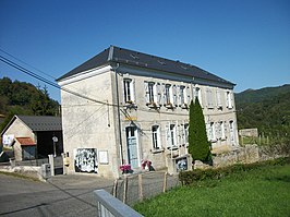 | |||
| Gemeentehuis | |||
| |||

Nistos is een gemeente in het Franse departement Hautes-Pyrénées (regio Occitanie) en telt 228 inwoners (2005). De plaats maakt deel uit van het arrondissement Bagnères-de-Bigorre.
Geografie
De oppervlakte van Nistos bedraagt 31,0 km², de bevolkingsdichtheid is 7,4 inwoners per km².

Demografie
Onderstaande figuur toont het verloop van het inwonertal (bron: INSEE-tellingen).

Afbeeldingen
-
 Uitzicht op Bas-Nistos
 -
 Haut-Nistos - Église de l'Assomption
 -
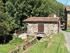
 Haut-Nistos - Watermolen van Jouannot
 -
 Haut-Nistos - Watermolen van Gerlé
 -
 Cap Nestès - Col de Sonères
 -
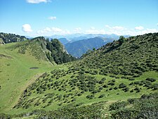
 Cap Nestès - Langlaufparcour in de zomer


Mediabestanden
Zie de categorie Nistos van Wikimedia Commons voor mediabestanden over dit onderwerp.
- ↑ Populations légales 2021.


