Richmondshire
Niet-metropolitaans district in Engeland  | |||
|---|---|---|---|
  | |||
| Situering | |||
| Land | Engeland | ||
| County | North Yorkshire | ||
| Regio | Yorkshire and the Humber | ||
| Coördinaten | 54°19'48"NB, 2°0'43"WL | ||
| Algemeen | |||
| Oppervlakte | 1318,7069[1] km² | ||
| Inwoners (2018[2]) | 53.244 (40 inw./km²) | ||
| Hoofdplaats ONS-code | Richmond E07000166 | ||
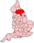
| Detailkaart | |||
 | |||
| |||

Richmondshire is een Engels district in het shire-graafschap (non-metropolitan county OF county) North Yorkshire en telt 47.010 inwoners. De oppervlakte bedraagt 1319 km².
Van de bevolking is 15,2% ouder dan 65 jaar. De werkloosheid bedraagt 2,4% van de beroepsbevolking (cijfers volkstelling 2001).
Plaatsen in district Richmondshire
- Catterick Garrison
- Keld
- Reeth
Civil parishes in district Richmondshire
Akebar, Aldbrough, Appleton East and West, Arkengarthdale, Arrathorne, Aske, Askrigg, Aysgarth, Bainbridge, Barden, Barton, Bellerby, Bishopdale, Bolton-on-Swale, Brompton-on-Swale, Brough with St. Giles, Burton-cum-Walden, Caldbergh with East Scrafton, Caldwell, Carlton Highdale, Carlton Town, Carperby-cum-Thoresby, Castle Bolton with East and West Bolton, Catterick, Cleasby, Cliffe, Colburn, Constable Burton, Coverham with Agglethorpe, Croft-on-Tees, Dalton, Dalton-on-Tees, Downholme, Easby, East Hauxwell, East Layton, East Witton, Ellerton Abbey, Ellerton-on-Swale, Eppleby, Eryholme, Finghall, Forcett and Carkin, Garriston, Gayles, Gilling with Hartforth and Sedbury, Grinton, Harmby, Hauxwell, Hawes, High Abbotside, Hipswell, Hornby, Hudswell, Hunton, Hutton Hang, Kirby Hill, Leyburn, Low Abbotside, Manfield, Marrick, Marske, Melbecks, Melmerby, Melsonby, Middleham, Middleton Tyas, Moulton, Muker, New Forest, Newbiggin, Newsham, Newton Morrell, Newton-le-Willows, North Cowton, Patrick Brompton, Preston-under-Scar, Ravensworth, Redmire, Reeth, Fremington and Healaugh, Richmond, Scorton, Scotton, Skeeby, Spennithorne, St. Martin's, Stainton, Stanwick St. John, Stapleton, Thoralby, Thornton Rust, Thornton Steward, Tunstall, Uckerby, Walburn, Wensley, West Hauxwell, West Layton, West Scrafton, West Witton, Whashton.
Bronnen, noten en/of referenties
|
Geplaatst op: 18-02-2006 | Dit artikel is een beginnetje over landen & volken. U wordt uitgenodigd om op bewerken te klikken om uw kennis aan dit artikel toe te voegen. |  |


