Hrabstwo Shasta
| hrabstwo | |||
 | |||
| Państwo |
| ||
|---|---|---|---|
| Stan |
| ||
| Siedziba | Redding | ||
| Kod statystyczny | FIPS 6-4: 06089 | ||
| Powierzchnia | 9964,82 km²[1] | ||
| Populacja (2009) • liczba ludności |
| ||
Położenie na mapie Kalifornia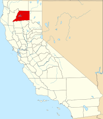 | |||
| 40°45′36″N 122°02′24″W/40,760000 -122,040000 | |||
| |||
| Strona internetowa | |||


Hrabstwo Shasta (ang. Shasta County) – hrabstwo w stanie Kalifornia w Stanach Zjednoczonych. Obszar całkowity hrabstwa obejmuje powierzchnię 3847,44 mil² (9964,82 km²). Według szacunków United States Census Bureau w roku 2009 miało 181 099 mieszkańców[2].
Hrabstwo powstało w 1850 roku[3]. Na jego terenie znajdują się[4]:
- miejscowości – Anderson, Redding, Shasta Lake,
- CDP – Bella Vista, Big Bend, Burney, Cassel, Cottonwood, Fall River Mills, French Gulch, Hat Creek, Keswick, Lakehead, McArthur, Millville, Montgomery Creek, Mountain Gate, Old Station, Palo Cedro, Round Mountain, Shasta, Shingletown.
Przypisy
- ↑ US Census Bureau: Population, Housing Units, Area, and Density: 2000. [dostęp 2012-11-13]. [zarchiwizowane z tego adresu (2015-07-08)]. (ang.).
- ↑ a b US Census Bureau: Shasta County. Quickfacts. [dostęp 2011-01-31]. (ang.).
- ↑ National Association of Counties: Shasta County, CA. [dostęp 2011-01-31]. (ang.).
- ↑ National Association of Counties: Places in Shasta County, CA. [dostęp 2011-01-31]. (ang.).
- p
- d
- e
|

- Wikiprojekt:Kalifornia
Kontrola autorytatywna (hrabstwo w stanie Kalifornia):


